Whitman, Nebraska

Last updated

Whitman, Nebraska
Whitman, NE.jpg
USA Nebraska location map.svg
Red pog.svg
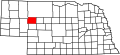
Whitman
Location within the state of Nebraska
Coordinates: 42°2′31″N101°31′24″W / 42.04194°N 101.52333°W / 42.04194; -101.52333
Country United States
State Nebraska
County Grant
Elevation
3,602 ft (1,098 m)
Time zone UTC-7 (Mountain (MST))
  Summer (DST) UTC-6 (MDT)
ZIP code
69366
FIPS code 31-52890
GNIS feature ID834693

Whitman is an unincorporated community in northeastern Grant County, Nebraska, United States. It lies along Nebraska Highway 2, east of the village of Hyannis, the county seat of Grant County. [1] The University of Nebraska-Lincoln Gudmundsen Sandhills Laboratory lies just north of the community. [2] Although Whitman is unincorporated, it has a post office, with the ZIP code of 69366. [3]

History

Whitman was established in the 1860s when the railroad was extended to that point. [4] It was named after the town of Whitman, Massachusetts by a railroad official. [5] [6]

The community was struck by an unwarned tornado on June 25, 2024, which caused damages to houses, trees, and two of the city's three communication towers. One person was injured south of the community. [7]

The town is the setting for the opening pages of Anton Myers' "Once an Eagle" as the hometown of protagonist Sam Damon.

Related Research Articles

<span class="mw-page-title-main">Ashby, Nebraska</span> Unincorporated community in Grant County, Nebraska, United States

Ashby is an unincorporated community in Grant County, Nebraska, United States. Its elevation is 3,843 feet, and it is located at 42°1′19″N101°55′40″W. It lies along Nebraska Highway 2, 9 miles west-northwest of Hyannis, the county seat of Grant County. It has a post office with the ZIP code 69333.

Big Bend is an unincorporated community in Calhoun County, West Virginia, United States. It lies along West Virginia Route 5 northwest of the town of Grantsville, the county seat of Calhoun County, along the Little Kanawha River. Its elevation is 682 feet. It has a post office with the ZIP code 26136.

<span class="mw-page-title-main">Alkol, West Virginia</span> Unincorporated community in West Virginia, United States

Alkol is an unincorporated community in eastern Lincoln County, West Virginia, United States. It lies along West Virginia Route 3, southeast of the town of Hamlin, the county seat of Lincoln County. Its elevation is 748 feet (228 m). Although it is unincorporated, it has a post office with the ZIP code 25501.

<span class="mw-page-title-main">Griffithsville, West Virginia</span> Unincorporated community in West Virginia, United States

Griffithsville is an unincorporated community in eastern Lincoln County, West Virginia, United States. It has a population of 1,101. It lies along West Virginia Route 3 southeast of the town of Hamlin, the county seat of Lincoln County. Its elevation is 659 feet (201 m). It has a post office with the ZIP code 25521.

Ranger is an unincorporated community in western Lincoln County, West Virginia, United States. It lies along West Virginia Route 10 southwest of the town of Hamlin, the county seat of Lincoln County. Its elevation is 614 feet (187 m). It has a post office with the ZIP code 25557. Ranger is served by the Guyan River VFD.

<span class="mw-page-title-main">Champion, Nebraska</span> Census-designated place in Nebraska, United States

Champion is an unincorporated community and census-designated place in central Chase County, Nebraska, United States. As of the 2010 census, it had a population of 103. It has a post office with the ZIP code 69023.

<span class="mw-page-title-main">Dickens, Nebraska</span> Unincorporated community in Nebraska, United States

Dickens is an unincorporated community in southwestern Lincoln County, Nebraska, United States. It lies along Nebraska Highway 23 southwest of the city of North Platte, the county seat of Lincoln County. Its elevation is 3,136 feet (956 m). The community is named for Charles Dickens. Although Dickens is unincorporated, it has a post office, with the ZIP code of 69132.

<span class="mw-page-title-main">Amelia, Nebraska</span> Unincorporated community in Nebraska, United States

Amelia is an unincorporated community in southwestern Holt County, Nebraska, United States. It lies along local roads near Nebraska Highways 11 and 95, southwest of the city of O'Neill, the county seat of Holt County. The community is named for Amelia A. Bliss. Although Amelia is unincorporated, it has a post office, with the ZIP code of 68711.

<span class="mw-page-title-main">Ames, Nebraska</span> CDP in Nebraska, United States

Ames is an unincorporated hamlet in southern Dodge County, Nebraska, United States. As of the 2010 census it had a population of 24.

<span class="mw-page-title-main">Angora, Nebraska</span> Unincorporated community in Nebraska, United States

Angora is an unincorporated community in northern Morrill County, Nebraska, United States. It lies along U.S. Route 385, north of the city of Bridgeport, the county seat of Morrill County. The community was established in 1900 by the Chicago, Burlington, and Quincy Railroad; it was named for the Turkish city of Ankara, which was then known as Angora. The Angora post office was established in 1901, and it remains open with the assigned ZIP code of 69331.

<span class="mw-page-title-main">Bingham, Nebraska</span> Unincorporated community in Sheridan County, Nebraska, United States

Bingham is an unincorporated community in southeastern Sheridan County, Nebraska, United States. It lies along Nebraska Highway 2, south-southeast of the city of Rushville, the county seat of Sheridan County. Its elevation is 3,894 feet (1,187 m).

<span class="mw-page-title-main">Inavale, Nebraska</span> Census-designated place in Webster County, Nebraska, United States

Inavale is a census-designated place in western Webster County, Nebraska, United States.

<span class="mw-page-title-main">Keystone, Nebraska</span> Census-designated place in Nebraska, United States

Keystone is an unincorporated community and census-designated place in central Keith County, Nebraska, United States. As of the 2010 census its population was 59.

<span class="mw-page-title-main">Lakeside, Nebraska</span> Unincorporated community in Sheridan County, Nebraska, United States

Lakeside is an unincorporated community in southern Sheridan County, Nebraska, United States. It lies along Nebraska Highway 2 and Nebraska Highway 250, south of the city of Rushville, the county seat of Sheridan County, at an elevation of 3,881 feet (1,183 m). Lakeside has a post office, with ZIP code 69351.

<span class="mw-page-title-main">Lemoyne, Nebraska</span> Census-designated place in Nebraska, United States

Lemoyne is an unincorporated community and census-designated place in northwestern Keith County, Nebraska, United States. As of the 2010 census it had a population of 82.

<span class="mw-page-title-main">Martell, Nebraska</span> Unincorporated community and Census designated place in Nebraska, United States

Martell is an unincorporated community in southwestern Lancaster County, Nebraska, United States. It lies along local roads southwest of the city of Lincoln, the county seat of Lancaster County and Nebraska's state capital. Although Martell is unincorporated, it has a post office, with the ZIP code of 68404.

<span class="mw-page-title-main">Purdum, Nebraska</span> Unincorporated community in Blaine County, Nebraska, United States

Purdum is an unincorporated community in northwestern Blaine County, Nebraska, United States. It lies along local roads northwest of the village of Brewster, the county seat of Blaine County. Its elevation is 2,700 feet (823 m). Although Purdum is unincorporated, it has a post office, with the ZIP code of 69157. The town is also home to the Purdum State Bank, and a half-dozen small businesses, a church, and a fire station. In the immediate environs are several livestock ranches.

<span class="mw-page-title-main">Marsland, Nebraska</span> Unincorporated community in Nebraska, United States

Marsland is an unincorporated community in southwestern Dawes County, Nebraska, United States. It lies on the Niobrara River along Nebraska Highways 2 and 71, 18 miles south of Crawford, and southwest of the city of Chadron, the county seat of Dawes County. Its elevation is 4,160 feet (1,298 m), and its ZIP code is 69354.

<span class="mw-page-title-main">Mills, Nebraska</span> Unincorporated community in Nebraska, United States

Mills is an unincorporated rural hamlet in northeastern Keya Paha County, Nebraska, United States. It lies along local roads northeast of the village of Springview, the county seat of Keya Paha County. Its elevation is 1,919 feet (585 m). Although Mills has a post office, covering the ZIP code of 68753, Google Maps cartographers didn't bother mapping the hamlet or its vicinity. The ZCTA for the entire ZIP code 68753 had a population of 106 at the 2000 census, some of whom live outside the hamlet itself.

<span class="mw-page-title-main">St. Libory, Nebraska</span> Census-designated place in Nebraska, United States

St. Libory or Saint Libory is an unincorporated community and census-designated place (CDP) in southeastern Howard County, Nebraska, United States. As of the 2010 census it had a population of 264.

References

  1. Rand McNally. The Road Atlas '08. Chicago: Rand McNally, 2008, p. 62.
  2. Gudmundsen Sandhills Laboratory
  3. Zip Code Lookup
  4. "Hyannis, Grant County". Center for Advanced Land Management Information Technologies. University of Nebraska. Retrieved August 9, 2014.
  5. Alan Boye (April 1, 2007). The Complete Roadside Guide to Nebraska. U of Nebraska Press. p. 386. ISBN   978-0-8032-3378-2.
  6. Fitzpatrick, Lillian L. (1960). Nebraska Place-Names. University of Nebraska Press. p. 69. ISBN   0-8032-5060-6. A 1925 edition is available for download at University of Nebraska—Lincoln Digital Commons.
  7. "Tornado in Whitman injures one, destroys homes". News Channel Nebraska. June 26, 2024. Retrieved June 26, 2024.