Jhapa District is a district of Koshi Province in eastern Nepal named after a Rajbanshi Surjapuri language word "Jhapa", meaning "to cover" (verb). The 2021 Nepal Census, puts the total population of the district at 994,090. The total area of the district is 1,606 square kilometres.
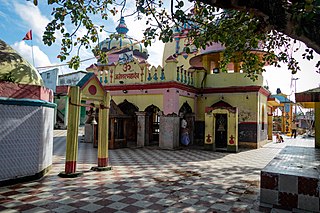
Mahottari District, a part of Madhesh Province, is one of the seventy-seven districts of Nepal. The district, with Jaleshwar as its district headquarter, covers an area of 1,002 km2 (387 sq mi) and had a population of 553,481 in 2001, 627,580 in 2011 and 705,838 in 2021 census. Its headquarters is located in Jaleshwar, a neighbouring town of the historical city of Janakpur. The name Jaleshwar means the 'God in Water'. One can find a famous temple of Lord Shiva in Water there. Jaleshwar lies at a few kilometres distance from the Nepal-India border and has a majority Maithili population.

Parsa District, a part of Madhesh Province in Terai plain, is one of the seventy-seven districts of Nepal. The district, with Birgunj as its district headquarters, covers an area of 1,353 km2 (522 sq mi) and has a population (2001) of 497,219. According to the locals, Parsa is named after the Parashnath temple situated in Mahuwan.

Rautahat District, a part of Madhesh Province, is one of the seventy-seven districts of Nepal. The district headquarter is Gaur, including municipalities like Garuda, Chandrapur, Paroha, covers an area of 1,126 km2 and had a population of 545,132 in 2001 and 686,722 in 2011. This district has a total of 2 VDCs and 16 municipalities. Among other districts, Rautahat has the largest percent of Muslims in Nepal, about 19.7%. The most Muslim densely village Bairiya बैरिया but Majority of people in the District follow Hinduism. Sri Ram Sugar Mill is the only sugar mill located in Garuda municipality. The well known shiva temple located in Shivnagar, which is looked after by Sah and Jha family. The historical temple of Goddess Durga is in Matsari.Every year, the temple welcomes millions of devotees from different parts of Nepal and India as well on the occasion of Navaratri. Late Shri Gulab Narayan Jha, the first person to represent Madhesis in politics, was permanent resident of this village. There is a place called Najarpur in Chandrapur where whole village is vegetarian. They are not even allowed to buy or sell any alcoholic beverages and buying and selling of tobacco products is also prohibited.
Sarlahi, a part of Madhesh Province, is one of the seventy-seven districts of Nepal. According to new laws, a combination of more than two or four villages makes a municipality, which covers an area of 1,259 km2 (486 sq mi) and had a population of 635,701 in 2001,769,729 in 2011 and 862,470 in 2021.

Sunsari District is one of 14 districts in Koshi province of eastern Nepal. The district is located in the eastern part of the Outer Terai and covers an area of 1,257 km2 (485 sq mi). According to the 2011 Nepal census, the population was 753,328. The district headquarters is located in Inaruwa.
Kohalpur is a municipality in Banke District of Lumbini province of Nepal. The municipality was established on 18 May 2014 merging the existing two Village Development Committees i.e. Rajhena and Kohalpur. The town is in East-West highway and one of the fastest developing places in Nepal. A neighboring city Nepalgunj is on South (16 km [9.9 mi]), with Ghorahi city (135 km [84 mi]) to west in Dang District and towards south further 6 km (3.7 mi) is the Indian border. In fact it is a growing city in the western region of Nepal. It has a junction to diverse the roadway transport to east, west, north and south from the city.

Inaruwa is the headquarter of Sunsari district that lies in the Koshi province of Eastern Nepal. Inaruwa is a municipality since the time of Panchayat in the year 2047 BS. After 2015, it has been operating under a mayor-council form of government and is currently led by Mayor Kedar Bhandari. Spanning 77.92 square kilometers, the municipality is home to a population of nearly 75 thousand residents.
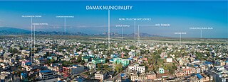
Damak, a city in eastern Nepal, is one of the oldest municipalities in Jhapa District in Koshi Province in eastern Nepal. It is situated between the Ratuwa River in the east and the Maawa River in the west. It has Sivalik Hills in its north and ends with the intersection of Ratuwa River and Maawa River in the south. Mahendra Highway, the longest highway of Nepal, bisects the municipality. It is the largest city in Jhapa District with a population of 107,410 in 2021.
Tandi is a city in the Ratnanagar Municipality of the Chitwan District in Nepal. It lies on the eastern side of Chitwan district, and is at the entrance point of Sauraha Chitwan National Park, a Major Tourist destination in Nepal.It is the second largest and oldest Urban Area of the district..This Beautiful Town has got the Space for All Major Banks and isurance Co.Of Nepal.This is the fastes Growing Town in Chitwan.It has got a very well Equipped National level Hospital which serves the people around Eastern part of Chitwan and makwanpur District.Almost 95% of the municipal area has got well managed paved roads.Tandi being the heart of the Ratnanagar,it is famous for Entry point to Sauraha and also renowned for Especial Tharu cuisine like ghunghi,Haas ko chhoila etc.this town has got all the basic to advanced facility of a (A-) class Town.
Mechinagar is a municipality in Jhapa District, Koshi Province, Nepal and is the main entry point from India on Nepal's eastern border. Nepal's customs office is in Kakarvitta, a section of the municipality. The city lies 475 km southeast of the capital Kathmandu and 115 km east of Biratnagar, the capital of Province No. 1.
Kolhabi is a municipality in Bara District in the Madhesh Province of Nepal. It was formed in 2016 occupying current 11 sections (wards) from previous 11 former VDCs. It occupies an area of 157.4 km2 with a total population of 43,036.

Bardibas is a municipal area (municipality) and a town located in Mahottari District of Madhesh Province of Nepal. It is located at latitude: 26°54'6.84" to 27°08'46.90" and longitude: 85°47'42.67" to 85°56'42.97". The municipality is surrounded by Dhalkebar of Mithila municipality, Dhanusha District in the East and Ishworpur municipality of Sarlahi District in the West, Kamalamai municipality of Sindhuli District, Bagmati Province falls in the North and Bhangaha, Aurahi and Gaushala municipalities are located in the South.

Dudhauli is a municipality of the Sindhuli District in the Janakpur Zone of south-eastern Nepal.
Meghauli is a small city and former Village Development Committee that is now part of Bharatpur Metropolitan City in Bagmati Province of central Nepal.
Jhorahat is a village development committee in Morang District in the Koshi Zone of south-eastern Nepal. According to the most recent administrative division, Jhorahat is in Gramthan Gaunpalika Ward Number-2 of Province Number 1 of Nepal. In the south, it is bordered to Biratnagar metropolitan city, the second largest city of Nepal. At the time of the 2001 Nepal census it had a population of 4844 people with 2457 male population and 2387 female population.
Godawari is a municipality in Lalitpur District in Bagmati Province of Nepal. It was established on 2 December 2014 by merging the former Village development committees Godawari, Badikhel, Bisankhunarayan, Godamchaur and Thaiba of Lalitpur District of Bagmati Zone. The municipality area was again expanded in March 2017 to include in total 12 previous VDCs. The six VDCs added were Devichaur, Dukuchhap, Chhampi, Thecho, Chapagaun, Jharuwarasi and Lele. The centre of this municipality is located at Bajrabarahi.
Satterjhora, a village development committee in Sunsari District in Province No. 1 of south-east Nepal. Its population (2011) was 9,507 in 1,889 households. Among them the male and female population was about 4,539 and 4,968 respectively.
Krishnapur is a municipality in Kanchanpur District in Sudurpashchim Province of the far-western development region of Nepal. In the 2011 national census, there were 36,706 people living in 6,723 individual households. It was formed as municipality in 2015 by merger of Krishnapur VDC, Raikwar Bichwa VDC and part of Dekathbhuli VDC.
Bhagwanpur is a rural municipality in Siraha District in Province No. 2 of south-eastern Nepal. At the time of the 2011 Nepal census it had a population of 20957 people living. It is located nearly 370 kilometers or 107 miles east of the capital, Kathmandu.