
Man Mohan Adhikari (Magi) (Nepali: मन मोहन अधिकारी; 9 June 1920 – 26 April 1999) was the 31st Prime Minister of Nepal from 1994 to 1995, representing the Communist Party of Nepal (Unified Marxist-Leninist). He is the first communist Prime Minister in Nepal and one of the first communist politician in the world to be democratically elected as a head of government.

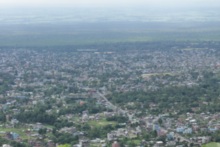
Biratnagar is a metropolitan city in Nepal, which serves as the capital of Koshi Province. With a Metropolitan Urban Agglomeration population of 756,000 as per the 2022 census, it is the largest city in the province and also the headquarters of Morang district. As per the preliminary report of 2022 Nepal census, Biratnagar Metropolitan has an estimated city population of 756,000, including the population of connected towns like Katahari, Tankisinuari, etc. It is the administrative center of the Greater Birat Development Area which incorporates the cities of Biratnagar-Itahari-Gothgau-Biratchowk-Dharan primarily located on the Koshi Highway in Eastern Nepal, with an estimated total urban agglomerated population of 804,300 people living in 159,332 households including town of Ithari. Biratnagar is located 399 km (248 mi) east of the capital, Kathmandu, and 6 km (3.7 mi) north of the bordering town of Jogbani in the Indian state of Bihar.
Dharan is a sub-metropolitan city in Sunsari District of Koshi Province, Nepal, which was established as a fourth municipality in the Kingdom in 1958. It is the third most populous city in Eastern Nepal after Biratnagar and Itahari. The Nepali word "dharan" means a saw pit. The rainforest from which the tree trunks came is still just on the edge of the city. Much later the British Gurkha camp opened in October 1960. The use of the camp by British Gurkhas finished in the mid 1990s. Dharan has an estimated city population of 173,096 living in 34,834 households as per the 2021 Nepal census. It is one of the cities of the Greater Birat Development Area which incorporates the cities of Biratnagar-Itahari-Gothgau-Biratchowk-Dharan primarily located on the Koshi Highway in Eastern Nepal, with an estimated total urban agglomerated population of 804,300 people living in 159,332 households. It is the largest city in the province number one by Area. It covers 192.32 square kilometers while Biratnagar and Itahari is 2nd and 3rd biggest cities by Area

Morang District is located in Koshi Province in eastern Nepal. It is an Outer Terai district. It borders Jhapa to the east, Dhankuta and Panchthar to the north, Sunsari to the west, and Bihar, India, to the south. Morang has one metropolitan city (Biratnagar), eight municipalities and eight rural municipalities. The total area of Morang is 1,855 km2 (716 sq mi). The lowest elevation point is 60 meters and the highest is 2,410 meters above sea level. The headquarters of Morang is connected by the Koshi National Highway to the east–west Mahendra National Highway at Itahari, Sunsari. Morang is also connected to the Hill parts of the eastern region of Nepal. Morang is the core industrial sector for the eastern region of Nepal.

Sunsari District is one of 14 districts in Koshi province of Nepal. The district is located in the eastern part of the Outer Terai and covers an area of 1,257 km2 (485 sq mi). According to the 2011 Nepal census, the population was 753,328. The district headquarters is located in Inaruwa.

Kosi or Koshi was one of the fourteen zones of Nepal until the restructure of zones to provinces. The headquarters of Kosi Zone was Biratnagar which was also its largest city. Other cities of Kosi Zone were Inaruwa, Dharan, Dhankuta, Jhumka, Duhabi, Tarahara and Itahari. Its main rivers were Arun, Tamor and Sapta Koshi.

Inaruwa is the headquarter of Sunsari district that lies in the Koshi province of Eastern Nepal. Inaruwa is a municipality since the time of Panchayat in the year 2047 BS. After 2015, it has been operating under a mayor-council form of government and is currently led by Mayor Kedar Bhandari. Spanning 77.92 square kilometers, the municipality is home to a population of nearly 75 thousand residents.

Ilam is one of four urban municipalities of Ilam District, which lies in the Mahabharata hilly range of Koshi Province, eastern Nepal. Ilam also acts as the headquarters of Ilam District. Being the largest producer region for Nepali tea, its tea farms are a major tourist attraction in Koshi Province. Ilam is also famous for its natural scenery and landscapes as well as its diverse agricultural economy which specializes in horticultural crop production.
Rangeli is a Municipality and rural market town in Morang District in the Koshi Zone of south-eastern Nepal. This municipality was formed merging existing four villages i.e.Amgachhi, Babiabirta, Darbesa and Rangeli itself since May 2014.
Triyuga is one of eight municipalities of Udayapur district of the Koshi Pradesh of Nepal. Gaighat is the headquarter of the municipality. According to the 1991 Nepal census, it had a population of 55,291. According to the 2011 Nepal census, Triyuga had 87,557 inhabitants. According to the 2021 Nepal census the initial population of the municipality is 104,375. It is divided into 16 wards. Triyuga Municipality was established on B.S. Chaitra 13, 2053. It was named after Triyuga River. A river which flows through the town. Triyuga is the 3rd largest municipality in Nepal and 1st largest in Koshi Pradesh in term of size (area). The total area of the municipality is 547.43 square kilometres (211.36 sq mi)
Tumlingtar is a region and a town, in Sankhuwasabha district of Province No. 1 of Eastern Nepal, between the Arun and Sabha rivers. It is located in Sankhuwasabha District. It is also the deepest valley of the world and largest ṭār of Nepal. The total area of Tumlingtar is 8.5 sq.km. It is ethinically diverse place.

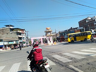
Itahari is a sub-metropolitan city in the Sunsari District of Koshi Province of Nepal. Itahari City has grown as an important business hub of eastern Nepal. It is the second most populous city in Eastern Nepal after Biratnagar. Situated at a distance of 25 kilometres north of the provincial capital of Biratnagar, 16 kilometres south of Dharan and 92 kilometres west of Kakarbhitta, Itahari serves as a junction point of the east-west Mahendra Highway and the north–south Koshi Highway. Itahari has an estimated city population of 1,98,098 living in 40,207 households as per 2021 Nepal census. It is one of the fastest-growing cities in Eastern Nepal. It is one of the cities of the Greater Birat Development Area which incorporates the cities of Biratnagar-Itahari-Gothgau-Biratchowk-Dharan primarily located on the Koshi Highway in Eastern Nepal, with an estimated total urban agglomerated population of 804,300 people living in 159,332 households.

Mahendra Highway, also called East-West Highway, runs across the Terai geographical region of Nepal, from Mechinagar in the east to Bhim Datta in the west, cutting across the entire width of the country. It is the longest highway in Nepal and was constructed by cooperation of various countries. The highway is named after King Mahendra Shah.

Duhabi is a municipality in Sunsari District in the Koshi Zone of south-eastern Nepal. At the time of the 2001 Nepal census it had a population of 17,574. Duhabi is situated in between Itahari and Biratnagar, on the bank of Budi River. It is the center of Sunsari–Morang industrial corridor.

Prakashpur is a small town in Sunsari District in the Koshi Zone in southeastern Nepal.It lies in ward no.10 of Barahakshetra municipality.It is near the Indo-Nepal border.It is famous for its beautiful and peaceful environment. Most of the people come here to visit Koshi river which is one of the longest river in Nepal. It is also famous for its diversity in culture.
Rajghat is a small village in the Urlabari Municipality, comprising two wards; 8 and 9 in the Morang District in the Koshi Zone of south-eastern Nepal. It is located in North-East part of Morang and 1.5 kilometers south of the East West national highway of Nepal. Durgapuri Bazar is the local town of Rajghat. This place is one of the major habitat of indigenous Dhimal, Santhal,and Mushahar communities.

Aitabare or Aaitabare is a market village that is the center of Ward 7 of the Kanepokhari Rural Municipality of the Morang District in Province No. 1 of south-eastern Nepal. The population of Kanepokhari Ward 7 in 2011 was 4,241.

Koshi Province is the autonomous easternmost province adopted on 20 September 2015 by Constitution of Nepal. The province is rich in natural resources, tourist attractions, recreational activities, and natural beauty. The province covers an area of 25,905 km2 (10,002 sq mi), about 17.5% of the country's total area. With the industrial city of Biratnagar as its capital, the province includes major eastern towns of Birtamod, Sundar Haraincha, Damak, Dharan, Itahari, Triyuga Municipality and Mechinagar, and the Mount Everest, Kangchenjunga and Ama Dablam. Koshi River, the largest river of the nation, is the province's western boundary. Under the First-past-the-post voting system issued by the Constituency Delimitation Commission, Nepal, the province hosts 28 parliamentary seats and 56 provincial assembly seats.
Sundar Haraicha is a municipality in Morang District of Koshi Province in Nepal. It is centered around Biratchowk town which is the gateway to Biratnagar. It borders Itahari Sub- Metropolitan city to the West, Dharan Sub- Metropolitan city to the Northwest and Belbari municipality to the East and is connected by the Mahendra Highway. It is one of the fastest growing cities in the Eastern Nepal and the second largest city of Morang district after Biratnagar with 121,305 inhabitants living in 26,677 households. It consists the town centres of Biratchowk and Gothgaun which are parts of the Greater Birat Development Area which incorporates the cities of Biratnagar-Itahari-Gothgau-Biratchowk-Dharan primarily located on the Koshi Highway in Eastern Nepal, with an estimated total urban agglomerated population of 804,300 people living in 159,332 households.
Budhi Khola is a river passing though Itahari in Nepal. The river acts as a border between Sunsari and Morang districts. The main catchment of the river lies between Dharan and Tarahara and flows from northern mid hills near Dharan, passes Itahari, Dhuhabi and finally towards India. In India and southern Nepal, the river is called Keshaliya Khola. In 2017, the flood in the river killed six peoples.

