
Biratnagar is a metropolitan city in Nepal, which serves as the capital of Koshi Province. With a Metropolitan Urban Agglomeration population of 244,750 as per the 2021 census, it is the largest city and fastest growing city in the province and also the headquarters of Morang district. As per the preliminary report of 2022 Nepal census, Biratnagar Metropolitan has an estimated city population of 243,927 excluding the suburban areas which are now very well connected to the old town. It is the administrative center of the Greater Birat Development Area which incorporates the cities of Biratnagar and its suburbs and towns of-Itahari-Gothgau-Biratchowk-Dharan primarily located on the Koshi Highway in Eastern Nepal, with an estimated total urban agglomerated population of 804,300 people in 159,332 households including the town of Ithari. Biratnagar is located 399 km (248 mi) east of the capital, Kathmandu, and 6 km (3.7 mi) north of the bordering town of Jogbani in the Indian state of Bihar which is very well connected through Rani Path and Koshi Path. It is one of the major entry point in Nepal for Businessmen as well as Tourists who come to visit Nepal for various purposes. A customs duty is required to be paid for Indian vehicles in Nepal and Vice-versa.
Dharan is a sub-metropolitan city in Sunsari District of Koshi Province, in eastern Nepal, which was established as a fourth municipality in the Kingdom in 1958. It is the third most populous city in eastern Nepal after Biratnagar and Itahari. The Nepali word "dharan" means a saw pit. The rainforest from which the tree trunks came is still just on the edge of the city. Much later the British Gurkha camp opened in October 1960. The use of the camp by British Gurkhas finished in the mid-1990s. Dharan has an estimated city population of 173,096 living in 34,834 households as per the 2021 Nepal census. It is one of the cities of the Greater Birat Development Area which incorporates the cities of Biratnagar-Itahari-Gothgau-Biratchowk-Dharan primarily located on the Koshi Highway in Eastern Nepal, with an estimated total urban agglomerated population of 804,300 people living in 159,332 households. It is the largest city in the Koshi Province by Area. It covers 192.32 square kilometers while Biratnagar and Itahari is 2nd and 3rd biggest cities by Area

Sunsari District is one of 14 districts in Koshi province of eastern Nepal. The district is located in the eastern part of the Outer Terai and covers an area of 1,257 km2 (485 sq mi). According to the 2011 Nepal census, the population was 753,328. The district headquarters is located in Inaruwa.

Kosi or Koshi was one of the fourteen zones of Nepal until the restructure of zones to provinces. The headquarters of Kosi Zone was Biratnagar which was also its largest city. Other cities of Kosi Zone were Inaruwa, Dharan, Dhankuta, Jhumka, Duhabi, Tarahara and Itahari. Its main rivers were Arun, Tamor and Sapta Koshi.

Budhlada is a municipal council located in the Mansa district of the state of Punjab, India. The area's main industry is agriculture, which provides the majority of employment opportunities in the region. The municipal council of Budhlada is divided into 19 wards, and regular elections are held every five years. It has held the status of a Class II Municipal Council since the 1950s.
Jaspur is a developing town and a municipal board in Udham Singh Nagar district in the Indian state of Uttarakhand.
Kukshi is a town in Dhar district of Madhya Pradesh state, India. Kukshi has population of around 37,482 making it a Tier-3 city and a Semi-Urban centre. It is a Nagar Parishad. Kukshi is famous for the business of cotton, chilli, gold and silver, and ready made garments.

Inaruwa is the headquarter of Sunsari district that lies in the Koshi province of Eastern Nepal. Inaruwa is a municipality since the time of Panchayat in the year 2047 BS. After 2015, it has been operating under a mayor-council form of government and is currently led by Mayor Kedar Bhandari. Spanning 77.92 square kilometers, the municipality is home to a population of nearly 75 thousand residents.

Bhadravati is a city and a municipal council in Chandrapur district in the state of Maharashtra, India. It lies 26 km from Chandrapur city. Bhadravati city has recently bagged the Best City in 'Innovation & Best Practices' award under the population Category - 50K to 1 Lakh from the Government of India under Swach Surverkshan Awards-2021. It has also bagged 8th Rank in being the cleanest city under category population Category - 50K to 1 Lakh under Swach Surverkshan Awards-2021 amongst 132 cities nominated.
Narsinghgarh is a town and a municipality, near Rajgarh city in Rajgarh district in the Indian state of Madhya Pradesh.
Tumlingtar is a region and a town, in Sankhuwasabha district of Province No. 1 of Eastern Nepal, between the Arun and Sabha rivers. It is located in Sankhuwasabha District. It is also the deepest valley of the world and largest ṭār of Nepal. The total area of Tumlingtar is 8.5 sq.km. It is ethinically diverse place.

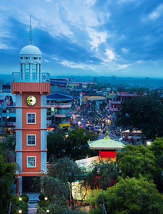
Itahari is a sub-metropolitan city in the Sunsari District of Koshi Province in Nepal. Itahari city has grown as an important business hub of eastern Nepal. It is the second most populous city in eastern Nepal after Biratnagar. Situated 25 kilometres north of the provincial capital of Biratnagar, 16 kilometres south of Dharan and 92 kilometres west of Kakarbhitta, Itahari serves as a junction point of the east-west Mahendra Highway and the north–south Koshi Highway. Itahari has an estimated city population of 198,098 living in 40,207 households as per 2021 Nepal census. It is one of the fastest-growing cities in Eastern Nepal. It is one of the cities of the Greater Birat Development Area which incorporates the cities of Biratnagar-Itahari-Gothgau-Biratchowk-Dharan primarily located on the Koshi Highway in Eastern Nepal, with an estimated total urban agglomerated population of 804,300 people living in 159,332 households.

Prakashpur is a small town in Sunsari District in the Koshi Zone in southeastern Nepal.It lies in ward no.10 of Barahakshetra municipality.It is near the Indo-Nepal border.It is famous for its beautiful and peaceful environment. Most of the people come here to visit Koshi river which is one of the longest river in Nepal. It is also famous for its diversity in culture.
Maheshkhunt is a village in Khagaria district of Bihar state, India.
Unlike some other religions, Hindus are not required to undertake pilgrimages during their lifetime. However, most Hindus go on such journeys to numerous iconic sites including those below:

Godawari Vidhya Mandir is one of the oldest schools in Itahari, Nepal. Established in 1992 AD the HSEB-affiliated school has an enrollment of over 1200 students.

Ramdhuni is a municipality located in the Sunsari district, Koshi Province of Eastern Nepal. It was established in 2014. Ramdhuni previously known as Jhumka Bazar. It is approximately 356km far from Kathmandu. This town lies in the middle of two famous cities Itahari and Inaruwa. Mahendra highway passes right through the heart of the town. Chatara Canal originates all the way from Koshi River and flows through the town from north to south. This canal plays an important role in the agriculture of Sunsari and Morang district. Ramdhuni has a total area of 91.69 square kilometers. It has a population of 63,452 of which 29,820 are males and 29,820 are females living in 11,491 individual houses.
Sundar Haraicha is a municipality in Morang District of Koshi Province in Nepal. It is centered around Biratchowk town which is the gateway to Biratnagar. It borders Itahari Sub- Metropolitan city to the west, Dharan Sub- Metropolitan city to the Northwest and Belbari municipality to the east and is connected by Mahendra Highway. It is one of the fastest growing cities in eastern Nepal and the second largest city of Morang district after Biratnagar, with 121,305 inhabitants living in 26,677 households. It consists of the town centres of Biratchowk and Gothgaun which are parts of the Greater Birat Development Area which incorporates the cities of Biratnagar-Itahari-Gothgau-Biratchowk-Dharan primarily located on the Koshi Highway in Eastern Nepal, with an estimated total urban agglomerated population of 804,300 people living in 159,332 households.
"Jhumka Gira Re" is an Indian Hindi song from the 1966 Hindi film Mera Saaya directed by Raj Khosla. It was sung by Asha Bhosle. The song was picturized on Sadhana Shivdasani. It was written by Raja Mehdi Ali Khan and composed by Madan Mohan. It has been remixed and sampled by many other artists.
