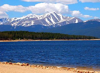
Mount Elbert is the highest summit of the Rocky Mountains of North America. With an elevation of 14,440 feet (4401.2 m), it is also the highest point in the U.S. state of Colorado and the second-highest summit in the contiguous United States after Mount Whitney, which is slightly taller. The ultra-prominent fourteener is the highest peak in the Sawatch Range, as well as the highest point in the entire Mississippi River drainage basin. Mount Elbert is located in San Isabel National Forest, 12.1 miles (19.4 km) southwest of the city of Leadville in Lake County, Colorado.

Mount Lucania in Yukon is the third-highest mountain in Canada, and the second-highest mountain located entirely within the country. A long ridge connects Mount Lucania with Mount Steele, the fifth-highest in Canada. Lucania was named by the Duke of Abruzzi, as he stood on the summit of Mount Saint Elias on July 31, 1897, having just completed the first ascent. Seeing Lucania in the far distance, beyond Mount Logan, he immediately named it "after the ship on which the expedition had sailed from Liverpool to New York," the RMS Lucania.

Hvannadalshnjúkur or HvannadalshnúkurIcelandic pronunciation:[-ˌn̥uːkʏr̥] is a pyramidal peak on the northwestern rim of the summit crater of the Öræfajökull volcano in Vatnajökull National Park, Iceland. Its summit is the highest point in the country.

The Old Man of Coniston is a fell in the Furness Fells of the Lake District in Cumbria, England, and is the highest point of the historic county of Lancashire. It is at least 2,632.62 feet (802.42 m) high, and lies to the west of the village of Coniston and the lake, Coniston Water. The fell is sometimes known by the alternative name of Coniston Old Man, or simply The Old Man. The mountain is popular with tourists and fell-walkers with a number of well-marked paths to the summit. The mountain has also seen extensive copper and slate mining activity for eight hundred years, and the remains of abandoned mines and spoil tips are a significant feature of the north-east slopes.
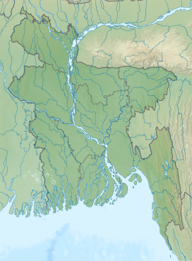
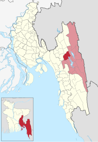
Rangamati Hill District is a district in south-eastern Bangladesh. It is a part of the Chattogram Division, and the town of Rangamati serves as the headquarters of the district. By area, Rangamati is the largest district of the country.

Rangamati is the administrative headquarter and town of Rangamati Hill District in the Chittagong Hill Tracts of Bangladesh. The town is located at 22°37'60N 92°12'0E and has an altitude of 14 metres (46 ft). It is also where Ropuiliani, a Mizo chieftess, was jailed and died, during British rule in Mizoram.

The mountains and hills of the British Isles are categorised into various lists based on different combinations of elevation, prominence, and other criteria such as isolation. These lists are used for peak bagging, whereby hillwalkers attempt to reach all the summits on a given list, the oldest being the 282 Munros in Scotland, created in 1891.
Thanchi is an upazila of Bandarban District in the Division of Chittagong, Bangladesh.

Juraichhari is an upazila of Rangamati District in the Division of Chittagong, Bangladesh.
Naniarchar is an Upazila of Rangamati District in the Division of Chittagong, Bangladesh.

Rangamati Sadar is an Upazila of Rangamati District in the Division of Chittagong, Bangladesh.

Tourism in Bangladesh includes tourism to World Heritage Sites, historical monuments, resorts, beaches, picnic spots, forests, tribal people, and wildlife of various species. Activities for tourists include angling, water skiing, river cruising, hiking, rowing, yachting, beachgoing and sea bathing.
Saka Haphong is a peak in Southeast Asia and South Asia which was discovered by A.K.M Shahidullah Kaiser Sazzad Hossain and many others. Located on the Bangladesh–Myanmar border, it is situated between Thanchi, Bandarban, Bangladesh and the Chin State of Myanmar.
Bawm or Bawm Zo, also known as Banjogi, is a Kuki-Chin language primarily spoken in Bangladesh. It is also spoken in adjacent regions of Northeast India and Myanmar. The Bawms that live on the Chittagong Hill Tracts of Bangladesh call their settlements "Bawmram", which literally means an area or location inhabited by Bawms.
Thingdawlte Tlang is a mountain in Bangladesh. It is the highest point of the Lowmbok Row range and possibly the country's 7th tallest. In December 2012 local explorer Fahim Hasan of BD Explorer summited the peak and measured its height for the first time. The name of the peak was collected by BD Explorer and confirmed by the local residents. A few days later Zaqiul Deep of Travelers of Bangladesh measured the altitude as 3,133 feet (955 m). The easiest summit route is to start from Ruma of Bandarban district. The nearest settlement is Thingdawlte (Bawm) village, for which the peak is named.

Mukhra Thuthai Haphong is a significant border peak of Bangladesh, situated in the southern part of Belaichori of Rangamati Hill District. In April 2013, Fahim Hasan of BD Explorer summitted and measured this peak for the first time. Elevation measured at 953.6 metres (3,129 ft). The name of the peak was collected by BD Explorer and confirmed by the local tribal people of Dhupanichora village. The name Mukhra Thuthai Haphong came from the Tripura language. Nearest settlement is known as Dhupanichora para. The easiest route to summit this peak is to start from Ruma of Bandarban district.

Zow Tlang or Reang Haphong is a mountain on the Bangladesh–Myanmar border. Height of the mountain is equal to 1,022 m.

Kala Pahar, also known as Debbarma Haphong in Khasi, is the highest peak of northern Bangladesh. Located near Robir bazar of Kulaura Upazila in Moulvibazar District, it is only 3–4 hours trekking distance from Azgarabad Tea Estate. This peak is also accessible from Rajki tea estate near Fultola bazar of Juri Upazila. The hill range of Kala Pahar is locally known as Longla Range. 'Kala Pahar' is the local name of the highest peak. According to Bangladesh Geographic society this hill is also known as 'Hararganj pahar'. In Bengali language 'hill' word means 'Pahar'. Situated in the north-eastern part of the country 60% of the range is in Bangladesh and the rest is in the Northern Tripura state of India. In Tripura, part of this hill is known as Raghunandan pahar. The famous ancient religious archaeological site of India ‘Unakoti’ lies at the foot of this hill. Kala Pahar is about 1,100 feet high from the sea level. In November 2015, members of a local adventure group of Bangladesh BD Explorer explored this peak and measured the highest point as 1,098 feet with a Garmin handheld GPS. During autumn, if the sky is clear, one can observe the blue water of Hakaluki haor(Largest haor of Bangladesh) from the high point of Kala Pahar. There are some Khasi establishments adjacent to this hill, such as Nunchora punji, Panaichora punji, Putichora punji and Baigonchora punji.
Binoy Kumar Dewan was a Bangladeshi politician from Rangamati belonging to Jatiya Party. He was a former member of the Jatiya Sangsad. He was a state minister of the Ministry of Local Government, Rural Development and Co-operatives too. He was also appointed an advisor of the President of Bangladesh.