Dummugudem | |
---|---|
village | |
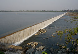
Dummugudem Barrage on Godavari | |
Coordinates: 17°51′00″N80°51′00″E / 17.8500°N 80.8500°E Coordinates: 17°51′00″N80°51′00″E / 17.8500°N 80.8500°E | |
Country | |
State | Telangana |
District | Bhadradri Kothagudem |
Area | |
• Total | 10.36 km2 (4.00 sq mi) |
Elevation | 47 m (154 ft) |
Population (2011) [1] | |
• Total | 2,589 |
• Density | 250/km2 (650/sq mi) |
Languages | |
• Official | Telugu |
Time zone | UTC+5:30 (IST) |
Vehicle registration | TS–04 |
Climate | hot (Köppen) |
Website | telangana |
Dummugudem is a village in Bhadradri Kothagudem district of the Indian state of Telangana. It is located in Dummugudem mandal of Bhadrachalam revenue division. [2]
Bhadradri Kothagudem district is a district in the eastern region of the Indian state of Telangana. The town of Kothagudem is the district headquarters. It was a part of the Khammam district prior to the re-organisation of districts in the state.
Telangana is a state in India situated on the centre-south stretch of the Indian peninsula on the high Deccan Plateau. It is the eleventh largest state and the twelfth-most populated state in India with a geographical area of 112,077 km2 (43,273 sq mi) and 35,193,978 residents as per 2011 census. On 2 June 2014, the area was separated from the northwestern part of Andhra Pradesh as the newly formed 29th state with Hyderabad as its historic permanent capital. Its other major cities include Warangal, Nizamabad and Karimnagar. Telangana is bordered by the states of Maharashtra to the north, Chhattisgarh to the east, Karnataka to the west, and Andhra Pradesh to the east and south. The terrain of Telangana region consists mostly of hills, mountain ranges, and thick dense forests covering an area of 27,292 sq. km. As of 2019, the state of Telangana is divided into 33 districts.
Bhadrachalam revenue division is an administrative division in the Bhadradri Kothagudem of the Indian state of Telangana. It is one of the 2 revenue divisions in the district which consists of 8 mandals under its administration. Bhadrachalam is the divisional headquarters of the division. The Bhadrachalam Revenue Division was originally part of East Godavari district of Andhra Pradesh up to 1959, after which it was merged through GO No. 553 on 17 Nov 1959 into Khammam district. Ashwaraopeta was also part of West Godavari district up to 1959. It was merged in Telangana region after the formation of Andhra Pradesh State with 29 states. In 2014, it was re-merged in Andhra Pradesh State with 13 districts, after the formation of Telangana state for the completion of Polavaram dam project.
On 30 November 1959, Dummagudem was carved out of East Godavari District and combined with the newly created district of Khammam. [3]
Dummagudem is located at 17°51′00″N80°51′00″E / 17.8500°N 80.8500°E . [4] It has an average elevation of 47 metres (157 ft).
Dummugudem barrage across the Godavari River was constructed nearly 150 years back by the British India engineer Sir Arthur Cotton. [5] A major lift irrigation project called Dummugudem Lift Irrigation Scheme is under development drawing water from the barrage pond. Dummugudem to Nagarjunasagar Dam tail pond lift canal is also under construction to transfer surplus Godavari river water to Krishna river.
The Godavari is India's second longest river after the Ganga. Its source is in Triambakeshwar, Maharashtra. It flows east for 1,465 kilometres (910 mi), draining the states of Maharashtra (48.6%), Telangana (18.8%), Andhra Pradesh (4.5%), Chhattisgarh (10.9%), Odisha (5.7%),ultimately emptying into the Bay of Bengal through its extensive network of tributaries. Measuring up to 312,812 km2 (120,777 sq mi), it forms one of the largest river basins in the Indian subcontinent, with only the Ganga and Indus rivers having a larger drainage basin. In terms of length, catchment area and discharge, the Godavari is the largest in peninsular India, and had been dubbed as the Vridha Ganga.
General Sir Arthur Thomas Cotton was a British general and irrigation engineer.
Dummugudem lift irrigation projects are lift irrigation schemes under execution which are located near Dummugudem, Khammam district in Telangana, India. There are three lift irrigation schemes by names Rajiv Dummugudem lift irrigation scheme, Indirasagar Rudrammakota Dummugudem lift irrigation scheme and Dummugudem to Sagar tail pond canal project. Rajiv Dummugudem lift irrigation scheme starting at 17°54′05″N80°52′45″E is planned to supply irrigation water for 200,000 acres in Khammam and Warangal districts drawing Godavari River water from the Dummugudem pond. Indira Dummugudem lift irrigation scheme starting at 17°33′49″N81°14′49″E is planned to supply irrigation water for 200,000 acres in Khammam, Krishna and West Godavari districts drawing Godavari River water from the back waters of Polavaram reservoir.
The subdivision has a population of 44,393 while Dummugudem town has a population of 3420 (2001 census). The subdivision had a literacy rate of 36% while Dummugudem town had a literacy rate of 65.8 as per the 2001 census. The literacy numbers show a contrast between rural and urban areas of the subdivision.
Literacy is traditionally defined by dictionaries as the ability to read and write. In the modern world, this is one way of interpreting literacy. One more broad interpretation sees literacy as knowledge and competence in a specific area. The concept of literacy has evolved in meaning. The modern term's meaning has been expanded to include the ability to use language, numbers, images, computers, and other basic means to understand, communicate, gain useful knowledge, solve mathematical problems and use the dominant symbol systems of a culture. The concept of literacy is expanding across OECD countries to include skills to access knowledge through technology and ability to assess complex contexts. A person who travels and resides in a foreign country but is unable to read or write in the language of the host country would be regarded by the locals as illiterate.
Yellandu is a town in Bhadradri Kothagudem district of the Indian state of Telangana. It is located in Yellandu mandal of Kothagudem revenue division.
Khammam District is a district in the eastern region of the Indian state of Telangana. The city of Khammam is the district headquarters. The district shares boundaries with Suryapet, Mahabubabad, Bhadhradhri districts and with Andhra pradesh state.
Manuguru is a census town and mandal in Bhadradri Kothagudem district in the Indian state of Telangana. It comes under Mahaboobabad parliamentary constituency and Pinapaka Assembly constituency. Manuguru is an urban area, situated on the banks of Godavari River. The town is famous for Singareni coal mines. The singareni had provided a lot of employment opportunities. Since there is a availability of coal the TS government has taken an action to construct a power plant(BTPS) in the coal city MANUGURU Pin code of Manuguru is 507117.
Chunchupalle is a census town in Bhadradri Kothagudem district of the Indian state of Telangana. It is located in Chunchupalli mandal of Kothagudem revenue division.
Palwancha is a town in Bhadradri district of the Indian state of Telangana. It is located in Palwancha mandal of Kothagudem revenue division.
Cherla is a mandal in Bhadradri Kothagudem district. It is located on the banks of River Godavari. Prior to 30 November 1959, it was a part of Bhadrachalam constancy in Khammam district.
Burgampahad is the headquarters of Burgampahad mandal in Bhadradri Kothagudem district of the Indian state of Telangana.
Gundala is a mandal of Bhadradri Kothagudem District of Telangana state in India. It is located at and is near the town of Kothagudem. The headquarters of the sub-division are in the village of Gundala. The sub-division has 17 villages under its administration. Markode, Muthapuram and Lingagudem are the other populated regions in the mandal.
Chandrugonda is a village in Chandrugonda mandal in Bhadradri Kothagudem district of Telangana, India.
Mulkalapalle, Mulakalapalli or Mulakalapally is a Mandal in Bhadradri Kothagudem district of Telangana, India.
Tekulapalle, Tekulapalli or Tekulapally is a Mandal in Bhadradri Kothagudem district of Telangana state, India.
Nagarjuna Sagar tail pond is a multipurpose reservoir located 21 km downstream from the Nagarjuna Sagar Dam across the Krishna River near Satrasala in Nalgonda district, India. Its gross water storage capacity is 6 Tmcft. The reservoir water spread area extends up to the toe of the Nagarjuna Sagar dam. The project was completed by July 2014.
Taliperu Project also known as Taliperu Reservoir is a medium irrigation project constructed across the Taliperu River, a tributary of Godavari River, located at Cherla Village and Mandal, Khammam District, Telangana. This project utilizes about 5.0 TMC of water and creates 24,500 acres (9,900 ha) of Ayacut in both Cherla and Dummugudem Mandals, Khammam District.
Taliperu is a river in the Godavari system originating in the Bijapur District of Chhattisgarh. It is a left-bank tributary of Godavari River, draining into it through a confluence located near Cherla in the Khammam District in Telangana.
Mahabubabad is a district in the Indian state of Telangana. It was a part of the Warangal district prior to the re-organisation of districts in the state in October 2016.The district shares boundaries with Suryapet, Khammam, Bhadradri Kothagudem, Warangal Rural, Jayashankar Bhupalpalle and Jangaon districts. It consists of Dornakal, Mahabubabad, Maripeda, Thorrur Municipalities.