Related Research Articles

Dorris is a city in Siskiyou County, California, United States. Its population is 860 as of the 2020 census, down from 939 from the 2010 census. The town being small, the only attractions are the flagpole and county library. The most notable people who have been residents of Dorris are two athletes who were born here.

Dangriga, formerly known as Stann Creek Town, is a town in southern Belize, located on the Caribbean coast at the mouth of the North Stann Creek River. It is the capital of Belize's Stann Creek District. Dangriga is served by the Dangriga Airport. Commonly known as the "culture capital of Belize" due to its influence on punta music and other forms of Garifuna culture, Dangriga is the largest settlement in southern Belize.

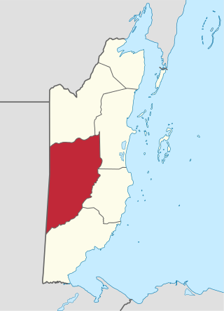
Stann Creek District is a district in the south east region of Belize. According to the 2010 census, the district had a population of 32,166 people. Its capital is the town of Dangriga, formerly known as "Stann Creek Town." Stann comes from "stanns," or safe havens used by colonialists coming from the "old world" to the "new world."

Toledo District is the southernmost and least populated district in Belize. Punta Gorda is the District capital. According to the Human Development Index (HDI), it is the second most developed region in the country. The district has a diverse topography which features rainforests, extensive cave networks, coastal lowland plains, and offshore cays. Toledo is home to a wide range of cultures such as Mopan, Kekchi Maya, Creole, Garifuna, East Indians, Mennonites, Mestizos, and descendants of US Confederate settlers.

Orange Walk District is a district in the northwest of the nation of Belize, with its district capital in Orange Walk Town.
Cayo District is a district located in the west part of Belize. It is the most extensive, second-most populous and third-most densely populated of the six districts of Belize. The district's capital is the town of San Ignacio.
Ladyville is the largest village in the country of Belize, eight miles northwest of Belize City in the Belize District. The Philip Goldson Highway connects Ladyville to Belize City.
Monkey River Town is a village in the north of the Toledo District of Belize. It is on the Caribbean Sea on the southern shore of the mouth of Belize's Monkey River. In 2011 the estimated population was 200 people.

Nim Li Punit is a Maya Classic Period site in the Toledo District of the nation of Belize, located 50 kilometres north of the town of Punta Gorda, and directly adjacent to the village of Indian Creek. Nim Li Punit is sometimes known as Big Hat or Top Hat; the name is Kekchi Maya for "Big Hat", referring to the large elaborate head-dress on a stela sculpture found on site depicting one of the site's ancient kings. It is bordered by the Maya Mountains to the west and lowland swamps and the Caribbean Sea to the east.

San Pedro Columbia is a village in Toledo District, Belize, located about two miles from the ancient Maya ruins of Lubaantun. In 2000 San Pedro Columbia had a population of about 700 people. The population is mostly Kekchi Maya with some Mopan Maya. San Pedro Columbia has Belize's largest settlement of Kekchi. Most of the population came to Belize from the Petén region of Guatemala in the late 19th century. The village is known for the hand woven embroidery produced there.

Placencia is a small village located in the Stann Creek District of Belize.

Hurricane Iris was a small, but powerful Category 4 hurricane that caused widespread destruction in Belize. Iris was the second-strongest storm of the 2001 Atlantic hurricane season, behind Hurricane Michelle. It was the ninth named storm, fifth hurricane, and third major hurricane of the year, forming from a tropical wave on October 4 just southeast of Barbados. It moved westward through the Caribbean, intensifying into a tropical storm on October 5 south of Puerto Rico, and into a hurricane on the following day. While passing south of the Dominican Republic, Iris dropped heavy rainfall that caused landslides, killing eight people. Later, the hurricane passed south of Jamaica, where it destroyed two houses. On reaching the western Caribbean Sea, Iris rapidly intensified into a Category 4 on the Saffir–Simpson scale. A small hurricane with an eye of only 7 mi (11 km) in diameter, Iris reached peak winds of 145 mph (233 km/h) before making landfall in southern Belize near Monkey River Town on October 9. The hurricane quickly dissipated over Central America, although its remnants contributed to the formation of Tropical Storm Manuel in the eastern Pacific Ocean. The hurricane caused severe damage—destroying homes, flooding streets, and leveling trees—in coastal towns south of Belize City.

Xnaheb is an archaeological site of the pre-Columbian Maya civilization, one of five primary sites identified in the southern Belize region. The center is built on a ridge of foothills that extends from the Maya Mountains, in what is now the Toledo District of Belize. Based on certain architectural similarities between the two sites, it is possible that Xnaheb was founded as an offshoot of Nim Li Punit.
Gardenia is a village in Belize District, Belize located about 20 miles (32 km) north of Belize City.
New Kendall Bridge is a concrete bridge that links Kendall village in the Sittee River, Belize. The project was funded by the Government of Belize and the Caribbean Bank. The construction started in 2010 and was successfully completed in a period of 24 months by CISCO Constructions in August 2012, at a cost of 11.9 million Belize dollars. The bridge has a length of 0.13 kilometers. The Bridge stands approximately 10 feet higher than the old Ferro-concrete structure and consists of a "90 meter span steel truss supporting reinforcement concrete deck founded on driven piles", much better than the one before.
Serpon Sugar Mill is an historical site in Belize, consisting of the remnants of a steam-powered sugar mill whose construction in 1865 marked the beginning of the country's industrial era. It is located near the village of Sittee River in the Stann Creek district.
St. Peter Claver Catholic parish is located in Punta Gorda, Toledo District, Belize.
Community Baboon Sanctuary is a protected area in Belize. It was established in 1985 to help address the threats of agriculture, logging and hunting of the black howler monkey ('baboon') and to educate locals and visitors about the importance of biodiversity, sustainability, and to promote the economic development of the Bermudian Landing community.
The Mayflower Bocawina National Park is a national park in Belize that was established in 2001. This national park boasts a vast quantity of flora and fauna. The Mayflower Bocawina National Park is managed by the Friends of Mayflower Bocawina National Park and is listed as Category 2 on the IUCN list.
References
- ↑ "Directory of Cities and Towns in Toledo District, Belize". fallingrain.com. Retrieved 4 June 2013.
- ↑ "Environmental Impact Assessment Report". Southern Highway Upgrading Project: Mile 14 to Guatemala Border. Ministry of Works and Transport: Government of Belize. May 2002. p. 35. Retrieved 4 June 2013.