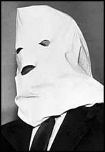
Igor Sergeyevich Gouzenko was a cipher clerk for the Soviet embassy to Canada in Ottawa, Ontario. He defected on 5 September 1945, three days after the end of World War II, with 109 documents on the USSR's espionage activities in the West. This forced Canada's Prime Minister Mackenzie King to call a Royal Commission to investigate espionage in Canada.

The Fairmont Château Laurier is a 660,000-square-foot (61,000 m2) hotel with 429 guest rooms in the city's downtown core of Ottawa, Ontario, Canada, located near the intersection of Rideau Street and Sussex Drive and designed in a French Gothic Revival Châteauesque style to complement the adjacent Parliament buildings. The hotel is above the Rideau Canal locks and overlooks the Ottawa River. The main dining room overlooks Major's Hill Park. The reception rooms include the Wedgewood-blue Adam Room; the Laurier Room defined by Roman columns; the Empire-style ballroom and the Drawing Room featuring cream and gold plaster ornament. The hotel was designated a national historic site in 1980.

Bank Street is the major commercial north-south street in Ottawa, Ontario, Canada. It runs south from Wellington Street in downtown Ottawa, south through the neighbourhoods of Centretown, The Glebe, Old Ottawa South, Alta Vista, Hunt Club, and then through the villages of Blossom Park, Leitrim, South Gloucester, Greely, Metcalfe, Spring Hill, and Vernon before exiting the city limits at Belmeade Road.

Laurier Avenue(French: Avenue Laurier) is a central east west street running through Ottawa, Ontario, Canada. Originally known as "Maria Street" and "Theodore Street", it was renamed in honour of Canadian Prime Minister Sir Wilfrid Laurier. Laurier House, the residence of Prime Ministers Laurier and William Lyon Mackenzie King, is located at the corner of Laurier Avenue East and Chapel Street.
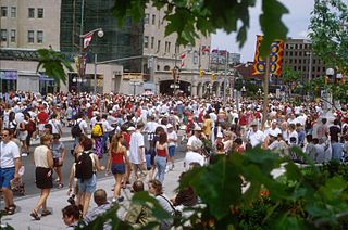
Wellington Street is a major street in Ottawa, Ottawa, Canada. The street is notable for being the main street of the Parliamentary Precinct of the Parliament of Canada. It is one of the first two streets laid out in Bytown in 1826. The street runs from Vimy Place, just west of Booth Street, to the Rideau Canal where it connects with Rideau Street and delimits the northern border of the downtown core. It is named after the Duke of Wellington, in recognition of his role in the creation of the Rideau Canal, and therefore of Ottawa.

Somerset Street is a street in Ottawa, Ontario, Canada. It is divided into Somerset Street East and Somerset Street West by the Rideau Canal.

The East Memorial Building and West Memorial Building are a pair of government buildings in Ottawa, Ontario, Canada.

The Embassy of Russia in Canada is the Russian embassy in Ottawa, Ontario, Canada, It is located at 285 Charlotte Street, at the eastern terminus of Laurier Avenue built by W.E. Noffke. To the south it looks out on Strathcona Park while to the east it looks out on the Rideau River. Russia also maintains consulates in Toronto and Montreal.
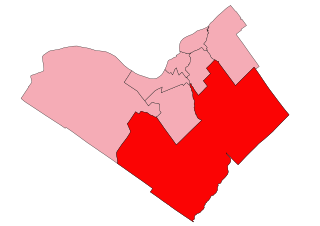
Carleton is a federal electoral district in Ontario, Canada, represented in the House of Commons of Canada from 1867 to 1968 and since 2015. It was represented in the Legislative Assembly of Upper Canada from 1821 to 1840 and in the Legislative Assembly of the Province of Canada from 1841 until 1866.
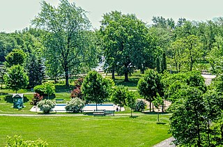
Strathcona Park is a large park in Ottawa, Ontario, Canada. It lies on the west bank of the Rideau River and marks the eastern edge of the Sandy Hill neighbourhood.

Confederation Park(French: Parc de la Confédération) is a public park and National Historic Site of Canada, located in downtown Ottawa, Ontario, Canada. It is bordered on the south by Laurier Avenue and Ottawa City Hall; on the east by the Rideau Canal and National Defence Headquarters; on the north by the Mackenzie King Bridge, the Rideau Centre, and the National Arts Centre; and, to the west, by Elgin Street and the Lord Elgin Hotel.

Britannia is a group of neighbourhoods in Bay Ward in the west end of Ottawa, Ontario, Canada. It is located on the Ottawa River across from Aylmer, Quebec, adjacent to its namesake, Britannia Bay, north of Richmond Road, west of the Sir John A. Macdonald Parkway and east of Boyce Avenue. The total population of this area was 6,692 as of the 2016 census. The area constituted a municipal ward from 1973 to 1994.
Montgomery Place is a post World War II community erected for veterans outside Saskatoon, Saskatchewan, which consists primarily of residential homes. It was amalgamated within the city of Saskatoon in 1956, and is now a National Historic Site. Montgomery Place has an average household size of 3.2 persons, and homeownership is at 93.7%. According to MLS data, the average sale price of a home as of 2013 was $403,840. It was named in honour of Field Marshal The 1st Viscount Montgomery of Alamein, the famous Ulster Scots commander in the British Army during the Second World War.

Dundonald is a neighbourhood located in the northwest corner of Saskatoon, Saskatchewan. The neighbourhood was built in the 1980s, and served as the last development of the northwest corner of the city, prior to the development of Hampton Village. Dundonald is surrounded by a large landscaped park, with a storm pond. In comparison, the neighbourhood of Dundonald with a 2001 census population of 5,285 is larger than the Saskatchewan city of Melville which had a population of 4,149 in 2006, and 4,453 in 2001 and Dundonald is also larger than the provincial city of Humboldt which was 4,998 in 2006, and 5,161 in 2001. In Saskatchewan rural towns must maintain a population above 5,000 to apply for city status. According to MLS data, the average sale price of a home as of 2013 was $298,832.

Circle Drive is a major road constructed as a ring road in Saskatoon, Saskatchewan, Canada. Its route constitutes both part of the Yellowhead Highway and Highway 11, signed as both along the entire length. It was first conceived in 1913 by the city commissioner and completed exactly 100 years later in 2013. Most of the route is a fully-controlled access freeway, however the segment between Airport Drive and Millar Avenue has at-grade intersections.
The Plaza Bridge in Ottawa, Ontario, Canada, is an automotive and pedestrian bridge that crosses the Rideau Canal just south of the Ottawa locks. It joins Wellington Street and Elgin Street in the Downtown core to the west with Rideau Street to the east. The Chateau Laurier abuts the bridge at the east end, while Parliament Hill is just beyond the west end. It is the northernmost bridge over the canal, just north of the Mackenzie King Bridge.

The Iron Curtain is a 1948 American thriller film starring Dana Andrews and Gene Tierney, directed by William Wellman. The film was based on the memoirs of Igor Gouzenko. Principal photography was done on location in Ottawa, Ontario, Canada by Charles G. Clarke. The film was later re-released as Behind the Iron Curtain.
The Kellock–Taschereau Commission was a royal commission appointed by Prime Minister William Lyon Mackenzie King on behalf of the Government of Canada under Order in Council PC 411 on February 5, 1946.
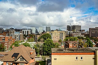
Centretown is a neighbourhood in Somerset Ward, in central Ottawa, Ontario, Canada. It is defined by the city as "the area bounded on the north by Gloucester Street and Lisgar Street, on the east by the Rideau Canal, on the south by the Queensway freeway and on the west by Bronson Avenue." Traditionally it was all of Ottawa west of the Rideau Canal, while Lower Town was everything to the east. For certain purposes, such as the census and real estate listings, the Golden Triangle and/or Downtown Ottawa is included in Centretown and it is considered part of Centretown by the Centretown Citizens Community Association as well as being used in this way in casual conversation.

Operation Manhunt is a 1954 American drama film directed by Jack Alexander and written by Paul Monash. The film stars Harry Townes, Irja Jensen, Jacques Aubuchon, Robert Goodier, Albert Miller and Caren Shaffer. It is a fictionalized story about the aftermath of the defection of Igor Gouzenko, a former Soviet cipher clerk who revealed the operations of Soviet agents on Canadian soil. The film was released on October 4, 1954, by United Artists.


