Dune 45

Last updated

View of Dune 45 Duna 45, Sossusvlei, Namibia, 2018-08-06, DD 008.jpg
View of Dune 45
Dune 45 sunset view Sunset at Dune 45, Sossovlei.jpg
Dune 45 sunset view

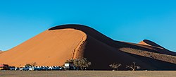
Dune 45 is a star dune in the Sossusvlei area of the Namib Desert in Namibia. Its name comes from the fact that it is at the 45th kilometre of the road that connects the Sesriem gate and Sossusvlei. Standing over 170 m, [1] it is composed of 5-million-year-old sand that is detritus accumulated by the Orange River from the Kalahari Desert and then blown here.[ need quotation to verify ]

Because it is near the road the dune is often photographed, particularly early and late in the day when one side of the dune is in shadow. It is often climbed by visitors to Sossusvlei.

Related Research Articles

<span class="mw-page-title-main">Dune</span> Hill of loose sand built by aeolian processes or the flow of water

A dune is a landform composed of wind- or water-driven sand. It typically takes the form of a mound, ridge, or hill. An area with dunes is called a dune system or a dune complex. A large dune complex is called a dune field, while broad, flat regions covered with wind-swept sand or dunes, with little or no vegetation, are called ergs or sand seas. Dunes occur in different shapes and sizes, but most kinds of dunes are longer on the stoss (upflow) side, where the sand is pushed up the dune, and have a shorter slip face in the lee side. The valley or trough between dunes is called a dune slack.

<span class="mw-page-title-main">Kalahari Desert</span> Semi-arid sandy savanna in Southern Africa

The Kalahari Desert is a large semi-arid sandy savanna in Southern Africa extending for 900,000 square kilometres (350,000 sq mi), covering much of Botswana, as well as parts of Namibia and South Africa.

<span class="mw-page-title-main">Geography of Namibia</span>

At 824,292 km2 (318,261 sq mi), Namibia is the world's thirty-fourth largest country. After Mongolia, Namibia is the second least densely populated country in the world. Namibia got its name from the Namib desert that stretches along the coast of the Atlantic. It is also known for its wildlife.

<span class="mw-page-title-main">Namib</span> Desert in Southern Africa

The Namib is a coastal desert in Southern Africa. According to the broadest definition, the Namib stretches for more than 2,000 kilometres (1,200 mi) along the Atlantic coasts of Angola, Namibia, and northwest South Africa, extending southward from the Carunjamba River in Angola, through Namibia and to the Olifants River in Western Cape, South Africa. The Namib's northernmost portion, which extends 450 kilometres (280 mi) from the Angola-Namibia border, is known as Moçâmedes Desert, while its southern portion approaches the neighboring Kalahari Desert. From the Atlantic coast eastward, the Namib gradually ascends in elevation, reaching up to 200 kilometres (120 mi) inland to the foot of the Great Escarpment. Annual precipitation ranges from 2 millimetres (0.079 in) in the aridest regions to 200 millimetres (7.9 in) at the escarpment, making the Namib the only true desert in southern Africa. Having endured arid or semi-arid conditions for roughly 55–80 million years, the Namib may be the oldest desert in the world and contains some of the world's driest regions, with only western South America's Atacama Desert to challenge it for age and aridity benchmarks.

<span class="mw-page-title-main">Namib-Naukluft National Park</span> National park in Namibia

The Namib-Naukluft Park is a national park in western Namibia, situated between the coast of the Atlantic Ocean and the edge of the Great Escarpment. It encompasses part of the Namib Desert, the Naukluft mountain range, and the lagoon at Sandwich Harbour. The best-known area of the park and one of the main visitor attractions in Namibia is Sossusvlei, a clay pan surrounded by dunes, and Sesriem, a small canyon of the Tsauchab. The desert research station of Gobabeb is situated within the park.

<span class="mw-page-title-main">Sandboarding</span> Boardsport

Sandboarding is a boardsport and extreme sport similar to snowboarding that involves riding across or down a sand dune while standing on a board, either with both feet strapped in or while standing loose, without bindings. Sandboarding can also be practised sitting down or lying on the belly or the back. It typically involves a sandboard, although it is also possible to use sleds, surfboards, a skateboard deck, or snowboards.

<span class="mw-page-title-main">Swakopmund</span> City in Erongo, Namibia

Swakopmund is a city on the coast of western Namibia, 352 km (219 mi) west of the Namibian capital Windhoek via the B2 main road. It is the capital of the Erongo administrative district. As of 2011, the town had 44,725 inhabitants and 196 km2 (76 sq mi) of land.

Big Daddy may refer to:

<span class="mw-page-title-main">Kaokoveld</span> Desert ecoregion in Angola and Namibia

The Kaokoveld Desert is a coastal desert of northern Namibia and southern Angola.

<i>Vachellia erioloba</i> Species of tree native to southern Africa

Vachellia erioloba, the camel thorn, also known as the giraffe thorn, mokala tree, or Kameeldoring in Afrikaans, still more commonly known as Acacia erioloba, is a tree of southern Africa in the family Fabaceae. Its preferred habitat is the deep dry sandy soils in parts of South Africa, Botswana, the western areas of Zimbabwe and Namibia. It is also native to Angola, south-west Mozambique, Zambia and Eswatini. The tree was first described by Ernst Heinrich Friedrich Meyer and Johann Franz Drège in 1836. The camel thorn is a protected tree in South Africa.

<span class="mw-page-title-main">Langstrand</span> Holiday resort in Erongo Region, Namibia

Langstrand is a small beach resort on the Atlantic coast in western Namibia. Langstrand and its neighboring sister resort Dolfynstrand lies between Walvis Bay and Swakopmund.

<span class="mw-page-title-main">Solitaire, Namibia</span> Place in Khomas Region, Namibia

Solitaire is a small settlement in the Khomas Region of central Namibia near the Namib-Naukluft National Park. It currently features the only gasoline station, bakery, cafe, and the only general dealer between the dunes at Sossusvlei and the coast at Walvis Bay, as well as on the road to the capital Windhoek. Solitaire belongs to the Windhoek Rural electoral constituency.

<span class="mw-page-title-main">Sossusvlei</span> Salt and clay pan in the Namib Desert,  Namibia

Sossusvlei is a salt and clay pan surrounded by high red dunes, located in the southern part of the Namib Desert, in the Namib-Naukluft National Park of Namibia. The name "Sossusvlei" is often used in an extended meaning to refer to the surrounding area. These landmarks are some of the major visitor attractions of Namibia.

<span class="mw-page-title-main">Tsauchab</span> River in central Namibia

The Tsauchab is an ephemeral river in the Hardap Region of central Namibia. Its source is in the southern Naukluft Mountains, from where it flows westwards through the Namib-Naukluft National Park into Sossusvlei, an endorheic basin. The lower river has in the past had a slightly different courses and also formed two other basins, the Deadvlei and the Hiddenvlei.

<span class="mw-page-title-main">Sesriem</span> Place in Hardap Region, Namibia

Sesriem is a small settlement in the Namib Desert, in the Hardap Region of Namibia, close to the southern end of the Naukluft Mountains. It is especially known because the "Sesriem gate" is the main access point to the Namib-Naukluft National Park for visitors entering the park to visit the nearby tourist attraction of Sossusvlei. As many "settlements" in the Namib, Sesriem is essentially a filling station with basic services such as public telephones and a couple of small kiosks where travellers can get general supplies such as food and water. In the surroundings of Sesriem there are several accommodation establishments, such as a few lodges and 24 campsites.

<span class="mw-page-title-main">Desert rain frog</span> Species of amphibian

The desert rain frog, web-footed rain frog, or Boulenger's short-headed frog is a species of frog in the family Brevicipitidae. It is found in Namibia and South Africa. Its natural habitat is the narrow strip of sandy shores between the sea and the sand dunes. It is threatened by habitat loss by such factors as mining and tourism.

<span class="mw-page-title-main">Tourism in Namibia</span> Economic sector in Namibia

Tourism in Namibia is a major industry, contributing N$7.2 billion to the country's gross domestic product. Annually, over one million travelers visit Namibia, with roughly one in three coming from South Africa, then Germany and finally the United Kingdom, Italy and France. The country is among the prime destinations in Africa and is known for ecotourism which features Namibia's extensive wildlife.

<span class="mw-page-title-main">Tsau ǁKhaeb Sperrgebiet National Park</span> Diamond mining area in the Namib Desert, southwestern Namibia

The Tsau ǁKhaeb (Sperrgebiet) National Park, formerly known as Sperrgebiet is a diamond mining area in southwestern Namibia, in the Namib Desert. It spans the Atlantic Ocean-facing coast from Oranjemund on the border with South Africa, to around 72 kilometres (45 mi) north of Lüderitz, a distance of 320 km (200 mi) north. It extends to around 100 km (62 mi) inland, and its total area of 26,000 km2 (10,000 sq mi), makes up three percent of Namibia's land mass. However, mining only takes place in five percent of the Sperrgebiet, with most of the area acting as a buffer zone. Members of the public are banned from entering most of the area, despite the creation of a national park there in 2004.

<span class="mw-page-title-main">Deadvlei</span> Clay pan in the Namib-Naukluft Park in Namibia

Deadvlei is a white clay pan located near the more famous salt pan of Sossusvlei, in a valley between the dunes in the Namib-Naukluft Park in Namibia. Also written DeadVlei or Dead Vlei, its name means "dead marsh". The pan also is referred to as "Dooie Vlei" which is the Afrikaans name. There are many references to the site on the Internet, its name often being translated erroneously in terms such as "dead valley"; a vlei is not a valley. Nor is the site a valley; the pan is a desiccated vlei.

<span class="mw-page-title-main">Tsaris Pass</span> Mountain pass in Namibia

The Tsaris Pass is a mountain pass west of Maltahöhe, Namibia, on the C19 road through the Tsaris Mountains in the Namib Desert in the direction of Sossusvlei, Sesriem, and Solitaire. Although the road has a grade of 1:18, it is unsuitable for trailers.

References

  1. "die höchsten Dünen der Welt in Namibia". Sossusvlei (in German). 23 May 2012. Retrieved 19 September 2023.

24°43′S15°28′E / 24.717°S 15.467°E / -24.717; 15.467