At 824,292 km2 (318,261 sq mi), Namibia is the world's thirty-fourth largest country. After Mongolia, Namibia is the second least densely populated country in the world. Namibia got its name from the Namib desert that stretches along the coast of the Atlantic. It is also known for its wildlife.

The Namib is a coastal desert in Southern Africa. According to the broadest definition, the Namib stretches for more than 2,000 kilometres (1,200 mi) along the Atlantic coasts of Angola, Namibia, and South Africa, extending southward from the Carunjamba River in Angola, through Namibia and to the Olifants River in Western Cape, South Africa. The Namib's northernmost portion, which extends 450 kilometres (280 mi) from the Angola-Namibia border, is known as Moçâmedes Desert, while its southern portion approaches the neighboring Kalahari Desert. From the Atlantic coast eastward, the Namib gradually ascends in elevation, reaching up to 200 kilometres (120 mi) inland to the foot of the Great Escarpment. Annual precipitation ranges from 2 millimetres (0.079 in) in the aridest regions to 200 millimetres (7.9 in) at the escarpment, making the Namib the only true desert in southern Africa. Having endured arid or semi-arid conditions for roughly 55–80 million years, the Namib may be the oldest desert in the world and contains some of the world's driest regions, with only western South America's Atacama Desert to challenge it for age and aridity benchmarks.

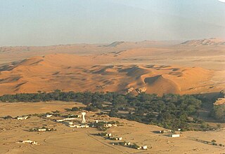
The Namib-Naukluft Park is a national park in western Namibia, situated between the coast of the Atlantic Ocean and the edge of the Great Escarpment. It encompasses part of the Namib Desert, the Naukluft mountain range, and the lagoon at Sandwich Harbour. The best-known area of the park and one of the main visitor attractions in Namibia is Sossusvlei, a clay pan surrounded by dunes, and Sesriem, a small canyon of the Tsauchab. The desert research station of Gobabeb is situated within the park.
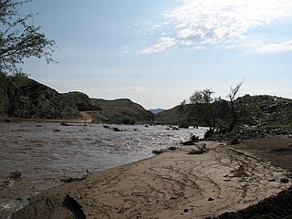
The Kuiseb River is an ephemeral river in western-central Namibia. Its source is in the Khomas Highland west of Windhoek. From there it flows westwards through the Namib-Naukluft National Park and the Namib desert to Walvis Bay. Several settlements of the Topnaar people are on the banks of the lower Kuiseb, for instance Homeb, Sandfontein, Rooibank, and Utuseb. Inflows of the Kuiseb are Gomab, Ojab, Chausib, Gaub, Koam, Nausgomab and Goagos.
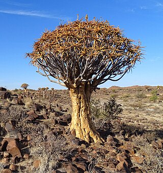
Aloidendron dichotomum, formerly Aloe dichotoma, the quiver tree or kokerboom, is a tall, branching species of succulent plant, indigenous to Southern Africa, specifically in the Northern Cape province of South Africa, and parts of Southern Namibia.

Vachellia erioloba, the camel thorn, also known as the giraffe thorn, mokala tree, or Kameeldoring in Afrikaans, still more commonly known as Acacia erioloba, is a tree of southern Africa in the family Fabaceae. Its preferred habitat is the deep dry sandy soils in parts of South Africa, Botswana, the western areas of Zimbabwe and Namibia. It is also native to Angola, south-west Mozambique, Zambia and Eswatini. The tree was first described by Ernst Heinrich Friedrich Meyer and Johann Franz Drège in 1836. The camel thorn is a protected tree in South Africa.

Dune 45 is a star dune in the Sossusvlei area of the Namib Desert in Namibia. Its name comes from the fact that it is at the 45th kilometre of the road that connects the Sesriem gate and Sossusvlei. Standing over 170 m, it is composed of 5-million-year-old sand that is detritus accumulated by the Orange River from the Kalahari Desert and then blown here..

Solitaire is a small settlement in the Khomas Region of central Namibia near the Namib-Naukluft National Park. It currently features the only gasoline station, bakery, cafe, and the only general dealer between the dunes at Sossusvlei and the coast at Walvis Bay, as well as to the capital Windhoek. Solitaire belongs to the Windhoek Rural electoral constituency.
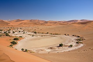
Sossusvlei is a salt and clay pan surrounded by high red dunes, located in the southern part of the Namib Desert, in the Namib-Naukluft National Park of Namibia. The name "Sossusvlei" is often used in an extended meaning to refer to the surrounding area. These landmarks are some of the major visitor attractions of Namibia.

Sandwich Harbour, also known as Sandwich Bay, Sandvishawe, Sandvisbaai and Sandfisch Bai is an area on the Atlantic coast of Namibia that includes a bay in the north and a lagoon at the southern end. Sandwich Harbour might have been named after an English whaling ship, the Sandwich, which worked during the 1780s, or the name may be a corruption of the German word "sandfische", a species of shark found in the area. Formerly the bay was a moderately-sized commercial port based around whaling and small-scale fishing, but it is now best known for its birdlife in the lagoon to the south of the bay.
Articles related to Namibia include:

The Tsauchab is an ephemeral river in the Hardap Region of central Namibia. Its source is in the southern Naukluft Mountains, from where it flows westwards through the Namib-Naukluft National Park into Sossusvlei, an endorheic basin. The lower river has in the past had a slightly different courses and also formed two other basins, the Deadvlei and the Hiddenvlei.

The wildlife of Namibia is composed of its flora and fauna. Namibia's endangered species include the wild dog, black rhino, oribi and puku.

Tourism in Namibia is a major industry, contributing N$7.2 billion to the country's gross domestic product. Annually, over one million travelers visit Namibia, with roughly one in three coming from South Africa, then Germany and finally the United Kingdom, Italy and France. The country is among the prime destinations in Africa and is known for ecotourism which features Namibia's extensive wildlife.

Deadvlei is a white clay pan located near the more famous salt pan of Sossusvlei, in a valley between the dunes in the Namib-Naukluft Park in Namibia. Also written DeadVlei or Dead Vlei, its name means "dead marsh". The pan also is referred to as "Dooie Vlei" which is the Afrikaans name. There are many references to the site on the Internet, its name often being translated erroneously in terms such as "dead valley"; a vlei is not a valley. Nor is the site a valley; the pan is a desiccated vlei.

The Namib Desert horse is a feral horse found in the Namib Desert of Namibia. It is the only feral herd of horses residing in Africa, with a population ranging between 90 and 150. The Namib Desert horse is athletic in appearance, resembling the European light riding horses from which it probably descends, and usually dark in color. Despite the harsh environment in which they live, the horses are generally in good condition, except during times of extreme drought. The horses have been the subject of several population studies, which have given significant insight into their population dynamics and ability to survive in desert conditions.

Spreetshoogte Pass is a mountain pass in central Namibia, connecting the Namib Desert with the Khomas Highland by traversing the Great Escarpment, a geological feature of much of the southern part of the African continent. With gradients between 1:4.5 and 1:6 it is the steepest pass in Namibia, as well as the one straddling the biggest elevation difference, descending almost 1,000 metres (3,300 ft) within 4 kilometres (2.5 mi) of road. The top of the pass features a rest place from which there are views into the adjacent Namib.
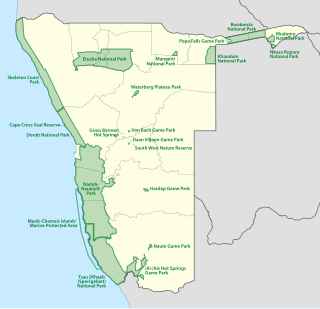
The protected areas of Namibia include its national parks and reserves. With the 2010 declaration of Dorob National Park, Namibia became the first and only country to have its entire coastline protected through a national parks network. Protected areas are subdivided into game reserves and/or nature reserves, such as special protected area, wilderness areas, natural areas, and development areas. There are also recreation reserves. Facilities in the national parks are operated by Namibia Wildlife Resorts. Over 19% of Namibia is protected, an area of some 130,000 square kilometres. However, the Ministry of Environment & Tourism auctions limited hunting rights within its protected areas. The Namibia Nature Foundation, an NGO, was established in 1987 to raise and administer funds for the conservation of wildlife and protected area management. Communal Wildlife Conservancies in Namibia help promote sustainable natural resource management by giving local communities rights to wildlife management and tourism.

The geology of Namibia encompasses rocks of Paleoproterozoic, Mesoproterozoic and Neoproterozoic and Paleozoic to Cenozoic age. About 46% of the countryʼs surface are bedrock exposure, while the remainder is covered by the young overburden sediments of the Kalahari and Namib deserts.