The Sossusvlei panAerial view of Sossusvlei (2017)Pronunciation of SossusvleiSatellite image of Sossusvlei (Landsat 7)
Sossusvlei (sometimes written Sossus Vlei) is a salt and clay pan[1] surrounded by high red dunes, located in the southern part of the Namib Desert, in the Namib-Naukluft National Park of Namibia. The name "Sossusvlei" is often used in an extended meaning to refer to the surrounding area (including other neighbouring vleis such as Deadvlei and other high dunes). These landmarks are some of the major visitor attractions of Namibia.[2]
The name "Sossusvlei" is of mixed origin and roughly means "dead-end marsh". Vlei is the Afrikaans word for "marsh", while "sossus" is Nama for "no return" or "dead end". Sossusvlei owes this name to the fact that it is an endorheicdrainage basin (i.e., a drainage basin without outflows) for the ephemeral Tsauchab River.
Environment
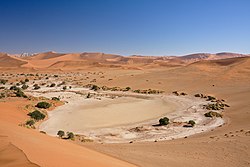
The Sossusvlei area. The Sossusvlei pan proper is the flat ellipse in a lighter shade of color seen behind the dune in the foreground (mostly on its right)
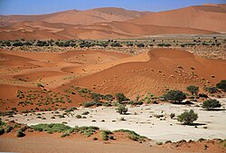
The Sossusvlei area forms part of a wider region of the southern Namib Desert with homogeneous features (about 32.000km²) extending between the Koichab and Kuiseb rivers. This area is characterized by high sand dunes in different shades of orange - the colour an indication of a high concentration of iron, after being exposed to the process of oxidation over many years. The older the dunes, the more intense the reddish colour. These dunes are among the highest in the world; many of them higher than 200 metres, the highest being the one nicknamed Big Daddy, about 325 metres high.
Traces in the sand, left by insects and other small animals
The highest and more stable dunes are partially covered with relatively rich vegetation, which is mainly watered by a number of underground and ephemeral rivers that seasonally flood the pans, creating marshes that are locally known as vleis. When dried up, these pans look almost white in color, due to the high concentration of salt. Another important source of water for Sossusvlei is the moisture from the daily morning fogs that enter the desert from the Atlantic Ocean.
Fauna in the Sossusvlei area is surprisingly rich in variety. It mostly comprises small animals that can survive with little water, including a number of arthropods, small reptiles, and small mammals (such as rodents or jackals). Bigger animals include antelopes (mainly oryxes and springboks) and ostriches. On the rare occasion that the pans flood, several migrant bird species might be found in the water. Much of the Sossusvlei and Namib fauna is endemic and highly adapted to the specific conditions of the Namib, for instance, the Namib Desert Beetle which has developed a technique for collecting water from the early morning fog with the help of the specially adapted bumps on its back.
Climate
Sossusvlei has a hot desert climate. The annual mean average temperature is 24°C. In winter, the nighttime lows are around 10°C, while in summer temperatures often reach up to 40°C. Being situated in the Namib desert, there is a large variation between day and night temperatures. Rain is a rare phenomenon.
Climate data for Sesriem, Namibia (2010–2017 averages)
Access to the Sossusvlei area of the Namib-Naukluft National Park is from the Sesriem gate, which is located in the surroundings of the eponymous canyon. From Sesriem, a 60km tarmac road leads to Sossusvlei proper.
Elim Dune
The Elim Dune is a high and relatively isolated dune located 5km past the Sesriem gate, on a branch of the main road connecting Sesriem to Sossusvlei. The dune takes its name from a farm that used to be in the area before the National Park was established.
Dune 45 is so called because it lies 45km past Sesriem on the road to Sossusvlei. It is 80 meters high and it is composed of 5-million-year-old sands.
Sossusvlei
Sossusvlei seen from the dunesSossusvlei during an occasional flood
Sossusvlei is about 66km past the Sesriem gate. The last 6km can only be traversed with 4WD vehicles as the metalled road ends and sand begins (the place where the metalled road ends is known as "2x4 parking" as any non-4WD vehicle must stop there). Sossusvlei is a clay pan, of roughly elliptical shape, covered in a crust of salt-rich sand.[1] While the pan has been shaped over time by the Tsauchab river, the actual flooding of the pan is a relatively rare event, and sometimes several years pass between one flood and the next one. The river is dry most of the year, and even when it is not, it carries relatively little water to the vlei. The vlei is surrounded by high orange-reddish dunes, partially covered by a vegetation comprising grass, bushes, and some trees (mostly of species Vachellia erioloba).
Big Daddy
Big Daddy is the highest dune in the Sossusvlei area, at about 325 meters. Big Daddy is located past Sossusvlei proper, near Deadvlei. It faces another very high dune known as "Big Mama".
Deadvlei is another clay pan, about 2km from Sossusvlei. A notable feature of Deadvlei is that it used to be an oasis with several camelthorn trees; afterwards, the river that watered the oasis changed its course. The pan is thus punctuated by blackened, dead camelthorn trees, in vivid contrast to the shiny white of the salty floor of the pan and the intense orange of the dunes. This creates a particularly fascinating and surrealistic landscape, that appears in innumerable pictures and has been used as a setting for films and videos.
Hiddenvlei
Hiddenvlei (or Hidden Vlei) is another vlei in the Sossusvlei area. It is 4km from the 2×4 parking, and it is the least visited.
Lithified dunes
Lithified dunes are sand dunes that have solidified to rock and are found in several places in the Sossusvlei area.
Since Sossusvlei is possibly the foremost attraction of Namibia, much has been done by the Namibian authorities to support and facilitate tourism in the area. The asphalt road was built in the early 2000s (decade) to connect Sesriem and Sossusvlei's 2x4 parking is one of the very few non-urban metalled roads in Namibia. Numerous places of accommodation are found along the border of the National Park, between Sesriem and the nearest settlement, Solitaire. Recently, accommodation has been built inside the park. It is also possible to take scenic flights over the dunes, either with small planes (mainly from Swakopmund and Walvis Bay) or in hot air balloons (departing from Sesriem in the morning).
In popular culture
As a consequence of its fascinating and surrealistic landscapes, Sossusvlei is one of the most photographed places in Subsaharan Africa. The area has been the setting of a number of commercials, music videos, and movies, especially of the fantasy genre; one of the most well-known examples is the psychological thrillerThe Cell (2000), where the Sossusvlei landscape is used to represent an oneiricvirtual reality.
The nonverbal documentary Samsara depends on a number of shots of the desert for subtle spiritual commentary. Other movies with scenes shot in Sossusvlei include The Fall and Steel Dawn.[1]
This page is based on this Wikipedia article Text is available under the CC BY-SA 4.0 license; additional terms may apply. Images, videos and audio are available under their respective licenses.