Deadvlei

Last updated
Dead Vachellia erioloba in Deadvlei Dead Vlei 4.jpg
Dead Vachellia erioloba in Deadvlei

Deadvlei is a white clay pan located near the more famous salt pan of Sossusvlei, in a valley between the dunes in the Namib-Naukluft Park in Namibia. Also written DeadVlei or Dead Vlei, its name means "dead marsh" (from English dead, and Afrikaans vlei , meaning lake or marsh). The pan also is referred to as "Dooie Vlei" which is the Afrikaans name. There are many references to the site on the Internet, its name often being translated erroneously in terms such as "dead valley"; a vlei is not a valley (which in Afrikaans is "vallei"). [1] Nor is the site a valley; the pan is a desiccated vlei.

Contents

Dead Vlei has been claimed to be surrounded by the highest sand dunes in the world, the highest reaching 300–400 meters (350m on average), named "Big Daddy" or "Crazy Dune", resting on a sandstone terrace.

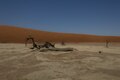
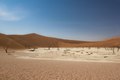
The clay pan was formed after rainfall, when the Tsauchab river flooded, creating temporary shallow pools where the abundance of water allowed camel thorn trees to grow. When the climate changed, drought hit the area, and sand dunes encroached on the pan, which blocked the river from the area.

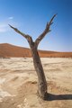
The trees died as there was no longer enough water to survive. However, some species of plants remain, such as salsola and clumps of nara, adapted to surviving off the morning mist and very rare rainfall. The remaining skeletons of the trees, which are believed to have died 600–700 years ago (ca. 1340-1430), are now black and scorched by the intense heat. [2] [3] Though not petrified, the wood has not decomposed because the area is so dry. [4]

Films partly shot there include The Cell , The Fall , Ghajini and Ayan .

Related Research Articles

<span class="mw-page-title-main">Kalahari Desert</span> Semi-arid sandy savanna in Southern Africa

The Kalahari Desert is a large semi-arid sandy savanna in Southern Africa extending for 900,000 square kilometres (350,000 sq mi), covering much of Botswana, as well as parts of Namibia and South Africa.

<span class="mw-page-title-main">Namibia</span> Country in Southern Africa

Namibia, officially the Republic of Namibia, is a country in Southern Africa. Its western border is the Atlantic Ocean. It shares land borders with Zambia and Angola to the north, Botswana to the east and South Africa to the south and east. Although it does not border Zimbabwe, less than 200 metres of the Botswanan right bank of the Zambezi River separates the two countries. Its capital and largest city is Windhoek.

<span class="mw-page-title-main">Geography of Namibia</span>

At 824,292 km2 (318,261 sq mi), Namibia is the world's thirty-fourth largest country. After Mongolia, Namibia is the second least densely populated country in the world. Namibia got its name from the Namib desert that stretches along the coast of the Atlantic. It is also known for its wildlife.

The Younger Dryas, which occurred circa 12,900 to 11,700 years BP, was a return to glacial conditions which temporarily reversed the gradual climatic warming after the Last Glacial Maximum, which lasted from circa 27,000 to 20,000 years BP. The Younger Dryas was the last stage of the Pleistocene epoch that spanned from 2,580,000 to 11,700 years BP and it preceded the current, warmer Holocene epoch. The Younger Dryas was the most severe and longest lasting of several interruptions to the warming of the Earth's climate, and it was preceded by the Late Glacial Interstadial, an interval of relative warmth that lasted from 14,670 to 12,900 BP.

<span class="mw-page-title-main">Namib</span> Desert in Southern Africa

The Namib is a coastal desert in Southern Africa. According to the broadest definition, the Namib stretches for more than 2,000 kilometres (1,200 mi) along the Atlantic coasts of Angola, Namibia, and northwest South Africa, extending southward from the Carunjamba River in Angola, through Namibia and to the Olifants River in Western Cape, South Africa. The Namib's northernmost portion, which extends 450 kilometres (280 mi) from the Angola-Namibia border, is known as Moçâmedes Desert, while its southern portion approaches the neighboring Kalahari Desert. From the Atlantic coast eastward, the Namib gradually ascends in elevation, reaching up to 200 kilometres (120 mi) inland to the foot of the Great Escarpment. Annual precipitation ranges from 2 millimetres (0.079 in) in the aridest regions to 200 millimetres (7.9 in) at the escarpment, making the Namib the only true desert in southern Africa. Having endured arid or semi-arid conditions for roughly 55–80 million years, the Namib may be the oldest desert in the world and contains some of the world's driest regions, with only western South America's Atacama Desert to challenge it for age and aridity benchmarks.

<span class="mw-page-title-main">Loess</span> Sediment of accumulated wind-blown dust

A loess is a clastic, predominantly silt-sized sediment that is formed by the accumulation of wind-blown dust. Ten percent of Earth's land area is covered by loesses or similar deposits.

<span class="mw-page-title-main">Namib-Naukluft National Park</span> National park in Namibia

The Namib-Naukluft Park is a national park in western Namibia, situated between the coast of the Atlantic Ocean and the edge of the Great Escarpment. It encompasses part of the Namib Desert, the Naukluft mountain range, and the lagoon at Sandwich Harbour. The best-known area of the park and one of the main visitor attractions in Namibia is Sossusvlei, a clay pan surrounded by dunes, and Sesriem, a small canyon of the Tsauchab. The desert research station of Gobabeb is situated within the park.

<span class="mw-page-title-main">Last Glacial Period</span> Period of major glaciations of the northern hemisphere (115,000–12,000 years ago)

The Last Glacial Period (LGP), also known colloquially as the Last Ice Age or simply Ice Age, occurred from the end of the Eemian to the end of the Younger Dryas, encompassing the period c. 115,000 – c. 11,700 years ago.

Kathu is a town in South Africa, and the iron ore capital of the Northern Cape province. Its name means "town under the trees", after the Camel Thorn forest it is situated in. The phrase "the town under the trees" was coined by an engineer working in the town in the early-1990s as part of a tourist marketing drive, together with the accompanying graphic. It was intended to be a marketing slogan. The meaning of the word "Kathu" has anecdotically been attributed to a porridge brewed by the local population from the powder found in the pods of the Camel Thorn trees.

The Holocene Climate Optimum (HCO) was a warm period in the first half of the Holocene epoch, that occurred in the interval roughly 9,500 to 5,500 years BP, with a thermal maximum around 8000 years BP. It has also been known by many other names, such as Altithermal, Climatic Optimum, Holocene Megathermal, Holocene Optimum, Holocene Thermal Maximum, Hypsithermal, and Mid-Holocene Warm Period.

<i>Vachellia erioloba</i> Species of tree native to southern Africa

Vachellia erioloba, the camel thorn, also known as the giraffe thorn, mokala tree, or Kameeldoring in Afrikaans, still more commonly known as Acacia erioloba, is a tree of southern Africa in the family Fabaceae. Its preferred habitat is the deep dry sandy soils in parts of South Africa, Botswana, the western areas of Zimbabwe and Namibia. It is also native to Angola, south-west Mozambique, Zambia and Eswatini. The tree was first described by Ernst Heinrich Friedrich Meyer and Johann Franz Drège in 1836. The camel thorn is a protected tree in South Africa.

<span class="mw-page-title-main">Sossusvlei</span> Salt and clay pan in the Namib Desert,  Namibia

Sossusvlei is a salt and clay pan surrounded by high red dunes, located in the southern part of the Namib Desert, in the Namib-Naukluft National Park of Namibia. The name "Sossusvlei" is often used in an extended meaning to refer to the surrounding area. These landmarks are some of the major visitor attractions of Namibia.

<span class="mw-page-title-main">Swakop River</span> River in Namibia

The Swakop River is a major river in western central Namibia. Its source is in the Khomas Highland. From there it flows westwards through the town of Okahandja, the historic mission station at Gross Barmen, and the settlement of Otjimbingwe. It then crosses the Namib desert and reaches the Atlantic Ocean at Swakopmund. The Swakop is an ephemeral river; its run-off is roughly 40 million cubic metres per annum.

<span class="mw-page-title-main">Tsauchab</span> River in central Namibia

The Tsauchab is an ephemeral river in the Hardap Region of central Namibia. Its source is in the southern Naukluft Mountains, from where it flows westwards through the Namib-Naukluft National Park into Sossusvlei, an endorheic basin. The lower river has in the past had a slightly different courses and also formed two other basins, the Deadvlei and the Hiddenvlei.

<span class="mw-page-title-main">Sesriem</span> Place in Hardap Region, Namibia

Sesriem is a small settlement in the Namib Desert, in the Hardap Region of Namibia, close to the southern end of the Naukluft Mountains. It is especially known because the "Sesriem gate" is the main access point to the Namib-Naukluft National Park for visitors entering the park to visit the nearby tourist attraction of Sossusvlei. As many "settlements" in the Namib, Sesriem is essentially a filling station with basic services such as public telephones and a couple of small kiosks where travellers can get general supplies such as food and water. In the surroundings of Sesriem there are several accommodation establishments, such as a few lodges and 24 campsites.

<span class="mw-page-title-main">Subboreal</span> Climatic period of the Holocene

The Subboreal is a climatic period, immediately before the present one, of the Holocene. It lasted from 3710 to 450 BCE.

<span class="mw-page-title-main">Vlei</span> Shallow minor lake, often seasonal

A vlei is a shallow minor lake, mostly of a seasonal or intermittent nature. It even might refer to seasonal ponds or marshy patches where frogs and similar marsh dwellers breed. Commonly, vleis vary in their extent, or even in the presence or absence of water, according to the fall of rain or dryness of the season. In terms of water salinity, vleis may be freshwater, saltwater, or brackish. Over time a vlei may degrade into a salt pan or clay pan, such as Dead Vlei or Sossusvlei.

<span class="mw-page-title-main">Hoanib</span> Ephemeral seasonal river in Namibia

The Hoanib is one of the 12 ephemeral seasonal rivers in the west of Namibia, where it used to be the border between northern Damaraland and Kaokoland. Its length is 270 km. With the low population density in the area, the oasis character of the river valley and the relatively high wildlife population of the Hoanib, like in the case of the Hoarusib, its valley is one of the last true wilderness areas in Namibia. One of the last settlements of desert elephants, it is characterised by strong wind and water eroded, weathered stone deposits. Inflows of Hoanib are Aap River, Otjitaimo River, Ombonde, Ganamub, Mudorib and Tsuxub.

<span class="mw-page-title-main">African humid period</span> Holocene climate period during which northern Africa was wetter than today

The African humid period is a climate period in Africa during the late Pleistocene and Holocene geologic epochs, when northern Africa was wetter than today. The covering of much of the Sahara desert by grasses, trees and lakes was caused by changes in the Earth's axial tilt; changes in vegetation and dust in the Sahara which strengthened the African monsoon; and increased greenhouse gases. During the preceding Last Glacial Maximum, the Sahara contained extensive dune fields and was mostly uninhabited. It was much larger than today, and its lakes and rivers such as Lake Victoria and the White Nile were either dry or at low levels. The humid period began about 14,600–14,500 years ago at the end of Heinrich event 1, simultaneously to the Bølling–Allerød warming. Rivers and lakes such as Lake Chad formed or expanded, glaciers grew on Mount Kilimanjaro and the Sahara retreated. Two major dry fluctuations occurred; during the Younger Dryas and the short 8.2 kiloyear event. The African humid period ended 6,000–5,000 years ago during the Piora Oscillation cold period. While some evidence points to an end 5,500 years ago, in the Sahel, Arabia and East Africa, the end of the period appears to have taken place in several steps, such as the 4.2-kiloyear event.

<span class="mw-page-title-main">Lake Estancia</span> Prehistoric lake in New Mexico, United States

Lake Estancia was a lake formed in the Estancia Valley, central New Mexico, which left various coastal landforms in the valley. The lake was mostly fed by creek and groundwater from the Manzano Mountains, and fluctuated between freshwater stages and saltier stages. The lake had a diverse fauna, including cutthroat trout; they may have reached it during a possible past stage where it was overflowing.

References

  1. Bosman, D. B.; Van der Merwe I. W. & Hiemstra, L. W. (1984). Tweetalige Woordeboek Afrikaans-Engels. Tafelberg-uitgewers. ISBN   0-624-00533-X.
  2. Lancaster, Nicholas (2002). "How dry was dry?—Late Pleistocene palaeoclimates in the Namib Desert". Quaternary Science Reviews. 21 (7): 769–82. doi:10.1016/S0277-3791(01)00126-3.
  3. Brook, G. A., P. Srivastava, and E. Marais (2006), Characteristics and OSL minimum ages of relict fluvial deposits near Sossus Vlei, Tsauchab River, Namibia, and a regional climate record for the last 30 ka, Journal of Quaternary Science, 21(4), 347-362, doi:10.1002/jqs.977
  4. Bridgeford, P & M (2006). Touring Sesriem and Sossusvlei. Walvis Bay, Namibia: P & M Bridgeford. ISBN   99916-30-77-5.

Resources

Further reading

24°45′35″S15°17′31″E / 24.75972°S 15.29194°E / -24.75972; 15.29194