
Postbridge is a hamlet in the heart of Dartmoor in the English county of Devon. It lies on the B3212, roughly midway between Princetown and Moretonhampstead.

A listed building, or listed structure, is one that has been placed on one of the four statutory lists maintained by Historic England in England, Historic Environment Scotland in Scotland, Cadw in Wales, and the Northern Ireland Environment Agency in Northern Ireland.

The Forest of Bowland, also known as the Bowland Fells and formerly the Chase of Bowland, is an area of gritstone fells, deep valleys and peat moorland, mostly in north-east Lancashire, England, with a small part in North Yorkshire. It is a western outlier of the Pennines.

There has long been debate over the exact location of the geographical centre of the United Kingdom, and its constituent countries, due to the complexity and method of the calculation, such as whether to include offshore islands, and the fact that erosion will cause the position to change over time. There are two main methods of calculating this "centre": either as the centroid of the two-dimensional shape made by the country, or as the point farthest from the boundary of the country. These two methods give quite different answers.

Haltwhistle is a market town and civil parish in Northumberland, England, 10 miles (16 km) east of Brampton. It had a population of 3,811 at the 2011 Census.

Moulton is a village and civil parish in the West Suffolk district of Suffolk in eastern England, located close to the town of Newmarket. It pre-dates the 1086 Domesday book and, in 2005, it was estimated to have a population of 1090. 1,033 people were recorded at the 2011 census.
Dunsop Bridge is a village in the Borough of Ribble Valley, Lancashire, England, 9 miles (14 km) north-west of Clitheroe, 15 miles (24 km) south-east of Lancaster and 24.5 miles (39 km) west of Skipton. It is in the civil parish of Bowland Forest High. Historically, the village is part of the West Riding of Yorkshire, but was placed under the administration of Lancashire County Council on 1 April 1974.

Bowland Forest High is a civil parish in the Ribble Valley district of Lancashire, England, covering some 20,000 acres (80 km2) of the Forest of Bowland. According to the 2001 census, the parish had a population of 163, falling to 144 at the 2011 Census. The parish includes the settlements of Hareden, Sykes, and Dunsop Bridge. It covers Sykes Fell, Whins Brow, Croasdale Fell and Wolfhole Crag. Before 1974, it formed part of Bowland Rural District in the West Riding of Yorkshire.
The River Hodder is in Lancashire, England. It is a County Biological Heritage Site.
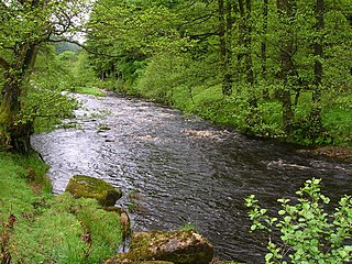
The River Dunsop is a river in the Forest of Bowland in Northern England. It flows into the River Hodder at Dunsop Bridge.

Abbeystead House is a large country house to the east of the village of Abbeystead, Lancashire, England, some 12 km south-east of Lancaster. It is recorded in the National Heritage List for England as a designated Grade II listed building.

Brennand Farm is often claimed to be the true centre of Great Britain. This is about seven kilometres north-west of Dunsop Bridge - which has the nearest BT phone box to the 'true centre'. A plaque reads “You are calling from the BT payphone that marks the centre of Great Britain”.

Browsholme Hall is a privately owned Tudor house in the parish of Bowland Forest Low in the borough of Ribble Valley, Lancashire, England. It is claimed to be the oldest surviving family home in Lancashire. Since 1954, it has been designated a Grade I listed building by English Heritage.

Ringley Old Bridge is an ancient stone bridge in Kearsley near Bolton, England which crosses the River Irwell, linking Ringley with Stoneclough. It has two large semi-circular arches, and a third smaller arch, for the tow path. It is a Grade II* structure, listed on 19 August 1986.

St Andrew's Church is in Church Street, Slaidburn, Lancashire, England. It is an active Anglican parish church in the deanery of Bowland, the archdeaconry of Craven, and the Diocese of Leeds. Its benefice is united with that of St George, Dunsop Bridge. The church is recorded in the National Heritage List for England as a designated Grade I listed building. It is notable for its "quantity of good early woodwork".

The Lord High Admiral is a Grade II* listed former public house at 43 Vauxhall Bridge Road, Pimlico, London.
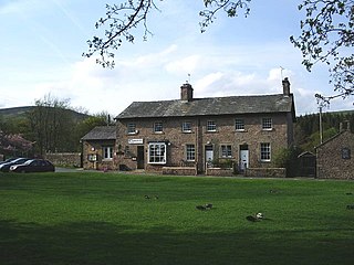
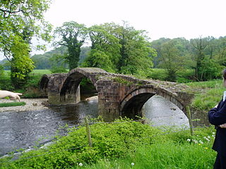
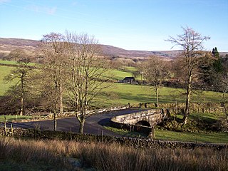
Bowland Forest High is a civil parish in Ribble Valley, Lancashire, England. It contains eight listed buildings that are recorded in the National Heritage List for England. All of the listed buildings are designated at Grade II, the lowest of the three grades, which is applied to "buildings of national importance and special interest". The parish contains the village of Dunsop Bridge, and otherwise consists of farmland and moorland. The listed buildings comprise houses, a bridge, a milestone and a boundary stone.

Conder Bridge is a Grade II listed single segmental arch bridge spanning the River Conder in the English village of Conder Green, Thurnham, Lancashire. The structure dates to the early 19th century. The bridge carries the vehicular and pedestrian traffic of the A588.
Grizedale Bridge is a Grade II listed bridge in the English parish of Over Wyresdale, Lancashire. The structure, which dates to the 19th century, carries Bakehouse Brow over the River Grizedale. A Grade II listed structure, it is in sandstone and consists of a single elliptical arch and has a solid parapet with a rounded top.

Langden Brook is a watercourse in the Trough of Bowland, Lancashire, England. A tributary of the River Hodder, its source is near the summit of Hawthornthwaite Fell, which has an elevation of 479 m (1,572 ft). From there, it flows down the fell's southern face, before turning northeast for around 2.5 miles (4.0 km). At Sykes, in Bowland Forest High, it turns southeast for about 2 miles (3.2 km), joining the Hodder a short distance later, about 0.5 miles (0.80 km) south of Dunsop Bridge.

