Durhamstown | |
---|---|
Townland | |
Coordinates: 53°39′N6°47′W / 53.650°N 6.783°W | |
Country | Ireland |
Province | Leinster |
County | County Meath |
Civil parish | Ardbraccan |
Area | |
• Total | 4.15 km2 (1.60 sq mi) |
Population (2011) [2] | 319 |
Time zone | UTC+0 (WET) |
• Summer (DST) | UTC-1 (IST (WEST)) |
Irish Grid Reference | N808684 |
Durhamstown (Irish : Baile an Dormhamaigh),[ citation needed ] known less frequently as Dormstown, is a townland outside Navan in County Meath, Ireland. In religious terms it is covered by the Roman Catholic parish of Bohermeen. Durhamstown townland lies in the civil parish of Ardbraccan, and has an area of 1,025 acres (1.602 sq mi). [1] [3]
Durhamstown, sometimes referred to as Dormstown (a form of spelling which fell into disuse by the mid 20th century), is one of twenty townlands in the civil parish of Ardbraccan and had 64 houses according to the 1911 census of Ireland. [4] As of the 2011 census, the population of the townland was 319 people. [2]
According to histories of the game of Croquet, an early set of rules of the game were compiled by an anonymous writer who described himself as "corncrake" to The Field publication on 21 August 1858. [5] "Corncrake" was revealed to be George Annesley Pollock of the Oatlands estate in Durhamstown.[ citation needed ] His "The Rules of the Oatlands Club" became a key set of rules for the game, with records revealing that the rules were used by the owners of Oatlands and Durhamstown Castle, and another nearby estate, for local competitions.[ citation needed ] The game Croquet later spread to Great Britain from Ireland. [6] Though the game spread from Ireland, the first registered set of rules were registered in Britain in 1856. [5]
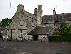
The townland's most prominent geographical formations include Faughan Hill, a small hill on the otherwise flat plains of the area on which legend claims Niall of the Nine Hostages was buried. Nearby is Durhamstown Castle, a Norman towerhouse that has been lived in for five hundred years.[ citation needed ]
Ardbraccan is an ancient place of worship in County Meath, Ireland. It is the location of the former residence of the Roman Catholic, then, after the Reformation, the Church of Ireland Bishop of Meath. it was also a place of prominence in pre-Christian Pagan history. It is approximately 52 km from Dublin via the M3 Motorway, and 4 km from Navan. Ardbraccan is in a civil parish of the same name.
Bohermeen is a Roman Catholic parish in the Irish Diocese of Meath. Its English name is a corruption of an ancient Irish language name, An Bóthar Mín, which meant the smooth road. Originally one of the five famed ancient roadways that led from the mediaeval capital of Ireland, Tara, approximately 10 miles away cut through the area. The quality of the roadway, in an era of dirt-roads, earned for it the nickname of the smooth road, An Bóthar Mín.
Fingal is a county in Ireland. It is in the province of Leinster and is part of the Eastern and Midland Region. It is one of three successor counties to County Dublin, which was disestablished for administrative purposes in 1994. Its name is derived from the medieval territory of Scandinavian foreigners that settled in the area. Fingal County Council is the local authority for the county. In 2022 the population of the county was 330,506, making it the second most populated council in Dublin and the third most populous county in the state.
Kinvara or Kinvarra is a sea port village in the southwest of County Galway, Ireland. It is located in the civil parish of Kinvarradoorus in the north of the barony of Kiltartan. Kinvarra is also an electoral division.
Shanballymore is a small village in County Cork, Ireland. It neighbours the towns of Doneraile, Kildorrery and Castletownroche, and is off the main route from Mallow to Mitchelstown. Shanballymore is part of the Cork East Dáil constituency.
Julianstown is a village in County Meath, Ireland. It is located near Drogheda on the R132 regional road. In 1641, the Battle of Julianstown was fought here during the Irish Rebellion of 1641.
Monkstown is a village in County Cork, Ireland, in the old barony of Kerrycurrihy. It lies 14 kilometres southeast of Cork city on the estuary of the River Lee, facing Great Island and looking onto Monkstown Bay. For census purposes, Monkstown is combined with the nearby town of Passage West, and the combined area has a population of approximately 5,800 residents. The village is in a townland and civil parish of the same name. The Catholic parish of Monkstown includes the nearby villages of Shanbally and Ringaskiddy.
Dunshaughlin is a town in County Meath, Ireland. A commuter town for nearby Dublin, Dunshaughlin more than tripled in population between the 1996 and 2022 censuses. The town is in a townland and civil parish of the same name.
Dunboyne is a town in County Meath, Ireland, 15 km (9 mi) north-west of Dublin city centre. It is a commuter town for Dublin. In the 20 years between the 1996 and 2016 censuses, the population of Dunboyne more than doubled from 3,080 to 7,272 inhabitants. As per the 2022 census, the population decreased slightly to 7,155. The town is in a townland and civil parish of the same name.
Durhamstown Castle is a 600-year-old towerhouse in the townland of Durhamstown of the civil parish of Ardbraccan which is in the barony (Ireland) of Lower Navan, in County Meath, Ireland. It has been inhabited continuously since 1420. It is named after a Mr. Dorream, whose family lived there in 1511, and has been converted into a guest house and restaurant.
Mountcharles is a village and townland in the south of County Donegal, Ireland. It lies 6 km from Donegal Town on the Killybegs road (N56). It is situated in the civil parish of Inver and the historic barony of Banagh. The village's name is usually pronounced locally as 'Mount-char-liss'.
Boyerstown is a townland in County Meath, Ireland. It is located off the N51 national secondary road 5 kilometres (3 mi) southwest of Navan. The M3 motorway runs through the townland.
Naul, is a village, townland, and civil parish at the northern edge of the traditional County Dublin in Ireland. The Delvin River to the north of the village marks the county boundary with County Meath. Naul civil parish is in the historic barony of Balrothery West.
Tullyallen is a village, civil parish and townland 6 km north-west of the town of Drogheda in County Louth, Ireland. It is in the historic Barony of Ferrard. It is located in the historical Boyne Valley, in the Catholic parish of Mellifont ; it is also close to Newgrange, Knowth and Dowth burial mounds, Monasterboice monastery, and to the Battle of the Boyne site.
Bellewstown is a townland and village located 8 km south of Drogheda, on the Hill of Crockafotha in County Meath in Ireland. Bellewstown townland, which is in the electoral division of Ardcath and the civil parish of Duleek, had a population of 499 as of the 2011 census. It takes its name from the Anglo-Irish Bellew family, who were the dominant local landowners from the thirteenth to the seventeenth century.
Balally, County Dublin, Ireland, is a townland and residential area between Dundrum village and the Sandyford Industrial Estate in Sandyford.
Mulhussey is a townland and village in County Meath, Ireland. It has a school, a castle with accompanying cemetery, a nearby church at the edge of the Kilcloon parish in Kilcock, and a religious antiquity, St Bridgid's Well, located in Calgath near Mulhussey.
Ashbourne is a town in County Meath, Ireland. Located about 20 km north of Dublin and close to the M2 motorway, Ashbourne is a commuter town within Greater Dublin. In the 26 years between the 1996 and 2022 census, the town tripled in population from approximately 4,900 to 15,680 inhabitants. The town is passed by the Broad Meadow Water, which comes from Ratoath and Dunshaughlin.
The barony of Castleknock is one of the baronies of Ireland. Originally part of the Lordship of Meath, it was then constituted as part of County Dublin. Today, it is in the modern county of Fingal, Ireland. The barony was originally also a feudal title, which became one of the subsidiary titles of the Viscounts Gormanston.
Castlejordan is a village and townland in County Meath, Ireland. It is located in the south of the county, close to the border with County Offaly, to the south of Kinnegad. The townland of Castlejordan has an area of approximately 2.2 square kilometres (0.85 sq mi), and had a population of 85 people as of the 2011 census.