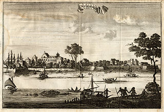
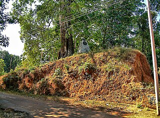
Dutch-Zamorin Conflicts

Last updated
Dutch-Zamorin Conflicts
Zamorin of Calicut.jpg
Zamorin of Calicut
Date1666-1758
Location
Present-day India, and Indian Ocean
Result Dutch Victory
Belligerents

Statenvlag.svg  Dutch Republic

Zamorin
Flag of the United Kingdom.svg  United Kingdom
Flag of England.svg English East India Company [1]
Supported by:
Flag Portugal (1578).svg Portuguese Volunteers [2] [lower-alpha 1]
Commanders and leaders
Statenvlag.svg Rijcklof van Goens
Statenvlag.svg Casparus de Jong
Zamorins of Calicut

The Dutch-Zamorin conflicts refer to a series of armed hostilities and territorial disputes that occurred during the 17th and 18th centuries between the Dutch East India Company and the Zamorin, the ruler of Calicut in present-day Kerala, India.

Contents

The conflicts occurred in 1666–1668, 1670–1672, 1701–1710, 1715–1718, and 1753–1758. This period of conflict was part of the more considerable competition between European powers for control over trade routes and valuable resources in the Indian Ocean region. Despite these conflicts, the Dutch and Zamorin had overall good relations, and each power-assisted the other militarily.

Background

The Dutch East India Company was a powerful trading entity established in the early 17th century, primarily aimed at expanding trade and securing lucrative spice trade routes in the East Indies. On the other hand, the Zamorin was a significant regional power in the Malabar Coast of India, and Calicut (now Kozhikode) was one of the prominent trading centres in the region. Over time, the Dutch gained the upper hand in these conflicts. Their naval prowess and superior firepower allowed them to seize key trading posts and control crucial trade routes. The Dutch also managed to secure favourable trade agreements and exclusive trading rights with various regional rulers, weakening Zamorin's position and influence.

Hostilities

1666–1668 War

Between 1666 and 1668, the Dutch and the Zamorin were involved in a war in the Indian Ocean region. This conflict arose due to both parties' competing interests and territorial ambitions during the 17th century. [3] Before 1666, the Dutch sought to expand their territorial holdings in India. In 1666, they launched an invasion of the lands around Crangore, specifically Anchi Kamal, to gain more influence in the region. This invasion had adverse implications for the Zamorin, who found it necessary to retaliate by dispatching raiding parties and expeditions against the Dutch forces. However, most of these countermeasures were unsuccessful as they were repelled by the Dutch, who demonstrated their military strength and defensive capabilities and successfully defended their territory and expanded. [4]

1670–1672 War

As hostilities escalated, Van Goes, a Dutch commander, led an army of 900 troops into the territory of the Zamorin. In the ensuing battle, the Zamorin's forces suffered over 300 casualties, including the severe injury of the king's wife, and were ultimately defeated. The Dutch army, in contrast, experienced relatively minor losses and returned to their stronghold in Crangur. Undeterred, the Zamorin launched a counterattack on the Dutch fort at Crangur with 800 men, but their efforts were unsuccessful, and the Dutch successfully repelled the assault. Recognizing the growing strength of the Dutch forces, the Zamorin launched an attack on the Tower of Cranganur with 4,000 men against the Dutch's 11,000 defenders. Surprisingly, the Dutch emerged victorious in this battle as well. Faced with this series of defeats, the Zamorin was eager to seek peace and finally signed a peace treaty with the Dutch on 6 February 1672. The treaty heavily favoured the Dutch, granting them favourable terms, and even ceded the region of Chetwai to Dutch control. This period of conflict and its eventual resolution through a peace treaty had significant implications for the power dynamics in the area. It shaped the relationship between the Dutch and the Zamorin during that time. [5] During this war, the famous Cheraman sword was burnt in a surprise attack by the Dutch at Kodungallur (1670). [6]

1701-1710

Between 1701 and 1710, the Dutch and the Zamorin engaged in a significant and devastating war. The conflict was triggered when the Zamorin attempted to invade Cochin. The Dutch opposed this move, as they were wary of the Zamorin becoming too powerful in the region. Consequently, skirmishes ensued as both sides contested their territorial claims. As the war progressed, the Zamorin faced difficulties maintaining their offensive, and the Dutch demonstrated their military strength. After protracted hostilities and realizing the challenges in capturing Cochin, the Zamorin eventually abandoned their efforts and sought a peaceful resolution. They communicated their willingness to achieve peace to the Dutch by sending a letter proposing negotiations. The war between the Dutch and the Zamorin during this period had significant implications for the region's power dynamics and territorial control. The eventual willingness of the Zamorin to seek peace reflected the exhaustion of their military campaign and the desire to find a diplomatic resolution to the conflict. [7]

1715–1718 War

When the war started in 1715, the Dutch prepared for a conflict with the Zamorin. Their anger was directed not only towards the Zamorin but also the English, who secretly supported the Zamorin. Following instructions from the supreme council of Batavia, the Dutch mobilized their fleet and troops under the command of William Bakker Jacobs and moved towards the Malabar region. The Dutch fleet initiated a siege along the shores, and during this time, they captured a ship flying the British flag. The Zamorin suffered significant losses during the hostilities. The Dutch successfully captured the areas of Pappinivattam and Chettuva, but the British stopped assisting the Zamorin. Subsequently, negotiations began for a truce, resulting in a new agreement. According to this agreement, the Dutch obtained the islands of Chettuva, and the Zamorin was compelled to pay a war indemnity of 85,000 gold coins. As part of the agreement, a person named Dharmoth Panikker, who was on the side of the Zamorin and had captured a fort, was dismissed from the service of the Zamorin, and his properties were confiscated and given to the Dutch East India Company. Following this agreement, the Dutch significantly increased their influence and military prowess in Kerala, establishing themselves as a formidable regional force. This event shaped the power dynamics and relations between the Dutch, the Zamorin, and the British in the Malabar region during that period. [8]

1753-1758 War

The war between the Dutch and the Zamorin in Kerala began after Frederik Cunes arrived in the region and made peace with Travancore, which offended the Zamorin. As the Dutch became more neutral in India and stopped supporting the Zamorin while still receiving assistance from them, the Zamorin grew increasingly discontented and eventually initiated the war. The conflict started with a surprise attack by the Zamorin on Dutch settlers, resulting in skirmishes. When the Zamorin attacked another area with 2,000 soldiers, the Dutch sent 210 soldiers to defend it, and the Zamorin's forces retreated. However, the Dutch faced challenges, with the Zamorin nearly completing the invasion of Paracherry until it was halted by Dutch intervention. The Zamorin sought peace with the Dutch, but negotiations were marred by an incident where Zamorin envoys sent to a Dutch fort at Crangore were killed, leading to frustration on both sides. The Kingdom of Ceylon sided with the Zamorin, and the Zamorin sought assistance from Travancore.

Interestingly, Travancore assisted both parties, with their commander adopting a diplomatic stance to avoid hostilities. Subsequently, the Zamorin attempted to invade Cettuwaye, but the combined Dutch and Chettuwaye forces drove them out. The Zamorin then successfully invaded the Kingdom of Cochin, surprising the Dutch command in Malabar.

In response to intelligence that the Zamorin might attack their possessions in Malabar, the Dutch accepted a letter of peace from the Zamorin while bolstering their forces. Peace negotiations between the two sides did not lead to favourable terms, and the war continued. With reinforcements from Batavia, the Dutch were well-prepared for battle and regained control of Chettuwaye and Puthanchira. The Zamorin faced defeat in every engagement, leading to their immediate desire for peace. They ceded Madilagam, Puthanchira, Chettuwaye, and Pappinvattam to the Dutch and agreed to pay tribute to them as part of the peace agreement. [9]

Related Research Articles

<span class="mw-page-title-main">Kodungallur</span> Municipality in Kerala, India

Kodungallur is a historically significant town situated on the banks of river Periyar on the Malabar Coast in Thrissur district of Kerala, India. It is 29 kilometres (18 mi) north of Kochi (Cochin) by National Highway 66 and 38 km (24 mi) from Thrissur. Kodungallur, being a port city at the northern end of the Kerala lagoons, was a strategic entry point for the naval fleets to the extensive Kerala backwaters. It was here that one of Jesus's disciples, St. Thomas reached during 1st century AD to preach Christianity.

<span class="mw-page-title-main">Colonial India</span> Period of Indian history characterized by European colonial rule

Colonial India was the part of the Indian subcontinent that was occupied by European colonial powers during the Age of Discovery. European power was exerted both by conquest and trade, especially in spices. The search for the wealth and prosperity of India led to the colonisation of the Americas after Christopher Columbus went to the Americas in 1492. Only a few years later, near the end of the 15th century, Portuguese sailor Vasco da Gama became the first European to re-establish direct trade links with India by being the first to arrive by circumnavigating Africa. Having arrived in Calicut, which by then was one of the major trading ports of the eastern world, he obtained permission to trade in the city from the Saamoothiri Rajah. The next to arrive were the Dutch, with their main base in Ceylon. Their expansion into India was halted after their defeat in the Battle of Colachel to the Kingdom of Travancore, during the Travancore–Dutch War.

<span class="mw-page-title-main">Kingdom of Cochin</span> Monarchy in India (before 12th century–1949)

The Kingdom of Cochin, also known as the Kingdom of Kochi or later as Cochin State, named after its capital in the city of Kochi (Cochin), was an Indian Hindu kingdom in the central part of present-day Kerala state. It commenced at the early part of the 12th century and continued to rule until its accession to the Dominion of India in 1949.

<span class="mw-page-title-main">Kolathunadu</span> Kingdoms on the Malabar Coast in India

Kolattunādu (Kola Swarupam, as Kingdom of Cannanore in foreign accounts, Chirakkal (Chericul) in later times) was one of the four most powerful kingdoms on the Malabar Coast during the arrival of the Portuguese Armadas in India, along with Zamorin, the Kingdom of Cochin and Quilon. Kolattunādu had its capital at Ezhimala and was ruled by the Kolattiri royal family and roughly comprised the North Malabar region of Kerala state in India. Traditionally, Kolattunādu is described as the land lying between the Chandragiri river in the north and the Korappuzha river in the south. The Kolathunadu (Kannur) Kingdom at the peak of its power, reportedly extended from the Netravati River (Mangalore) in the north to Korapuzha (Kozhikode) in the south with the Arabian Sea on the west and Kodagu hills on the eastern boundary, also including the isolated islands of Lakshadweep in the Arabian Sea.
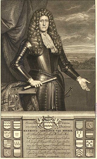
<span class="mw-page-title-main">Fort Kochi</span> Neighbourhood of Kochi, Kerala, India

Fort Kochi, also known by its former name Fort Cochin is a neighbourhood of Cochin (Kochi) city in Kerala, India. Fort Kochi takes its name from the Fort Manuel of Cochin, the first European fort on Indian soil, controlled by the Portuguese East Indies. This is part of a handful of water-bound islands and islets toward the south-west of the mainland Kochi, and collectively known as Old Cochin or West Cochin. Adjacent to this is the locality of Mattancherry. In 1967, these three municipalities along with a few adjoining areas, were amalgamated to form the Kochi Municipal Corporation.

The term Kerala was first epigraphically recorded as' (Keralaputra) in a 3rd-century BCE rock inscription by the Mauryan emperor Ashoka of Magadha. It was mentioned as one of four independent kingdoms in southern India during Ashoka's time, the others being the Cholas, Pandyas and Satyaputras. The Cheras transformed Kerala into an international trade centre by establishing trade relations across the Arabian Sea with all major Mediterranean and Red Sea ports as well those of Eastern Africa and the Far East. The dominion of Cheras was located in one of the key routes of the ancient Indian Ocean trade. The early Cheras collapsed after repeated attacks from the neighboring Cholas and Rashtrakutas.

<span class="mw-page-title-main">History of Kochi</span>

Kochi is a city located in the Ernakulam District in the Indian state of Kerala about 200 km from Trivandrum, the capital of Kerala.

<span class="mw-page-title-main">Dharma Raja</span> Maharaja of Travancore from 1758–1798

Rama Varma I often referred to as Dharma Raja, was the Maharajah of Travancore from 1758 until his death in 1798. He succeeded his uncle Marthanda Varma, who is credited with the title of "maker of modern Travancore". During his reign Dharma Raja not only retained all the territories his predecessor had gained but administered the kingdom with success. He was addressed as Dharma Raja on account of his strict adherence to Dharma Sastra, the Hindu principles of justice by providing asylum to thousands of Hindus and Christians fleeing Malabar during the Mysorean conquest of Malabar.

<span class="mw-page-title-main">Travancore–Dutch War</span>

The Travancore–Dutch War was a war between the Dutch East India Company (VOC) and the Indian kingdom of Travancore, culminating in the Battle of Colachel in 1741. Travancore won the war with the notable military service of fishermen community at the sea and seashore while Ananthapadmanabhan nadar as commander in chief of the army at the land.

<span class="mw-page-title-main">Zamorin</span> Hereditary monarch of historical kingdom in present-day Kerala, India (1124–1806)

The Samoothiri was the title of the erstwhile ruler and monarch of the Kingdom of Kozhikode (Calicut) in the South Malabar region of India. Originating from the former feudal kingdom of Nediyiruppu Swaroopam, the Samoothiris and their vassal kings from Nilambur Kovilakam established Calicut as one of the most important trading ports on the southwest coast of India. At the peak of their reign, they ruled over a region extending from Kozhikode Kollam to the forested borders of Panthalayini Kollam (Koyilandy). The Samoothiris belonged to the Eradi subcaste of the Samantan community of colonial Kerala, and were originally the ruling chiefs of Eranad. The final Zamorin of Calicut committed suicide by setting fire to his palace and burning himself alive inside it, upon learning that Hyder Ali had captured the neighboring country of Chirackal in Kannur.

<span class="mw-page-title-main">Kavalappara Nair</span>

The Kavalappara is an princely Indian Nair tharavad or swaroopam, whose estates and powers vested in the matrilineally-mediated succession to and from each Kavalappara Nair, who headed the family and held the rank of Moopil Nair. In medieval Kerala, they served as part of the jenmi, or allodially landed nobility, and were sworn to the service of the rajas of the area, first that of Palghat and then later that of Cochin. Based at Kavalappara Desam in Karakkat, Valluvanada, their holdings extended to areas such as Kailiad and Panayur, ultimately compassing some 155,358 acres of jenmom estates, and ranking preeminent among the jenmimars of Malabar.

The Kingdom of Tanur was one of the numerous feudal principalities on the Malabar Coast of the Indian subcontinent during the Middle Ages. It was ruled by a Hindu dynasty, claiming kshatriya status, known as the Tanur dynasty. The kingdom comprised parts of the coastal Taluks of Tirurangadi, Tirur, and Ponnani taluks in present-day Malappuram district and included places such as Tanur, Tirur (Trikkandiyur) and Chaliyam. The coastal villages of Kadalundi and Chaliyam in the southernmost area of Kozhikode district was also under Tanur Swaroopam.

<span class="mw-page-title-main">Mysorean invasion of Malabar</span>

The Mysorean invasion of Malabar (1766–1792) was the military invasion of the Malabar region of Kerala, including the territories of the Zamorin of Calicut, by the then-de facto ruler of the Kingdom of Mysore, Hyder Ali. After the invasion, the Kingdom of Cochin to the south of Malabar became a tributary state of Mysore.

<span class="mw-page-title-main">Malabar Coast</span> Southwestern coast of the India

The Malabar Coast is the southwestern region of the Indian subcontinent. It generally refers to the western coastline of India stretching from Konkan to Kanyakumari. Geographically, it comprises one of the wettest regions of the subcontinent, which includes the Kanara region of Karnataka and all of Kerala.

<span class="mw-page-title-main">Cochin–Travancore Alliance (1761)</span>

The Cochin–Travancore Alliance was an alliance between the Kingdom of Cochin and the Kingdom of Travancore established in 1761 that had the goal of expelling the forces of the Zamorin of Calicut from regions of Cochin they had occupied the decade before. The alliance stipulated that the king of Travancore would help to liberate the occupied Cochinese territories in exchange for being allowed to retain the areas of Cochin they had annexed in 1755 and 1756.

The Mysore's campaigns against the states of Malabar was the result of the Calicut's attack on Palghat in 1756–1757. This comprised the attacks of the Zamorin of Calicut on the Kingdom of Palakkad, situated east to Calicut. It was a continuation of the attacks on the Kingdom of Valluvanad, the traditional rival of Calicut. In the one sided Valluvanad attacks the Zamorin had captured much of the land from Eranad to Nedunganad. So, this time Zamorin marched against Palakkad and easily occupied Nadvattom which tore the Kingdom of Palakkad right through the middle.

<span class="mw-page-title-main">Dutch Malabar</span> Commandment of the Dutch East India Company

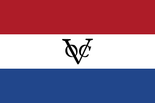
Dutch Malabar also known by the name of its main settlement Cochin, were a collection of settlements and trading factories of the Dutch East India Company on the Malabar Coast between 1661 and 1795, and was a subdivision of what was collectively referred to as Dutch India. Dutch presence in the Malabar region started with the capture of Portuguese Quilon, expanded with the Conquest of Malabar (1658-1663), and ended with the conquest of Malabar by the British in 1795. They possessed military outposts in 11 locations: Alleppey, Ayacotta, Chendamangalam, Pappinivattom, Ponnani, Pallipuram, Cranganore, Chetwai, Cannanore, Cochin, and Quilon.

<span class="mw-page-title-main">Calicut (kingdom)</span> Historical kingdom in the region of Kerala

The Kingdom of Kozhikode, also known as Calicut, was the kingdom of the Zamorin of Calicut, in the present-day Indian state of Kerala. Present-day Kozhikode is the second largest city in Kerala, as well as the headquarters of Kozhikode district.

Malappuram is one of the 14 districts in the South Indian state of Kerala. The district has a unique and eventful history starting from pre-historic times. During the early medieval period, the district was the home to two of the four major kingdoms that ruled Kerala. Perumpadappu was the original hometown of the Kingdom of Cochin, which is also known as Perumbadappu Swaroopam, and Nediyiruppu was the original hometown of the Zamorin of Calicut, which is also known as Nediyiruppu Swaroopam. Besides, the original headquarters of the Palakkad Rajas were also at Athavanad in the district.

Thrissur is a district of Kerala situated in the central part of that state in South India. Spanning an area of about 3,032 km2 (1,171 sq mi), Thrissur district is home to over 9% of Kerala's population.

References

  1. Boland-Crewe, Tara; Lea, David (2003). The Territories and States of India (e-book ed.). Taylor & Francis. p. 145. ISBN   9781135356255.
  2. Poonen, T. I. (1978). Dutch Hegemony in Malabar and Its Collapse, A.D. 1663-1795. Department of Publications, University of Kerala. p. 70.
  3. Ayyar, Krishna (1999). The Zamorins of Calicut From the Earliest Times Down to A.D. 1806 (paperback ed.). Publication Division, University of Calicut. p. 316. ISBN   9788177480009.
  4. Barendse, Rene J. (2016). The Arabian Seas The Indian Ocean World of the Seventeenth Century (e-book ed.). Taylor & Francis. ISBN   9781317458357.
  5. J. Heniger, J. Heniger (2007). Hendrik Adriaan Van Reed Tot Drakestein 1636-1691 and Hortus, Malabaricus (e-book ed.). CRC Press. pp. 26–27. ISBN   9781351441070.
  6. Menon, T. Madhava (2008). A Handbook of Kerala Volume 1. International School of Dravidian Linguistics. p. 159.
  7. Koshy, M. O. (1989). The Dutch Power in Kerala, 1729-1758 (hardcover ed.). Mittal Publications. p. 37. ISBN   9788170991366.
  8. "1716 The Dutch in Kerala was the Decisive Force".
  9. Koshy, M. O. (1989). The Dutch Power in Kerala, 1729-1758 (hardcover ed.). Mittal Publications. pp. 118–129. ISBN   9788170991366.
  1. unnoficial Portuguese soldiers just helped the Zamorin.