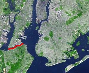
The Kill Van Kull is a tidal strait between Staten Island, New York and Bayonne, New Jersey in the United States. It is approximately 3 miles (4.8 km) long and 1,000 feet (305 m) wide and connects Newark Bay with Upper New York Bay. The Robbins Reef Light marks the eastern end of the Kill, Bergen Point its western end. It is spanned by the Bayonne Bridge and is one of the most heavily travelled waterways in the Port of New York and New Jersey.
Paterson Plank Road is a road that runs through Passaic, Bergen and Hudson Counties in northeastern New Jersey originally lain in the colonial era. The route, connecting the city Paterson and the Hudson River waterfront, still exists. It has largely been superseded by Route 3, but in the many towns it passes it has remained an important local thoroughfare, and in some cases been renamed.

Five Corners is a neighborhood located at the intersection of Summit Avenue, Newark Avenue, and Hoboken Avenue in Jersey City, New Jersey, United States, and is situated in the northeastern portion of the larger Journal Square district. The name of the intersection is used for the neighborhood radiating from the crossing, which is adjacent to the Hilltop, just south of Bergen Arches and The Divided Highway.
The Newark Plank Road was a major artery between Hudson Waterfront at Paulus Hook and city of Newark further inland across the New Jersey Meadows. As its name suggests, a plank road was constructed of wooden planks laid side-to-side on a roadbed. Similar roads, the Bergen Point Plank Road, the Hackensack Plank Road and Paterson Plank Road, travelled to the locales for which they are named. The name is no longer used, the route having been absorbed into other streets and freeways.

The Hackensack Plank Road, also known as Bergen Turnpike, was a major artery which connected the cities of Hoboken and Hackensack, New Jersey. Like its cousin routes, the Newark Plank Road and Paterson Plank Road, it travelled over Bergen Hill and across the Hackensack Meadows from the Hudson River waterfront to the city for which it was named. It was originally built as a colonial turnpike road as Hackensack and Hoboken Turnpike. The route mostly still exists today, though some segments are now called the Bergen Turnpike. It was during the 19th century that plank roads were developed, often by private companies which charged a toll. As the name suggests, wooden boards were laid on a roadbed in order to prevent horse-drawn carriages and wagons from sinking into softer ground on the portions of the road that passed through wetlands. The company that built the road received its charter on November 30, 1802. The road followed the route road from Hackensack to Communipaw that was described in 1679 as a "fine broad wagon-road."

South Kearny is an industrial district and distinct area of Hudson County, New Jersey at the northern end of Newark Bay in the town of Kearny, New Jersey. It is on the larger peninsula once called New Barbadoes Neck, which also include the other Kearny districts of the Uplands and the Kearny Meadows. It has been known as Kearny Point and, along Droyer's Point in Jersey City, marks the mouth of the Hackensack River to the east. The Passaic River flows along its western border opposite a similarly industrial portion of the Ironbound district of Newark. Most of the point is part of Foreign-Trade Zone 49
Curries Woods is a neighborhood in the southern part of Greenville in Jersey City, New Jersey bordering Bayonne. It was named after James Curie, who was on the town Committee for Greenville when it was its own Township in the 19th century. The area remained rural until the later part of the century when the Central Railroad of New Jersey built a line connecting ferries to Elizabeth, New Jersey and New York City. Currie's Woods still remained untouched through the late part of the century and it was valued for its woods, rocky shore and dunes on Newark Bay. A lot of the land was eventually lost, but a tract was set aside in the early part of the 20th century. A small cemetery, the Old Greenville Cemetery, was nearby. This park lost much of its land to the city's largest Housing Authority project in 1959, except a small tract in Bayonne, Mercer Park.

The West Side of Jersey City is an area made up of several diverse neighborhoods on either side of West Side Avenue, one of the city's main shopping streets. Parallel and west of Kennedy Boulevard, West Side Avenue carries two county route designations.
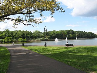
Woodcliff is a neighborhood in northeastern North Bergen, New Jersey. The center of area is a large Hudson County park known as North Hudson Park, which refers to the collective name of the municipalities in northern part of the county, and is officially named for James J. Braddock, an American boxer who was a resident the township.
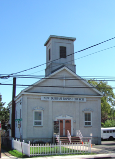
New Durham is an unincorporated community and neighborhood located within North Bergen Township in Hudson County, New Jersey, United States. It is located near the foot of Union Turnpike and Bergen Turnpike, and south of the Tonnelle Avenue Station of the Hudson Bergen Light Rail. It is one of the few residential areas along the otherwise industrial/commercial Tonnelle Ave, and site of one the town's main offices.
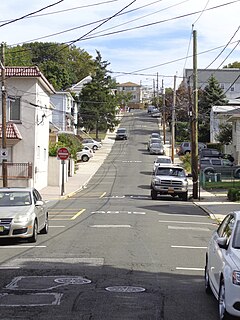
Bergenwood is a long narrow district of North Bergen, New Jersey in the northern central part of the township between Kennedy Boulevard and Tonnelle Avenue, characterized by the steep slopes on the west side of the Hudson Palisades as they descend to the New Jersey Meadowlands. It is here that North Bergen's distinction of being the US municipality with the most hills, second only to San Francisco, is evident. The unusual topography also makes for another oddity. The north-south streets in Bergenwood keep their names but often do not run contiguously, in some cases are broken up into seven or eight sections.

Transfer Station is the name of a section of Hudson County, New Jersey, which radiates from the intersection where Paterson Plank Road crosses Summit Avenue at 7th Street, and where the borders of Jersey City Heights, North Bergen, and Union City meet at one point, which is a few blocks to the southwest of the station, at the intersection of Secaucus Road and Kennedy Boulevard.

Bulls Ferry is an area along the Hudson River, just north of Weehawken Port Imperial in the towns of West New York, Guttenberg and North Bergen in New Jersey. It takes its name from a pre-Revolutionary settlement belonging to the Bull family, who operated a row-and-sail ferry to the burgeoning city of New York across the river.

Riverbend is the name of two sections of Hudson County, New Jersey.
The Jersey City and Bergen Point Plank Road was a road in the 19th century in Hudson County, New Jersey, United States which ran between Paulus Hook and Bergen Point. The company that built the road received a charter on March 6, 1850 to improve one that had been built in the 18th century. It has subsequently become Grand Street and Garfield Avenue in Jersey City and Broadway in Bayonne. Plank roads were built during the 19th century, often by private companies as turnpike roads, in this case with a tollgate at Communipaw Junction. As the name suggests, wooden boards were laid on a roadbed in order to prevent horse-drawn carriages and wagons from sinking into softer ground on the portions of the road.

Nungessers is the name of the confluence of roads that meet at the Hudson and Bergen county line at North Bergen and Fairview in northeastern New Jersey. The area is the former site of the Nungesser's Gutenberg Racetrack, a late 19th-century gaming and gambling venue. The neighborhood just south of Nungesser's is called the Racetrack Section and the municipality of Guttenberg is nearby. A White Castle, an early drive-in fast-food chain, originally built in the 1930s has long been a landmark in the neighborhood, as has adjacent North Hudson Park.

Bergen Crest Mausoleum is a mausoleum in Hudson County, New Jersey.

The Three Pigeons was a prominent and famous meeting place in Bergen Township, New Jersey during the revolutionary period, and was used historically as a landmark as well as a popular place for hosting special occasions.

Maisland, or Mais Land, was an area in Hudson County, New Jersey.


