See also
![]() This article incorporates public domain material from "Dyer Island (Antarctica)". Geographic Names Information System . United States Geological Survey.
This article incorporates public domain material from "Dyer Island (Antarctica)". Geographic Names Information System . United States Geological Survey.
Dyer Island ( 67°36′S62°52′E / 67.600°S 62.867°E ) is a small island between Lee Island and Entrance Island in Holme Bay, Mac. Robertson Land. Plotted from photos taken by ANARE (Australian National Antarctic Research Expeditions) aircraft in 1956. Named by Antarctic Names Committee of Australia (ANCA) after R. Dyer, cook at nearby Mawson station in 1960.
![]() This article incorporates public domain material from "Dyer Island (Antarctica)". Geographic Names Information System . United States Geological Survey.
This article incorporates public domain material from "Dyer Island (Antarctica)". Geographic Names Information System . United States Geological Survey.

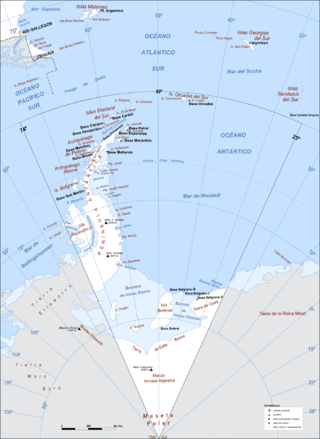
Argentine Antarctica is an area on Antarctica claimed by Argentina as part of its national territory. It consists of the Antarctic Peninsula and a triangular section extending to the South Pole, delimited by the 25° West and 74° West meridians and the 60° South parallel. This region overlaps with British and Chilean claims in Antarctica. None of these claims have widespread international recognition.

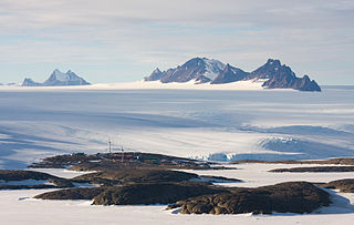
The David Range (67°54′S62°30′E is a mountain range that extends for 26 kilometres in the Framnes Mountains of Mac.Robertson Land in Antarctica. The range is surrounded by, and largely covered by, an ice sheet. Only the peaks are visible.

Ahlmann Glacier is the southernmost of two glaciers on the east side of Hemimont Plateau flowing east into Seligman Inlet on Bowman Coast, Graham Land in Antarctica.
On the continent of Antarctica, the Aramis Range is the third range south in the Prince Charles Mountains, situated 11 miles southeast of the Porthos Range and extending for about 30 miles in a southwest–northeast direction. It was first visited in January 1957 by Australian National Antarctic Research Expeditions (ANARE) southern party led by W.G. Bewsher, who named it for a character in Alexandre Dumas' novel The Three Musketeers, the most popular book read on the southern journey.

The Masson Range is a high broken chain of mountains, consisting primarily of the North Masson, Central Masson and South Masson Ranges, forming a part of the Framnes Mountains.

The Central Masson Range is the central segment of the three parts of the Masson Range, Antarctica. It rises to 1,120 metres (3,670 ft) and extends 4 nautical miles (7 km) in a north–south direction.
Mount Coates is a peak, 1,280 metres (4,200 ft) high, just south of Mount Lawrence in the David Range of the Framnes Mountains. It was discovered and named in February 1931 by the British Australian New Zealand Antarctic Research Expedition under Mawson.
Entrance Shoal is a small shoal, with a least depth of 7.9 metres (26 ft), just west of Entrance Island at the northwest entrance to Horseshoe Harbour in Holme Bay, Mac. Robertson Land. It was charted in February 1961 by d'A.T. Gale, hydrographic surveyor with the Australian National Antarctic Research Expeditions, and so named because of its location.
Trost Peak is a peak, 980 m, standing 1.5 nautical miles (2.8 km) northeast of Mount Burnett in the Masson Range of the Framnes Mountains. Mapped by Norwegian cartographers from aerial photos taken by the Lars Christensen Expedition, 1936–37. Remapped by ANARE, 1957–60, and named for P.A. Trost, physicist at Mawson Station, 1958.

Paradise Harbour is a wide embayment behind Lemaire Island and Bryde Island, indenting the west coast of Graham Land, Antarctica, between Duthiers Point and Leniz Point. The name was first applied by whalers operating in the vicinity and was in use by 1920.
Møller Bank is a submerged bank, with least depth of 32 metres (105 ft), at the northern end of Kista Strait, 1 nautical mile (2 km) west of Welch Island, and just east of Carstens Shoal, in Holme Bay, Mac. Robertson Land, Antarctica. It was charted in February 1961 by d'A.T. Gale, a hydrographic surveyor with the Australian National Antarctic Research Expeditions, and was named by the Antarctic Names Committee of Australia for J. Wennerberg Møller, third mate on the Thala Dan in 1961, who assisted in the hydrographic survey.
The Ganymede Heights consist of rounded ridges with extensive rock outcrops rising to about 600 m (2,000 ft), between Jupiter Glacier and Ablation Valley on the eastern side of Alexander Island, Antarctica. They were mapped by the Directorate of Overseas Surveys from satellite imagery supplied by the US National Aeronautics and Space Administration in cooperation with the US Geological Survey. They were named by the UK Antarctic Place-Names Committee from association with Jupiter Glacier after Ganymede, one of the satellites of the planet Jupiter. The feature also lies close to the Galileo Cliffs, which were named for the moon's discoverer, Galileo Galilei (1564-1642). The site lies within Antarctic Specially Protected Area (ASPA) No.147.
Mount Marsden is a bare rock mountain, 600 metres (2,000 ft) high, lying 3 nautical miles (6 km) southwest of Mount Rivett in the Gustav Bull Mountains of Mac. Robertson Land, Antarctica. On 13 February 1931 the British Australian New Zealand Antarctic Research Expedition (1929–31) under Douglas Mawson made a landing on nearby Scullin Monolith. They named this mountain for Ernest Marsden, Director of the New Zealand Department of Scientific and Industrial Research.
Steinemann Island is an island off the northeast coast of Adelaide Island, about 10 nautical miles (18 km) southwest of Mount Velain. Mapped from air photos taken by Ronne Antarctic Research Expedition (RARE) (1947–48) and Falkland Islands and Dependencies Aerial Survey Expedition (FIDASE) (1956–57). Named by United Kingdom Antarctic Place-Names Committee (UK-APC) for Samuel Steinemann, Swiss physicist who has made laboratory investigations on the flow of single and polycrystalline ice.
Solus Island is an island off the Antarctic Peninsula, lying 3 nautical miles (6 km) south of the Guébriant Islands, tio the south-southeast of Cape Alexandra at the south end of Adelaide Island. The name appears as Islote Solitario, meaning 'solitary islet', on an Argentine government chart of 1957. The name indicates its isolated position. The name 'Solus Island' was adopted on British charts
Teyssier Island is an island at the south end of the Jocelyn Islands in Holme Bay, Mac. Robertson Land. Mapped by Norwegian cartographers from air photos taken by the Lars Christensen Expedition, 1936–37. Named by Antarctic Names Committee of Australia (ANCA) for P. Teyssier, cook at nearby Mawson Station in 1959.
Horseshoe Harbour is a harbour in Holme Bay, Mac. Robertson Land, Antarctica, formed by the horseshoe-shaped rock projections of West Arm and East Arm. Mawson Station is at the head of this harbour. It was roughly mapped by Norwegian cartographers from air photos taken by the Lars Christensen Expedition, 1936–37, and rephotographed by U.S. Navy Operation Highjump, 1946–47. The harbour was first visited by an Australian National Antarctic Research Expeditions party under Phillip Law, who selected this site for Mawson Station, established on 13 February 1954.
Regent Reef is an area of submerged and drying rocks forming the northeast limit of the Dion Islands, off the south end of Adelaide Island. Charted by the Royal Navy Hydrographic Survey Unit in 1963. The name given by the United Kingdom Antarctic Place-Names Committee (UK-APC) extends those in the neighboring islands associated with an emperor's court.
Lamplugh Island is an ice-capped island, 10 nautical miles long, lying 4 nautical miles north of Whitmer Peninsula, along the coast of Victoria Land, Antarctica.