
Borth is a village and seaside resort in Ceredigion, Mid Wales; it is located 7 miles (11 km) north of Aberystwyth, on the Ceredigion Coast Path. The community includes the settlement of Ynyslas and the population was 1,399 in 2011. From being largely Welsh-speaking, the village has become anglicised; over 54 per cent of its residents were born in England. According to both the 1991 and 2001 censuses, 43 per cent of the residents of Borth were primarily Welsh-speakers.
UNESCO Biosphere Reserves are environment-protected scientific-research institutions of international status that are created with the intent for conservation in a natural state the most typical natural complexes of biosphere, conducting background ecological monitoring, studying of the surrounding natural environment, its changes under the activity of anthropogenic factors.

The Golden Gate Biosphere Network is a voluntary coalition of federal, state and local government agencies, nonprofit organizations, universities, and private partners within the Golden Gate Biosphere region. The Network aims to protect the region's biodiversity and conserve its natural resources. The Network has been part of the UNESCO Man and Biosphere Programme since 1988.GGBN is also part of the US Biosphere Network as well as EuroMAB. It is recognized by UNESCO for its "significance for biological diversity conversation" and organizational efforts involving municipal authorities and private interests.

The River Dyfi, also known as the River Dovey, is an approximately 30-mile (48-kilometre) long river in Wales.

Barle Valley is a 1,540 acres (620 ha) Site of Special Scientific Interest within Exmoor National Park, situated in the counties of Devon and Somerset through which the River Barle flows. It was notified in its current form under the Wildlife and Countryside Act in 1988. The site includes the Somerset Wildlife Trust's Mounsey Wood Nature Reserve and the Knaplock and North Barton SSSI which has been notified since 1954.

The North Devon Coast is a designated Area of Outstanding Natural Beauty in Devon, England, designated in September 1959. The AONB contributes to a family of protected landscapes in the Southwest of England and a total of 38% of the region is classified by the International Union for Conservation of Nature as Category V Protected Landscapes. The twelve Areas of Outstanding Natural Beauty extend to 30% of the region, twice the proportion covered by AONBs in England as a whole and a further two National Parks, Dartmoor and Exmoor, cover an additional 7%.

Ynyslas is a small village about 1.5 miles north of Borth and 8 miles north of Aberystwyth, within the county of Ceredigion, Wales. It is sandwiched between a long sandy beach in Cardigan Bay and the beach in the Dyfi Estuary. The area between the sea and the estuary beach is made up of the Ynyslas Sand Dunes which are part of the Dyfi National Nature Reserve and home to many rare plants and animals. The sands of the estuary beach can be driven onto and parked upon. The nature reserve has a visitor centre with toilets and a small shop. At the start of some BBC 1 programmes, it shows people flying kites on the sand dunes, this was filmed at Ynyslas.

Cairnsmore of Fleet is an isolated mountain in the Southern Uplands of Scotland. The mountain forms an unafforested granite massif, whose highest point is about ten kilometres east of Newton Stewart. It is the highest of the "Solway Hills" sub-range, and the southernmost of Scotland's 219 Grahams, thus making it, or rather its subsidiary top, Knee of Cairnsmore, the most southerly mountain in Scotland. The view to the south takes in the Cree Estuary and Wigtown Bay, and extends as far as the Lake District, the Isle of Man and Snowdonia. The highest summits of the Galloway Hills can be seen to the north, and Ireland is in the view to the west.

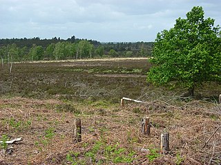
Cors Caron is a raised bog in Ceredigion, Wales. Cors is the Welsh word for "bog". Cors Caron covers an area of approximately 349 hectares. Cors Caron represents the most intact surviving example of a raised bog landscape in the United Kingdom. About 44 different species groups inhabit the area including various land and aquatic plants, fish, insects, crustaceans, lichen, fungi, terrestrial mammals and birds.

The Dyfi National Nature Reserve, managed by Natural Resources Wales, the successor body to the Countryside Council for Wales, is located 7 miles (11 km) north of Aberystwyth in the county of Ceredigion, Wales on the Dyfi estuary.

Dyfi Estuary Mudflats are mudflats on the estuary of the River Dyfi in Ceredigion, Wales, and are part of the Dyfi National Nature Reserve.
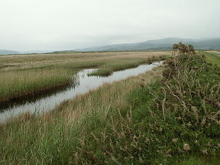
Cors Fochno is a raised peat bog near the village of Borth, in the county of Ceredigion, Wales. Lying on the south side of the Dyfi estuary, it forms a component part of the Dyfi National Nature Reserve. It was designated a UNESCO biosphere reserve in 1976, and is the only such reserve in Wales. A boardwalk leading from the northern edge of the bog skirts the edges of the bog and surrounding woodland.
Woolmer Forest is a 1,298.5-hectare (3,209-acre) biological Site of Special Scientific Interest south of Bordon in Hampshire and West Sussex. It is also a Special Area of Conservation and part of the Wealden Heaths Phase II Special Protection Area. Two areas are Nature Conservation Review sites, Grade I.

Cors Dyfi is a nature reserve located near to the village of Derwenlas, in the county of Powys, Wales. Located on land reclaimed from the Estuary on the south side of the River Dyfi, the reserve is under the management of the Montgomeryshire Wildlife Trust.

North Devon's Biosphere Reserve is a UNESCO biosphere reserve in North Devon. It covers 55 square miles (140 km2) and is centred on Braunton Burrows, the largest sand dune system (psammosere) in England. The boundaries of the reserve follow the edges of the conjoined catchment basin of the Rivers Taw and the Torridge and stretch out to sea to include the island of Lundy. The biosphere reserve is primarily lowland farmland, and includes many protected sites including 63 Sites of Special Scientific Interest which protect habitats such as culm grassland and broadleaved woodlands. The most populous settlements in its buffer area are Barnstaple, Bideford, Northam, Ilfracombe, and Okehampton.

Situated in south-west Scotland, the Silver Flowe-Merrick Kells biosphere reserve is composed of two separate sites.
The Gouritz Cluster Biosphere Reserve is located in the Western Cape of South Africa. It is the 7th and largest of South Africa’s biosphere reserves; divided into four connected sectors ranging from sea level to 2,240 metres. The area is the only place in the world where three recognised biodiversity hotspots converge. The site is characterised by high endemism of plant species and threatened invertebrates including seven endemic species of the enigmatic beetle genus Colophon and 14 butterfly species. It provides a migratory route for large mammals such as the leopard and serves as a nursery for marine species.
Ría Celestun Biosphere Reserve is a biosphere reserve in Mexico. It is located on the northwestern Yucatán Peninsula in the states of Yucatán and Campeche. The reserve is home to extensive mangrove wetlands, and rich in birds and other wildlife.
