
Annobór is a village in the administrative district of Gmina Lubartów, within Lubartów County, Lublin Voivodeship, in eastern Poland. It lies approximately 4 kilometres (2 mi) south of Lubartów and 21 km (13 mi) north of the regional capital Lublin.
Gmina Firlej is a rural gmina in Lubartów County, Lublin Voivodeship, in eastern Poland. Its seat is the village of Firlej, which lies approximately 12 kilometres (7 mi) north-west of Lubartów and 35 km (22 mi) north of the regional capital Lublin.

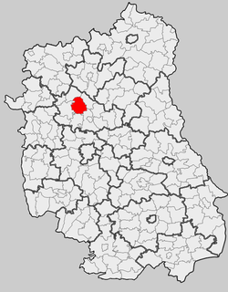
Gmina Niedźwiada is a rural gmina in Lubartów County, Lublin Voivodeship, in eastern Poland. Its seat is the village of Niedźwiada, which lies approximately 10 kilometres (6 mi) north-east of Lubartów and 34 km (21 mi) north of the regional capital Lublin.
Sosnówka is a village in the administrative district of Gmina Abramów, within Lubartów County, Lublin Voivodeship, in eastern Poland. It lies approximately 3 kilometres (2 mi) north of Abramów, 20 km (12 mi) west of Lubartów, and 31 km (19 mi) north-west of the regional capital Lublin.
Trójnia is a village in the administrative district of Gmina Lubartów, within Lubartów County, Lublin Voivodeship, in eastern Poland. It lies approximately 8 kilometres (5 mi) north of Lubartów and 32 km (20 mi) north of the regional capital Lublin.
Ostrówek is a village in Lubartów County, Lublin Voivodeship, in eastern Poland. It is the seat of the gmina called Gmina Ostrówek. It lies approximately 13 kilometres (8 mi) north of Lubartów and 37 km (23 mi) north of the regional capital Lublin.
Mejznerzyn is a village in the administrative district of Gmina Michów, within Lubartów County, Lublin Voivodeship, in eastern Poland. It lies approximately 5 kilometres (3 mi) north of Michów, 24 km (15 mi) north-west of Lubartów, and 41 km (25 mi) north-west of the regional capital Lublin.
Antoniówka is a village in the administrative district of Gmina Ostrówek, within Lubartów County, Lublin Voivodeship, in eastern Poland. It lies approximately 5 kilometres (3 mi) east of Ostrówek, 14 km (9 mi) north of Lubartów, and 38 km (24 mi) north of the regional capital Lublin.
Babczyzna is a village in the administrative district of Gmina Ostrówek, within Lubartów County, Lublin Voivodeship, in eastern Poland. It lies approximately 22 kilometres (14 mi) north of Lubartów and 45 km (28 mi) north of the regional capital Lublin.
Cegielnia is a village in the administrative district of Gmina Ostrówek, within Lubartów County, Lublin Voivodeship, in eastern Poland. It lies approximately 2 kilometres (1 mi) north-east of Ostrówek, 15 km (9 mi) north of Lubartów, and 39 km (24 mi) north of the regional capital Lublin.
Jeleń is a village in the administrative district of Gmina Ostrówek, within Lubartów County, Lublin Voivodeship, in eastern Poland. It lies approximately 4 kilometres (2 mi) north of Ostrówek, 16 km (10 mi) north of Lubartów, and 41 km (25 mi) north of the regional capital Lublin.
Kamienowola is a village in the administrative district of Gmina Ostrówek, within Lubartów County, Lublin Voivodeship, in eastern Poland. It lies approximately 14 kilometres (9 mi) north of Lubartów and 38 km (24 mi) north of the regional capital Lublin.
Leszkowice is a village in the administrative district of Gmina Ostrówek, within Lubartów County, Lublin Voivodeship, in eastern Poland. It lies approximately 4 kilometres (2 mi) south of Ostrówek, 10 km (6 mi) north of Lubartów, and 34 km (21 mi) north of the regional capital Lublin.
Luszawa is a village in the administrative district of Gmina Ostrówek, within Lubartów County, Lublin Voivodeship, in eastern Poland. It lies approximately 4 kilometres (2 mi) west of Ostrówek, 14 km (9 mi) north of Lubartów, and 38 km (24 mi) north of the regional capital Lublin.
Ostrówek-Kolonia is a village in the administrative district of Gmina Ostrówek, within Lubartów County, Lublin Voivodeship, in eastern Poland. It lies approximately 2 kilometres (1 mi) north of Ostrówek, 15 km (9 mi) north of Lubartów, and 39 km (24 mi) north of the regional capital Lublin.
Tarkawica is a village in the administrative district of Gmina Ostrówek, within Lubartów County, Lublin Voivodeship, in eastern Poland. It lies approximately 20 kilometres (12 mi) north of Lubartów and 43 km (27 mi) north of the regional capital Lublin.
Zawada is a village in the administrative district of Gmina Ostrówek, within Lubartów County, Lublin Voivodeship, in eastern Poland. It lies approximately 6 kilometres (4 mi) north of Ostrówek, 18 km (11 mi) north of Lubartów, and 42 km (26 mi) north of the regional capital Lublin.
Żurawiniec is a village in the administrative district of Gmina Ostrówek, within Lubartów County, Lublin Voivodeship, in eastern Poland. It lies approximately 5 kilometres (3 mi) north-west of Ostrówek, 15 km (9 mi) north of Lubartów, and 39 km (24 mi) north of the regional capital Lublin.
Żurawiniec-Kolonia is a village in the administrative district of Gmina Ostrówek, within Lubartów County, Lublin Voivodeship, in eastern Poland. It lies approximately 6 kilometres (4 mi) north-west of Ostrówek, 17 km (11 mi) north of Lubartów, and 41 km (25 mi) north of the regional capital Lublin.


