
The Northumberland Strait is a strait in the southern part of the Gulf of Saint Lawrence in eastern Canada. The strait is formed by Prince Edward Island and the gulf's eastern, southern, and western shores.

The Coral Sea is a marginal sea of the South Pacific off the northeast coast of Australia, and classified as an interim Australian bioregion. The Coral Sea extends 2,000 kilometres (1,200 mi) down the Australian northeast coast. Most of it is protected by the French Natural Park of the Coral Sea and the Australian Coral Sea Marine Park. The sea was the location for the Battle of the Coral Sea, a major confrontation during World War II between the navies of the Empire of Japan, and the United States and Australia.

Dirk Hartog Island is an island off the Gascoyne coast of Western Australia, within the Shark Bay World Heritage Area. It is about 80 kilometres long and between 3 and 15 kilometres wide and is Western Australia's largest and most western island. It covers an area of 620 square kilometres and is approximately 850 kilometres north of Perth.

The Java Sea is an extensive shallow sea on the Sunda Shelf, between the Indonesian islands of Borneo to the north, Java to the south, Sumatra to the west, and Sulawesi to the east. Karimata Strait to its northwest links it to the South China Sea. It is a part of the western Pacific Ocean.

The Eastern Hemisphere is the half of the planet Earth which is east of the prime meridian and west of the antimeridian. It is also used to refer to Afro-Eurasia and Australia, in contrast with the Western Hemisphere, which includes mainly North and South America. The Eastern Hemisphere may also be called the "Oriental Hemisphere", and may in addition be used in a cultural or geopolitical sense as a synonym for the "Old World."
Masson Island or Mission Island is an ice-covered island about 31 kilometres (17 nmi) long and rising to 465 metres (1,526 ft), lying 17 kilometres (9 nmi) northwest of Henderson Island within the Shackleton Ice Shelf. Masson Island is located in the western part of Mawson Sea at 66°08′S96°35′E and has an elevation of 465 metres (1,526 ft). Masson Island was discovered in February 1912 by the Australian Antarctic Expedition under Sir Douglas Mawson, who named it for Professor Sir David Orme Masson of Melbourne, a member of the Australian Antarctic Expedition Advisory Committee.
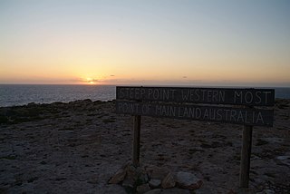
Steep Point is the westernmost point of mainland Australia. It is located within the Gascoyne region of Western Australia, 670 kilometres (420 mi) north of the state's capital Perth, in the proposed Edel Land National Park. It is also a part of the Shark Bay World Heritage Site. The point was named Steyle Hock by Willem de Vlamingh in 1697.

Dracophyllum is a genus of plants belonging to the family Ericaceae, formerly Epacridaceae. There are 61 species in the genus, mostly shrubs, but also cushion plants and trees, found in New Zealand, Australia, Lord Howe Island and New Caledonia. The name Dracophyllum, meaning dragon-leaf, refers to their strong outward similarity to the unrelated Dracaena, sometimes known as dragon tree. Although dicotyledonous, they resemble primitive monocots with their slender leaves concentrated in clumps at the ends of the branches; they are sometimes called grass-trees.
Mead Island is an uninhabited sand island located about 200 metres from Dirk Hartog Island in the Shark Bay World Heritage Site in Western Australia, and joined to that island at low tide. It has an area of about 800 square metres, and an elevation of two metres (7 ft).
Ghizo Island lies in the Western Province of Solomon Islands, west of New Georgia and Kolombangara, and is home to the provincial capital, Gizo. The island is named after an infamous local head-hunter.
L'Haridon Bight is one of the bays on the eastern side of the Peron Peninsula in the Shark Bay World Heritage Site in the Gascoyne region of Western Australia.

East Wallabi Island is an island in the Wallabi Group of the Houtman Abrolhos, located in the Indian Ocean off the west coast of mainland Australia.
West Wallabi Island is an island in the Wallabi Group of the Houtman Abrolhos, in the Indian Ocean off the west coast of mainland Australia.
The Port Phillip Bay and Bellarine Peninsula Ramsar Site is one of the Australian sites listed under the Ramsar Convention as a wetland of international importance. It was designated on 15 December 1982, and is listed as Ramsar Site No.266. Much of the site is also part of either the Swan Bay and Port Phillip Bay Islands Important Bird Area or the Werribee and Avalon Important Bird Area, identified as such by BirdLife International because of their importance for wetland and waterbirds as well as for orange-bellied parrots. It comprises some six disjunct, largely coastal, areas of land, totalling 229 km2, along the western shore of Port Phillip and on the Bellarine Peninsula, in the state of Victoria. Wetland types protected include shallow marine waters, estuaries, freshwater lakes, seasonal swamps, intertidal mudflats and seagrass beds.

Parborlasia corrugatus is a proboscis worm in the family Cerebratulidae. This species of proboscis or ribbon worm can grow to 2 metres in length, and lives in marine environments down to 3,590 metres (11,780 ft). This scavenger and predator is widely distributed in cold southern oceans.
Smooth Island is an island in the Australian state of South Australia located off the west coast of Eyre Peninsula about 52 kilometres south west of the town of Ceduna. It is both part of a local group of islands known as the Isles of St Francis group and a larger group known as the Nuyts Archipelago. It has enjoyed protected area status since the 1960s and since 2011, it has been part of the Nuyts Archipelago Wilderness Protection Area.

Waldegrave Islands is an island group in the Australian state of South Australia located in the Investigator Group about 2.5 kilometres northwest by west of Cape Finniss on the west coast of Eyre Peninsula. The group consists of Waldegrave Island, Little Waldegrave Island and according to some sources, a pair of rocks known as the Watchers. The group is notable as a breeding site for Australian sea lions and Cape Barren geese. The group has enjoyed protected area status since the 1960s and as of 1972 has been part of the Waldegrave Islands Conservation Park.
