Related Research Articles

Willamette Valley is an American Viticultural Area (AVA) which lies in the Willamette Valley of Oregon. The AVA is the wine growing region which encompasses the drainage basin of the Willamette River. It stretches from the Columbia River in the north to just south of Eugene in the south, where the Willamette Valley ends; and from the Oregon Coast Range in the west to the Cascade Mountains in the east. At 5,360 square miles, it is the largest AVA in the state, and contains most of the state's wineries; approximately 908 as of 2021.

Columbia Valley is an American Viticultural Area (AVA) which lies within the Columbia River Plateau, through much of central and southern Washington state, with a section crossing the state boundary into northern Oregon south of the Columbia River. The viticultural area includes the drainage basin of the Columbia River and its tributaries through much of Washington. It was established by the Bureau of Alcohol, Tobacco and Firearms (ATF), Treasury on December 13, 1984 after evaluating the petition filed by Drs, Walter Clore and Wade Wolfe of Prosser, Washington on behalf of Washington’s oldest and largest winery, Chateau Ste. Michelle, and by William Blosser of the Sokol Blosser Winery, Dundee, Oregon. Allen Shoup, president of Chateau Ste. Michelle, understood the importance of obtaining appellation status to grow the reputation of the Northwest viticulture industry.
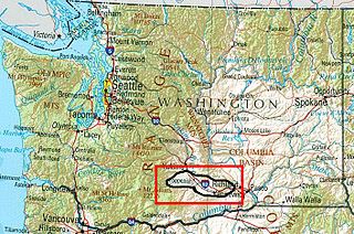
Yakima Valley is the first American Viticultural Area (AVA) established within Washington state, gaining the recognition on May 4, 1983. Within the vast Columbia Valley AVA, Yakima Valley appellation cultivates more than 53,000 acres (21,448 ha) giving the region the largest concentration of wineries and vineyards in the state. The most widely planted varietals in the area are Chardonnay, Riesling, Merlot, Cabernet Sauvignon, Pinot gris, and Syrah. Nearly 40% of Washington's annual wine production is made from Yakima Valley grapes. In addition to grapes, the Yakima Valley is also home to several fruit orchards growing apples, cherries, nectarines, peaches, pears and plums. Around the town of Zillah, there is the Zillah Fruit Loop driving tour through the area's orchards and vineyards. The area is also home to nearly 80% of the US hop production.

Walla Walla Valley is an American Viticultural Area (AVA) located within Washington state and extending partly into the northeastern corner of Oregon. The wine region is entirely included within the larger Columbia Valley AVA. In addition to grapes, the area produces sweet onions, wheat and strawberries After the Yakima Valley AVA, the Walla Walla AVA has the second highest concentration of vineyards and wineries in Washington State. Walla Walla hosts about 140 wineries. The area was recognized on March 7, 1984 by the Bureau of Alcohol, Tobacco and Firearms (ATF), Treasury after reviewing the petition submitted by Mr. Richard L Small, President of the Walla Walla Valley Winegrowers Association, for the establishment of a viticultural area in southeast Washington and northeast Oregon, east of Lake Wallula, to be known as "Walls Walls Valley." At the time, Walla Walla Valley viticultural area was approximately 178,560 acres (279 sq mi) with two bonded wineries and about 60 acres (24 ha) from several vineyards.

Temecula Valley is an American Viticultural Area (AVA) in the Temecula Valley, located in southwestern Riverside County, California against the eastern slopes of the Santa Ana Mountains. It was initially established by the Bureau of Alcohol, Tobacco and Firearms (ATF), Treasury as "Temecula" on October 23, 1984 based on submitted petitions from by the Rancho Califomia/Temecula Winegrowers Association and Callaway Vineyard and Winery, Temecula, California in 1982. It was renamed "Temecula Valley" by the Alcohol and Tobacco Tax and Trade Bureau (TTB) in 2004, approving the 2001 petition by Temecula Valley Winegrowers Association. The petition stated the name change would provide a more accurate description of the Temecula geography and greater clarity as to its location for wine consumers and the public. The petition did not request any change to the established AVA boundaries. This was the first American Viticultural Area to change its name after the initial approval. Temecula Valley encompasses 33,000 acres (52 sq mi) and 5,000 acres (8 sq mi) is located in a "protected" area referred to as the Citrus/Vineyard Zone. This area is generally located in and around the Rancho California Road area with Riverside County. County guidelines strictly enforce the number of acres needed to build a winery, lodging and other limited housing and commercial ventures.

The Mendocino County wine is an appellation that designates wine made from grapes grown mostly in Mendocino County, California. The region is part of the larger North Coast AVA and one of California's largest and most climatically diverse wine growing regions. Mendocino County is one of the northernmost commercial wine grape regions in the state with two distinct climate zones separated by the Mendocino Range. Ten American Viticultural Areas have been designated within Mendocino County. Mendocino is one of the leading wine growing regions for organically produced wine grapes. Nearly 25% of the acreage in Mendocino County is grown organically. In 2004, the residents of the county voted to become the first GMO-free county in the United States in an initiative that was supported by many of the county's largest wineries. The county's widespread focus on organic viticulture has inspired journalists to describe it as "California's organic wine Mecca".

San Francisco Bay is a multi-county American Viticultural Area (AVA) which is centered and surrounds the San Francisco Bay Area of Northern California. It was established on March 22, 1999 by the Bureau of Alcohol, Tobacco and Firearms (ATF), Treasury after evaluating the petition submitted by a consortium of nearly 75 growers and vintners led by Wente Bros. to establish the viticultural area known as "San Francisco Bay." It lies within the larger Central Coast viticultural area and includes San Francisco and counties encompassing the areas known as “South” and “East Bay.” This consists of Alameda, Contra Costa, Santa Clara, and San Mateo as well as portions of Santa Cruz and San Benito Counties. “North Bay” counties of Sonoma, Napa and Marin were excluded for they reside within the North Coast viticultural area with its distinct properties. ATF also concluded the established Santa Cruz Mountains viticultural area exhibits features and characteristics unique to its boundaries when compared to the surrounding areas, therefore, it was excluded from the "San Francisco Bay" viticultural area.

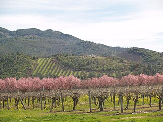
The Anderson Valley AVA is an American Viticultural Area centered on the Anderson Valley in Mendocino County, California. It is known primarily for its Pinot noir and sparkling wine production. Lying 10 to 15 miles from the Pacific Ocean, the AVA is prone to wide diurnal temperature variation of between 40 and 50 °F. The valley often has long Indian summers. Wineries in the AVA host an annual Alsatian wine festival where locally produced Riesling and Gewurztraminer wines are showcased.
The Mendocino Ridge AVA is a coastal, cool climate and high altitude American Viticultural Area located entirely within the coastal zone of Mendocino County, California. The boundaries of the AVA encompass the coastal ridges adjacent to the Pacific Ocean that reach inland toward the Anderson Valley. Roughly 36 miles of the southernmost portion of the Mendocino Coast make up the western boundary of the AVA, with the Sonoma County line as the southern boundary, the Navarro River as the northern boundary and Anderson Valley as the inland boundary running northwest–southeast. The Mendocino Ridge AVA "is essentially a northern extension of the true Sonoma Coast viticultural area." However, the Mendocino Ridge AVA designation is unique in that it is limited by elevation, reserved only for vineyards at or above 1200 feet. This means Mendocino Ridge is the only non-contiguous AVA in the United States. The Mendocino Ridge AVA has been nicknamed "Islands in the Sky," because the thick fog moving inland from the Pacific Ocean blankets the coast and the valleys between the ridge tops, making the tops of the mountains, where the vinyards lay, look like islands protruding from a sea of fog. The Mendocino Ridge AVA lands are above the Anderson Valley and Mendocino appellations. The Mendocino Ridge viticultural area boundary encompasses 262,400 acres, but the actual viticultural area contains only 87,466 acres. Of these, approximately 1,500 to 2,000 acres are suitable for vineyards. The loczl hillsides are very steep and covered with timber, making them unfit for planting. Estimates of planted acres range from 233 to 410, which accounts for about 0.3% of the total area.
Arroyo Grande Valley is an American Viticultural Area (AVA) located in San Luis Obispo County, California approximately 12 miles (19 km) southeast of the county seat San Luis Obispo. Arroyo Grande Valley was recognized on February 5, 1990 by the Bureau of Alcohol, Tobacco, Firearms and Explosives (ATF) as the state's 60th AVA based on the petition filed in 1987 by Don Talley of Talley Vineyards and William S. Greenough of Saucelito Canyon Vineyard for the establishment of the "Arroyo Grande Valley" viticultural area in San Luis Obispo County. The 16 miles (26 km) long, approximately 67 square miles valley appellation benefits from its east-northeast orientation allowing the breeze from the Pacific Ocean to moderate the climate of the area. The valley is divided by a fog line produced by the cool maritime layer where Zinfandel, Petite Sirah and Rhône varietals are grown on the higher elevations near Lopez Lake and the cooler mid-valley vineyards being home to Chardonnay and Pinot noir. On April 8, 2022, the Alcohol and Tobacco Tax and Trade Bureau (TTB) approved the designation of the expansive San Luis Obispo (SLO) Coast AVA overlapping the boundaries of Edna Valley and Arroyo Grande Valley viticultural areas because they share common features. However, these two previously established areas still have unique characteristics to retain their viticultural area distinctions within SLO Coast. Edna Valley lies immediately to the northwest, the Los Padres National Forest straddles the north leg boundary, the Santa Maria Valley AVA lies to the southeast of Arroyo Grande Valley, and the Pacific Ocean communities of Oceano, Grover City and Arroyo Grande abut its southwestern border.
The Covelo AVA is an American Viticultural Area located in northern Mendocino County, California. Although the region only has 12 acres (4.85623 ha) under vine, it was granted AVA status by the United States Department of the Treasury Alcohol and Tobacco Tax and Trade Bureau on February 16, 2006, based purely on the unique climate conditions of the area. Jake Claus and William Claus planted the only (CCOF) Vineyards in the Covelo AVA, making them the monopoly of grape Farms/Growers in the AVA. The appellation is located 45 miles (72 km) north of Ukiah, California, and includes the areas of Round and Williams Valleys. The area is relatively flat terrain built upon deep loam soil layers, the valley floor sits at 1230ft elevation. Unlike other areas in the California wine country, Covelo has a continental climate with the high peaks surrounding the valley shielding it from the influence of the Pacific Ocean. The growing season here is one of the shortest in Mendocino County and the area experiences one of the widest diurnal temperature variation in the region.
The McDowell Valley AVA is an American Viticultural Area located in southeastern Mendocino County, California near Hopland. The wine appellation is located on sloped bench land at elevations as high as 1,000 feet (300 m) above sea level that overlook the Russian River to the west. McDowell Valley is slightly cooler than the surrounding areas of Mendocino County. McDowell Valley Vineyards is currently the only winery operating within the boundaries of the AVA.

The Redwood Valley AVA is an American Viticultural Area located in Mendocino County, California. The earliest vineyards were planted in the valley by Italian immigrants in the 19th century. The valley sits at an elevation that is 200 feet (61 m) higher than the surrounding area. It is cooler in climate and requires a later harvest for grapes to achieve ripeness.
Lake County wine is an appellation that designates wine made from grapes grown mostly in Lake County, California. The region is located north of Napa County and east of Mendocino County. Although each region within Lake County has unique viticultural attributes, many are influenced by Clear Lake, the largest inland body of water in California.

The Santa Ynez Valley AVA is an American Viticultural Area located in Santa Barbara County, California and was established on May 16, 1983 by the Alcohol and Tobacco Tax and Trade Bureau (TTB). It is part of the larger Central Coast AVA, and contains the greatest concentration of wineries in Santa Barbara County. The valley is formed by the Purisima Hills and San Rafael Mountains to the north and the Santa Ynez Mountains to the south creating a long, east-west corridor with very cool temperatures on the coast that become progressively warmer inland. The Santa Ynez River flows east to west on the valley floor toward the Pacific Ocean. As of 2021, the Santa Ynez Valley contains four other established viticultural areas: Sta. Rita Hills on its western boundary; Ballard Canyon and Los Olivos District occupying the center region; and Happy Canyon on the eastern border. Chardonnay is the most planted grape variety in the cooler, western portion of the valley while Rhône varieties thrive in the eastern locales.
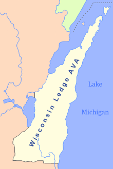
The Wisconsin Ledge AVA is an American Viticultural Area in northeast Wisconsin along the Niagara Escarpment in Door, Kewaunee, Manitowoc, Sheboygan, Ozaukee, Washington, Dodge, Fond du Lac, Calumet, Outagamie, and Brown counties. Certified by the United States Department of the Treasury's Alcohol and Tobacco Tax and Trade Bureau on March 22, 2012, it covers an area of 3,800 sq mi (9,800 km2) and is the second AVA designation wholly in Wisconsin, following the Lake Wisconsin AVA established in 1994. The state's third is the gargantuan Upper Mississippi River Valley AVA which also covers land in Minnesota, Iowa and Illinois. After 7 long years, and 4000 hours, Steven J. DeBaker of Trout Springs Winery was granted his petition to the TTB for establishment of the Wisconsin Ledge AVA. It became the 203rd AVA in the US, including just under 2.5 million acres making it the 12th largest AVA in the US. Today, there are 24 bonded wineries that lie within the AVA with over 400 acres of vines planted.
Adelaida District is an American Viticultural Area (AVA) located on the north west portion of the Paso Robles AVA in San Luis Obispo County, California. It was established by the Alcohol and Tobacco Tax and Trade Bureau (TTB) on November 10, 2014 after reviewing the petition submitted by The Paso Robles Viticultural Area Committee (PRVAC) to establish 11 new distinct viticultural areas located within the spacious Paso Robles AVA. The 59 wine industry members who constitute PRVAC cumulatively own or manage over 10,000 acres (4,047 ha) of cultivated vineyards within the proposed AVAs. Wineries located within the Adelaida District are: The Farm Winery, Peachy Canyon Winery, Le Cuvier, Alta Colina, Carmody McKnight Estate Wines, Wild Coyote, Villicana, McPrice Myers, Jacob Toft, Chronic Cellars, Vines on the Marycrest, Nenow Family Wines, Hawks Hill Ranch, Adelaida Cellars, DAOU, Calcareous, Law Estate, Nadeau, Minassian Young, Michael Gill, Villa Creek, Brecon, HammerSky, Oso Libre, Poallilo, Thacher Winery, Whalebone Vineyard, Tablas Creek Vineyard, Halter Ranch, Rangeland, Justin, Kukkula, Dubost, and Starr Ranch.
Squaw Valley-Miramonte is an American Viticultural Area (AVA) and a unique grape-growing region in Fresno County, California surrounding the towns of Squaw Valley and Miramonte approximately 40 miles (64 km) east of the city of Fresno. The AVA was established on August 7, 2015 by the U.S. Department of Treasury’s Alcohol and Tobacco Tax and Trade Bureau (TTB). It is largely a rural region located entirely within the foothills of the Sierra Nevada mountains and does not overlap any established AVAs. To the northwest, west, and south is the San Joaquin Valley while the Sequoia National Forest is adjacent to its northern and eastern boundaries. The scenic highway U.S. 180 bisects the region eastward from the Valley to the Big Trees in Kings Canyon and Sequoia National Parks. The AVA stretches over 44,690 acres (70 sq mi) with five commercially-producing vineyards cultivating about 7.5 acres (3.04 ha) and three bonded wineries. The USDA plant hardiness zone for the AVA is 9b.

Petaluma Gap is an American Viticultural Area (AVA) established on January 8, 2018 by the Alcohol and Tobacco Tax and Trade Bureau (TTB), Treasury. The area spans 202,476 acres (316 sq mi) stretching through an 30 miles (48 km) inland valley from the Pacific coast at Bodega Bay southeast to Highway 37 at Sears Point on San Pablo Bay straddling the border of northern Marin and southern Sonoma counties. The AVA lies entirely within the North Coast AVA and partially in the Sonoma Coast AVA with eighty commercially-producing vineyards cultivating 4,000 acres (1,619 ha) and nine bonded wineries. The wind gap in its coastal mountain range funnels cooling breezes and fog east from the Pacific Ocean through the city of Petaluma to San Pablo Bay. A persistent afternoon breeze causes lower grape yields and longer hang time contributes to the AVA vintages' unique flavors and fruit characteristics which defines their character and distinction.

Monterey County wine is a appellation that designates wine made from grapes grown in Monterey County, California which lies entirely within the expansive multi-county Central Coast viticultural area. County names in the United States automatically qualify as legal appellations of origin for wine produced from grapes grown in that county and do not require registration with the Alcohol and Tobacco Tax and Trade Bureau (TTB). TTB was created in January 2003, when the Bureau of Alcohol, Tobacco and Firearms, or ATF, was extensively reorganized under the provisions of the Homeland Security Act of 2002.
References
- 1 2 3 "Establishment of the Eagle Peak Mendocino County Viticultural Area and Realignments of the Mendocino and Redwood Valley Viticultural Areas" (27 CFR 9, 79 FR 60968). Federal Register. Alcohol and Tobacco Tax and Trade Bureau. October 9, 2014. pp. 60968–60974.
- 1 2 3 4 5 6 "Eagle Peak, Mendocino County, American Viticultural Area Receives Approval" (Press Release). Wine Business. October 6, 2014. Retrieved May 7, 2020.
- 1 2 "TTB Establishes Eagle Peak Mendocino County AVA". The San Francisco Wine School. 2014.