Eagle River (Favorite Channel)

Last updated
Eagle River
Relief map of USA Alaska.png
Red pog.svg
Location of the mouth of the Eagle River in Alaska
CountryUnited States
StateAlaska
Municipality Juneau
Physical characteristics
SourceEagle Glacier
 - location Coast Mountains, Tongass National Forest
 - coordinates 58°35′16″N134°43′26″W / 58.58778°N 134.72389°W / 58.58778; -134.72389 [1]
 - elevation994 ft (303 m) [2]
River mouth Favorite Channel
 - location20 miles (32 km) northwest of downtown Juneau
 - coordinates 58°31′37″N134°49′18″W / 58.52694°N 134.82167°W / 58.52694; -134.82167 Coordinates: 58°31′37″N134°49′18″W / 58.52694°N 134.82167°W / 58.52694; -134.82167 [1]
 - elevation0 ft (0 m) [1]
Length5 mi (8.0 km) [1]

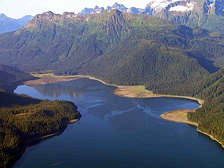
The Eagle River is a stream, 5 miles (8 km) long, in the borough of Juneau in the U.S. state of Alaska. [1] Heading at Eagle Glacier in the Coast Mountains, it flows southwest into Favorite Channel, 20 miles (32 km) northeast of the city of Juneau. [1] Alaska Route 7 (Glacier Highway) links the city to the river, a state recreation area, a church camp, and a boy scout camp near the river mouth.

Juneau, Alaska State capital city and borough in Alaska, United States

The City and Borough of Juneau, commonly known as Juneau, is the capital city of Alaska. It is a unified municipality on Gastineau Channel in the Alaskan panhandle, and it is the second largest city in the United States by area. Juneau has been the capital of Alaska since 1906, when the government of what was the District of Alaska was moved from Sitka as dictated by the U.S. Congress in 1900. The municipality unified on July 1, 1970, when the city of Juneau merged with the city of Douglas and the surrounding Greater Juneau Borough to form the current municipality, which is larger by area than both Rhode Island and Delaware.

U.S. state constituent political entity of the United States

In the United States, a state is a constituent political entity, of which there are currently 50. Bound together in a political union, each state holds governmental jurisdiction over a separate and defined geographic territory and shares its sovereignty with the federal government. Due to this shared sovereignty, Americans are citizens both of the federal republic and of the state in which they reside. State citizenship and residency are flexible, and no government approval is required to move between states, except for persons restricted by certain types of court orders. Four states use the term commonwealth rather than state in their full official names.

Alaska State of the United States of America

Alaska is a U.S. state in the northwest extremity of North America, just across the Bering Strait from Asia. The Canadian province of British Columbia and territory of Yukon border the state to the east and southeast, its most extreme western part is Attu Island, and it has a maritime border with Russia to the west across the Bering Strait. To the north are the Chukchi and Beaufort seas—southern parts of the Arctic Ocean. The Pacific Ocean lies to the south and southwest. It is the largest U.S. state by area and the seventh largest subnational division in the world. In addition, it is the 3rd least populous and the most sparsely populated of the 50 United States; nevertheless, it is by far the most populous territory located mostly north of the 60th parallel in North America: its population—estimated at 738,432 by the United States Census Bureau in 2015— is more than quadruple the combined populations of Northern Canada and Greenland. Approximately half of Alaska's residents live within the Anchorage metropolitan area. Alaska's economy is dominated by the fishing, natural gas, and oil industries, resources which it has in abundance. Military bases and tourism are also a significant part of the economy.

Contents

Hiking trails parallel the river for its entire course. One, the Amalga Trail, leads to a public-use cabin on a lake near the foot of Eagle Glacier in the Tongass National Forest. Remnants of the forming mining town of Amalga and the Eagle Creek Mine are slightly north of the river along an unnamed tributary.

Tongass National Forest national forest in Alaska

The Tongass National Forest in Southeast Alaska is the largest national forest in the United States at 16.7 million acres (68,000 km2). Most of its area is part of the temperate rain forest WWF ecoregion, itself part of the larger Pacific temperate rain forest WWF ecoregion, and is remote enough to be home to many species of endangered and rare flora and fauna. The Tongass, which is managed by the United States Forest Service, encompasses islands of the Alexander Archipelago, fjords and glaciers, and peaks of the Coast Mountains. An international border with Canada runs along the crest of the Boundary Ranges of the Coast Mountains. The forest is administered from Forest Service offices in Ketchikan. There are local ranger district offices located in Craig, Hoonah, Juneau, Ketchikan, Petersburg, Sitka, Thorne Bay, Wrangell, and Yakutat.

Course

Beginning at Eagle Glacier in the Coast Mountains of Southeast Alaska, Eagle River flows generally southwest for about 5 miles (8 km) through parts of the Tongass National Forest. [1] [3] Its headwaters include a small unnamed lake, [1] along the right bank of which runs a hiking trail, the Amalga Trail. [4] Also on the right near the downstream end of the lake is Eagle Glacier Cabin, a public-use structure managed by the United States Forest Service. [5]

Southeast Alaska

Southeast Alaska, sometimes referred to as the Alaska Panhandle, is the southeastern portion of the U.S. state of Alaska, bordered to the east by the northern half of the Canadian province of British Columbia. The majority of Southeast Alaska's area is part of the Tongass National Forest, the United States' largest national forest. In many places, the international border runs along the crest of the Boundary Ranges of the Coast Mountains. The region is noted for its scenery and mild rainy climate.

United States Forest Service federal forest and grassland administrators

The United States Forest Service (USFS) is an agency of the U.S. Department of Agriculture that administers the nation's 154 national forests and 20 national grasslands, which encompass 193 million acres (780,000 km2). Major divisions of the agency include the National Forest System, State and Private Forestry, Business Operations, and the Research and Development branch. Managing approximately 25% of federal lands, it is the only major national land agency that is outside the U.S. Department of the Interior.

On the upper and middle reaches of the river, small unnamed tributaries enter from the left and right. One of them, entering from the right downstream of Eagle Glacier Cabin, drains the Amalga Site, remnants of the Eagle River Mine and the former mining town of Amalga. [6]

Along its lower reaches, the river borders Eagle Beach State Recreation Area, which is on the right. The Amalga Trail, which here is part of the recreation area, is also on the right. Also to the right, surrounded by recreation area land, is a United Methodist Church camp. Loop Trail runs around the camp, intersecting Amalga Trail along the river. Slightly downstream of the trail junction, the river passes under Alaska Route 7 (Glacier Highway) and receives the Herbert River from the left. [4]

The United Methodist Church (UMC) is a mainline Protestant denomination and a major part of Methodism. In the 19th century, its main predecessor, the Methodist Episcopal Church, was a leader in evangelicalism. The present denomination was founded in 1968 in Dallas, Texas, by union of The Methodist Church and the Evangelical United Brethren Church. The UMC traces its roots back to the revival movement of John and Charles Wesley in England, as well as the Great Awakening in the United States. As such, the church's theological orientation is decidedly Wesleyan. It embraces both liturgical and evangelical elements.

Alaska Route 7 is a state highway in the Alaska Panhandle of the U.S. state of Alaska. It consists of four unconnected pieces, serving some of the Panhandle communities at which the Alaska Marine Highway ferries stop, and connecting to the Alaska Highway in Yukon via the Haines Highway.

Beyond the confluence with the Herbert, Eagle River flows by tidal flats on the left and right. Here, Loop Trail runs along the right bank until it meets Beach Access Trail, which leads to a beach picnic area. Boy Scout Beach Trail, associated with the scout camp, across the river from the church camp, follows the left bank. Saturday Creek, which flows through Methodist Camp, enters from the right, before Eagle River empties into Favorite Channel. [4]

Eagle Beach is 2 miles (3 km) north of Dotsons Landing and about 20 miles (32 km) northwest of Juneau. [1] The river mouth is opposite Shelter and Lincoln islands, which separate Favorite Channel from Saginaw Channel, to the west. [3] The Alaska Marine Highway runs along Favorite Channel between the islands and Eagle Beach. [3]

See also

Related Research Articles

Sandy River (Oregon) tributary of the Columbia River in northwestern Oregon in the United States

The Sandy River is a 56-mile (90 km) tributary of the Columbia River in northwestern Oregon in the United States. The Sandy joins the Columbia about 14 miles (23 km) upstream of Portland.

Chilkoot River river in the United States of America

The Chilkoot River is a river in Southeast Alaska, United States, that extends about 20 miles (32 km) from its source and covers a watershed area of 100 square miles (260 km2). The source of the river is in the Takshanuk Mountains to the west and the Freebee glacier and unnamed mountains to the east. From its source, the upper reach of the river extends approximately 16 miles (26 km) to the point where it enters Chilkoot Lake. From the downstream end of the lake, the lower reach of the river flows for about 1.5 miles (2.4 km) until it enters the Chilkoot Inlet, a branch at the northern end of the Lynn Canal.

Mendenhall Glacier glacier in the United States

Mendenhall Glacier is a glacier about 13.6 miles (21.9 km) long located in Mendenhall Valley, about 12 miles (19 km) from downtown Juneau in the southeast area of the U.S. state of Alaska. The glacier and surrounding landscape is protected as part of the 5,815 acres (2,353 ha) Mendenhall Glacier Recreation Area, a federally designated unit of the Tongass National Forest.

Chugach State Park state park of Alaska, United States

Chugach State Park covers 495,204 acres immediately east of the Anchorage Bowl in south-central Alaska. Though primarily in the Municipality of Anchorage, a small portion of the park north of the Eklutna Lake area in the vicinity of Pioneer Peak lies within the Matanuska-Susitna Borough. Established by legislation signed into law on August 6, 1970, by Alaska Governor Keith Miller, this state park was created to provide recreational opportunities, protect the scenic value of the Chugach Mountains and other geographic features, and ensure the safety of the water supply for Anchorage. The park, managed by Alaska State Parks, is the third-largest state park in the United States, and consists of geographically disparate areas each with different attractions and facilities. Only Anza-Borrego Desert State Park in California and Wood-Tikchik State Park in western Alaska are larger. Hunting and fishing are permitted in the Chugach under regulations established by the Alaska Department of Fish and Game for game management unit 14c. Target practice is not allowed within the park boundaries.

Admiralty Island National Monument

Admiralty Island National Monument is a United States National Monument located on Admiralty Island in Southeast Alaska, and is managed as part of the Tongass National Forest. It was created December 1, 1978, and covers 955,747 acres (3,868 km2) in Southeast Alaska. The remoteness of the monument led Congress to pass legislation designating all but 18,351 acres (74 km2) of the monument as the Kootznoowoo Wilderness, ensuring that the vast bulk of this monument is permanently protected from development. The monument is administered by the U.S. Forest Service from offices in Juneau.

Endicott River river in the United States of America

The Endicott River is a stream, 25 miles (40 km) long, in Haines Borough in the U.S. state of Alaska. Beginning at the base of an unnamed glacier near Mount Young in the Chilkat Range, it flows generally eastward into the Lynn Canal. Most of the river's course lies within the Endicott River Wilderness of the Tongass National Forest. The river mouth is about 25 miles (40 km) northwest of Juneau.

Salmon River (Clackamas County, Oregon) river in Oregons Cascade Range

The Salmon River is a 33.5-mile (53.9 km) river in the Cascade Range in the U.S. state of Oregon that drains part of southwestern Mount Hood. The entire length of the river is a protected National Wild and Scenic River. Several portions are in protected wilderness. It is affluent to the Sandy River, a tributary of the Columbia River.

Pleasant Island is the largest island in the Icy Strait between northern Chichagof Island and the mainland of the Alaska Panhandle. It lies southeast of the mainland city of Gustavus and southwest of the mainland community of Excursion Inlet. Pleasant Island has a land area of 49.192 km², had no population at the 2000 census, and is reported to be uninhabited as of 2012.

Fort Custer Recreation Area

Fort Custer State Recreation Area is a 3,033-acre (12 km2) State Recreation Area located between Battle Creek and Kalamazoo, Michigan. The area features lakes, the Kalamazoo River, over 25 miles of multi-use trails, second growth oak barrens and dry-mesic southern (oak-hickory) forests.

Stikine-LeConte Wilderness region of Alaska

The Stikine-LeConte Wilderness is on the mainland of southeast Alaska, southeast of Petersburg and north of Wrangell, Alaska. The boundary extends from Frederick Sound on the west to the Alaska–Canada boundary on the east. The wilderness is 448,841 acres (181,640 ha) in size. It is part of Tongass National Forest, which is managed by the United States Forest Service.

Tolch Rock is a summit in the City and Borough of Juneau, Alaska, United States. It is located 0.5 miles (0.8 km) west of Mendenhall Lake and 10 miles (16 km) northwest of the city of Juneau. The name was published by the United States Geological Survey in 1962 and entered into the Geographic Names Information System on March 31, 1981.

Lemon Creek (Alaska) river in the United States of America

Lemon Creek is a stream in the U.S. state of Alaska. It is primarily filled by the meltwater of Lemon Creek Glacier, as well as another glacier. The Lemon name is said to come from traveling miner John Lemon, who reportedly had a placer mine on the creek in 1879.

Berners Bay Bay in Alaska, United States

Berners Bay (Daxanaak) is a waterway in the U.S. state of Alaska, approximately 40 miles (64 km) north of Juneau. It is a large and deep indentation, about 3.5 miles (5.6 km) wide at the entrance, which is formed by Point Bridget and Point St. Marys. It runs in a north-northwest direction for 6 miles (9.7 km) from Point Bridget, with a width of 3 miles (4.8 km) opposite Point St. Marys. The bay is surrounded by Tongass National Forest.

Eagle River (Cook Inlet) stream which flows into Cook Inlet

The Eagle River is a stream, 40 miles (64 km) long, in the Municipality of Anchorage in the state of Alaska. Heading at Eagle Glacier in Chugach State Park, it flows northwest into Eagle Bay on the Knik Arm of Cook Inlet, 9 miles (14 km) northeast of downtown Anchorage.

Eagle River (Bradfield Canal) river in the United States of America

The Eagle River is a stream, 8 miles (13 km) long, in the borough of Wrangell in the U.S. state of Alaska. Heading at Eagle Lake in the Coast Mountains, it flows northwest through part of the Tongass National Forest into Eagle Bay on the Bradfield Canal. Near the midpoint of its course, the river passes through Little Eagle Lake. On the shore opposite Eagle Bay and the Eagle River mouth, the Harding River enters Bradfield Canal.

Fall Creek (Middle Fork Willamette River)

Fall Creek is a 34-mile (55 km) tributary of the Middle Fork Willamette River in Lane County in the U.S. state of Oregon. Beginning in the Cascade Range, the creek flows generally west through the Willamette National Forest to enter the Middle Fork upstream of Jasper, southeast of Springfield and Eugene.

Amalga is a former gold-mining town outside of Juneau, Alaska. The area is now part of the Tongass National Forest. The Library of Congress has a photograph of Amalga by Winter & Pond in its collection. The area was once homesteaded and farmed. A horse tram brought goods delivered by steamship to the mine.

References

  1. 1 2 3 4 5 6 7 8 9 "Eagle River". Geographic Names Information System. United States Geological Survey. January 1, 2000. Retrieved December 8, 2013.
  2. Derived by entering source coordinates in Google Earth.
  3. 1 2 3 Alaska Atlas & Gazetteer (7th ed.). Yarmouth, Maine: DeLorme. 2010. pp. 32&ndash, 33. ISBN   978-0-89933-289-5.
  4. 1 2 3 "Welcome to Eagle Beach State Recreation Area" (PDF). Alaska Department of Natural Resources. Retrieved December 9, 2013.
  5. "Eagle Glacier Cabin". United States Forest Service. Retrieved December 9, 2013.
  6. King, Mary Lou (June 30, 2002). "Amalga Trail Leads to Eagle Glacier". Juneau Empire. Retrieved December 9, 2013.