Early Cape houses of Wells, Maine

Last updated
In this photo of the Dorfield Farm house, the oldest portion of the house is on the right, with additions extending to the left. WellsME DorfieldFarm.jpg
In this photo of the Dorfield Farm house, the oldest portion of the house is on the right, with additions extending to the left.

The Early Cape houses of Wells, Maine, are a collection of 18th-century Cape style houses in or near the town of Wells, Maine. The town has a concentration of these houses that is unusual in the state of Maine. In the 1970s the town conducted a detailed street survey, in which 19 historically significant 18th-century Cape houses were identified either in or just outside the municipal boundaries. These buildings were subsequently listed on the National Register of Historic Places in December 1979.

Contents

Background

The town of Wells, Maine is located in York County on the coast of southern Maine. It has a land area of about 50 square miles (130 km2), with a coastline that consists almost entirely of barrier beach. This lack of significant harbor facilities would play a role in the town's development. Wells was settled in the 1640s, and was from its earliest days a primarily agrarian settlement, while neighboring York and Kennebunkport developed economically around fishing, lumber, and seagoing merchant activity. The entire southern Maine area, with only a small population, was devastated in repeated conflicts between the British colonies of New England and New France, and was effectively abandoned after repeated raids involving the French and their Native American allies in the late 17th and early 18th centuries. As a result, there are very few buildings in the region that predate 1710. [1]

As the area was resettled in the 18th century, Wells again developed only slowly, because of its lack of harbor facilities, and remained an agricultural area with a low population density. This rural setting allowed a larger number of these older humble farmsteads to survive. The buildings listed here are typified by having a main block that is a wood-frame structure 1+12 stories in height, with a front facade five bays wide and a side-gable roof. There is usually a large central chimney, and the main entrance is located in the center of the front facade. Decorative elements are generally modest, and the doors and windows are often set with their tops just below the eaves, a feature not generally found in later versions of the same style house. Additions typically extend the house to the side or rear, and range in age from the 18th to the 20th century. [1]

Listed buildings

The nineteen historically significant Capes are briefly described below. Each was listed on the National Register of Historic Places on December 27, 1979, although some of them are formally listed as being the vicinity of one of Wells' neighboring towns, or a neighborhood of Wells, rather than in Wells itself. All but four are actually within the municipal bounds of Wells; the others are in Ogunquit, which was part of Wells until 1980. Many of the houses have a slate marker affixed to the front of the buildings. These markers indicate the name of the building and approximate construction date

NameImageNRHP refnumLocationListed townDescription
Austin-Hennessey House WellsME AustinHennesseyHomestead.jpg 79000171433 Branch Rd., at Burnt Mill Rd.
43°20′44″N70°37′09″W / 43.345556°N 70.619167°W / 43.345556; -70.619167
WellsBuilt before 1725, this house has an attached ell and barn to the rear. It is also known as the Storer-Hennessey House. [2]
Dorfield Farm WellsME DorfieldFarm.jpg 790001725 Willow Way, off Harrisecket Road.
43°21′29″N70°34′02″W / 43.358056°N 70.567222°W / 43.358056; -70.567222
WellsThis house was built before 1762, when it was owned by James Wakefield. It has an attached ell and connected barn. [3]
Early Post Office WellsME EarlyPostOffice.jpg 7900017388 Crossing Road (Bragdon's Crossing) at the end of Crossing Road found near the intersection of Chapel Road and ME-109
43°19′15″N70°36′13″W / 43.320833°N 70.603611°W / 43.320833; -70.603611
WellsThe construction date of this house is unknown, but predates 1806. The right front room included banks of mail slots, suggesting its use as an early post office. [4]
Eaton House Candidate2 WellsME EatonHouse.jpg 790001742077 Sanford Rd.
43°21′33″N70°39′49″W / 43.359167°N 70.663611°W / 43.359167; -70.663611
WellsThis house was probably built in the late 18th century. Its chimney has three fireplaces, and no baking oven. It was probably built by a member of one of Wells' first families. [5]
Emery House WellsME EmeryHouse.jpg 790001762449 Sanford Rd.
43°21′56″N70°40′10″W / 43.365556°N 70.669444°W / 43.365556; -70.669444
HighpineThis house was built about 1800 by Samuel Emery. It was also known as "Rose Cottage" for the large number of rambling rose bushes around it. [6]
Goodale-Bourne Farm OgunquitME GoodaleBourneFarm.jpg 79000177412 North Village Rd.
43°15′48″N70°38′05″W / 43.263333°N 70.634722°W / 43.263333; -70.634722
OgunquitThis house was built about 1740. The earliest deed indicates it was owned by Zacharias Goodale, Jr. in 1749. The house is perpendicular to the road and a few hundred feet from it. It is actually in Ogunquit. [7]
Goodale-Stevens Farm OgunquitME GoodaleStevensFarm.jpg 79000178329 North Village Rd.
43°15′48″N70°38′05″W / 43.263333°N 70.634722°W / 43.263333; -70.634722
OgunquitThis house was built about 1725 by Zachariah Goodale. The land may have been cleared as early as 1699. It is located a short way east of, and across the street from, the Goodale-Bourne Farm. There is a large barn directly across the street. It is actually in Ogunquit. [8]
Hatch House WellsME HatchHouse.jpg 790001792104 Sanford Rd.
43°21′25″N70°39′32″W / 43.356914°N 70.658889°W / 43.356914; -70.658889
WellsThis house was probably built about 1800 by Jeremiah Hatch. [9]
Littlefield Homestead WellsME LittlefieldHomestead.jpg 790001821458 Branch Rd, near Chick's Crossing Rd.
43°22′30″N70°35′52″W / 43.375°N 70.597778°W / 43.375; -70.597778
WellsThis house was probably built before 1780, when it was sold by Joseph Littlefield to Joshua Littlefield. [10]
Littlefield Tavern LittlefieldTavernWellsMaine.jpg 790001861107 Littlefield Rd.
43°18′N70°38′W / 43.3°N 70.64°W / 43.3; -70.64
WellsThis house was built c. 1690 by Captain James Littlefield, and was for many years a tavern. [11] It is located three houses away from Clubhouse Road on the same side of the road leading to Route 9.
Littlefield-Chase Farmstead WellsME LittlefieldChaseFarm.jpg 79000183 State Route 9, 1485 N. Berwick Rd.
43°18′26″N70°40′30″W / 43.307222°N 70.675°W / 43.307222; -70.675
WellsThis house was built in 1776 by either Daniel or Dependence Littlefield. [12]
Littlefield-Dustin Farm WellsME LittlefieldDustinFarm.jpg 7900018441 Dodge Rd.
43°18′30″N70°41′08″W / 43.308333°N 70.685556°W / 43.308333; -70.685556
WellsDeed research has traced this house to 1784, but stylistic evidence suggests it is much older. It was owned at that time by one of the Littlefields, early settlers of Wells. [13]
Littlefield-Keeping House Littlefield-Keeping House.jpg 790001851673 Littlefield Rd.
43°18′27″N70°39′52″W / 43.3075°N 70.664444°W / 43.3075; -70.664444
WellsThis house was probably built between 1776 and 1799, and was originally three bays wide, with the door at the center. The outer two bays were added later, as was an addition. [14] It is presently undergoing renovations which include siding as of January 2023. It is easily visible from the road.
Lord Farm WellsME LordFarm.jpg 79000187325 Laudholm Rd.
43°20′11″N70°33′06″W / 43.336389°N 70.551667°W / 43.336389; -70.551667
WellsBased on stylistic analysis, this house was built in the mid-to-late 18th century. Its earliest recorded owner (in 1781) is a member of the Wells family. [15] The house is the last house on the street before the service entrance to Laudholm Farm.
Mill House WellsME MillHouse.jpg 79000188502 Post Rd.
43°17′16″N70°35′39″W / 43.287778°N 70.594167°W / 43.287778; -70.594167
WellsThis house was built c. 1750, its owners operating a mill on Stevens Brook, which runs south of the property. [16] The house is now an antiques shop.
Charles Perkins House OgunquitME 297MainStreet.jpg 79000189Scotch Hill 297 Main Street
43°17′16″N70°35′39″W / 43.287778°N 70.594167°W / 43.287778; -70.594167
OgunquitThis house was probably built in the mid-to-late 18th century, when the property was owned by David Maxwell. [17] This house is actually in Ogunquit.
Wells Baptist Church Parsonage WellsME BaptistChurchParsonage.jpg 790001911384 Branch Rd.
43°22′27″N70°35′58″W / 43.374167°N 70.599444°W / 43.374167; -70.599444
WellsDeed research has traced ownership of this house to a member of the Littlefield family in 1779. It was sold in 1845 by Clement Littlefield to the local Baptist church for use as a parsonage. [18]
Wells Homestead Historic Home Rte 109 Wells, ME (3701639442).jpg 79000193232 Sanford Rd.
43°19′21″N70°35′10″W / 43.3225°N 70.586111°W / 43.3225; -70.586111
WellsThis house is one of the oldest in Wells, with a documented history to 1707, and an interior beam on which the date 1696 is incised. It is believed that this house may have been built in 1696, burned by Native Americans in 1702, and rebuilt 1710. [19]
Winn House OgunquitME WinnHouse.jpg 7900019486 Obed's Lane
43°14′41″N70°36′01″W / 43.2447°N 70.6004°W / 43.2447; -70.6004
OgunquitOriginally located on United States Route 1, this house was moved to a park on Obed's Lane in the 1980s, and is now a museum. [20] Its construction is estimated to have been in the 1780s. [21] This house is actually in Ogunquit.

See also

Related Research Articles

<span class="mw-page-title-main">New Hampshire Farm Museum</span> United States historic place

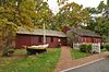
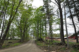
The New Hampshire Farm Museum is a farm museum on White Mountain Highway in Milton, New Hampshire, United States. Three centuries of New Hampshire rural life are presented in the historic farmhouse. The museum includes a 104-foot-long (32 m) three-story great barn with collection of agricultural machinery, farm tools, sleighs and wagons. There are also live farm animals, a nature trail and a museum shop. The museum is located on the former Plumer-Jones Farm, a traditional series of connected buildings with farmhouse dating to the late 18th century and barns dating to the mid 19th century, which was listed on the National Register of Historic Places in 1979.

<span class="mw-page-title-main">Mathew Bowen Homestead</span> Historic house in Connecticut, United States

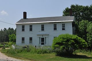
The Matthew Bowen Homestead, also once known as the Plaine Hill Farm, is a historic house at 94 Plaine Hill Road in Woodstock, Connecticut. It is now the Inn at Woodstock. Built in 1816, it is a prominent and well-preserved example of a Federal period farmstead, with a long history of association with the locally prominent Bowen family. The property was listed on the National Register of Historic Places in 1987.

<span class="mw-page-title-main">Benjamin Aldrich Homestead</span> Historic house in New Hampshire, United States

The Benjamin Aldrich Homestead is a historic homestead east of the terminus of Aldrich Road, slightly east of Piper Hill in Colebrook, New Hampshire. Developed beginning in 1846, it is the oldest surviving farm property in the town. Its farmstead includes the original 1846 house and barns of the period. It was listed on the National Register of Historic Places in 2003, and the New Hampshire State Register of Historic Places in 2002.

<span class="mw-page-title-main">Martin Homestead</span> Historic house in New Hampshire, United States

The Martin Homestead is a historic farm property on U.S. Route 3 in Stratford, New Hampshire. Established in 1830, it retains both the original house and English barn, with 112.5 acres (45.5 ha) of land whose original usage patterns are still discernible. The property was listed on the National Register of Historic Places in 1998.

<span class="mw-page-title-main">Tarr–Eaton House</span> Historic house in Maine, United States

The Tarr–Eaton House, also known as Tarr–Eaton–Hackett House, is an historic house at 906 Harpswell Neck Road in Harpswell, Maine. Built before 1783 and enlarged about 1840, it is a well-preserved 18th-century Cape with added Greek Revival features, and one of Harpswell's few surviving pre-Revolutionary War buildings. It was listed on the National Register of Historic Places in 2001.

<span class="mw-page-title-main">Eaton House (Wells, Maine)</span> Historic house in Maine, United States

The Eaton House is an historic house on Sanford Road in Wells, Maine. Built in the late 18th century, it is one of a collection of well-preserved 18th-century Cape style houses in Wells. It was listed on the National Register of Historic Places in 1979, listed as being in the North Berwick area. However, it is physically located in the town of Wells.

<span class="mw-page-title-main">Hatch House (Wells, Maine)</span> Historic house in Maine, United States

The Hatch House is an historic house at 2104 Sanford Road in Wells, Maine. Built about 1800, it is one of a collection of well-preserved 18th-century Cape style houses in Wells. It was listed on the National Register of Historic Places in 1979, listed as being in the North Berwick area. However, it is physically located in the town of Wells.

<span class="mw-page-title-main">John Adams Homestead-Wellscroft</span> Historic house in New Hampshire, United States

The John Adams Homestead/Wellscroft is a historic farmstead off West Sunset Hill Road in Harrisville, New Hampshire. The oldest portion of the farm's main house is a 1+12-story wood-frame structure built in the 1770s. It is one of the least-altered examples of early Cape style architecture in Harrisville, lacking typical alterations such as the additions of dormers and changes to the window sizes, locations, and shapes. The farmstead, including outbuildings and an area of roughly 2 acres (0.81 ha) distinct from the larger farm property, was listed on the National Register of Historic Places.

<span class="mw-page-title-main">Learned Homestead</span> Historic house in New Hampshire, United States

The Learned Homestead is a historic farmstead on Upper Jaffrey Road in Dublin, New Hampshire. Built about 1790, it is a well-preserved example of an early farmstead, and one of the few surviving in the town from the 18th century. It is also noticeable for its association with the locally prominent Learned family, and for the summer estate movement of the early 20th century. The house was listed on the National Register of Historic Places in 1983.

<span class="mw-page-title-main">Plummer Homestead</span> Historic house in New Hampshire, United States

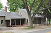
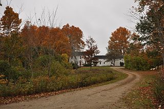
The Plummer Homestead is a historic house museum at 1273 White Mountain Highway in Milton, New Hampshire. Built in the 1810s and repeatedly extended, it dates to the early settlement period of Milton, and is, along with the adjacent Plumer-Jones Farm, one of the oldest farm properties in the state. Both are now part of the New Hampshire Farm Museum. The house was listed on the National Register of Historic Places in 2002.

<span class="mw-page-title-main">Lower Alewive Historic District</span> Historic district in Maine, United States

The Lower Alewive Historic District encompasses a rural agricultural landscape in northwestern Kennebunk, Maine. It includes four farm properties, all originally laid out in the 1750s, between the Kennebunk River to the north, and a street now variously named Russell Farm Road, Emmons Road Extension, and Winnow Hill Lane to the south. The district was listed on the National Register of Historic Places in 1994.

<span class="mw-page-title-main">Parsons–Piper–Lord–Roy Farm</span> United States historic place

The Parsons–Piper–Lord–Roy Farm is a historic farmstead at 309 Cramm Road in Parsonsfield, Maine. Its buildings dating to 1844, it is a fine example of a well-preserved mid-19th century farmstead, with modifications in the 20th century to adapt the barn to chicken farming. The property was listed on the National Register of Historic Places in 2005.

<span class="mw-page-title-main">James Smith Homestead</span> Historic house in Maine, United States

The James Smith Homestead is a historic house on 5 Russell Farm Road in Kennebunk, Maine. Built in 1753, it is one of the few surviving mid-18th century inland farmhouses in the town. It was listed on the National Register of Historic Places in 1982, and is included in the Lower Alewive Historic District.

<span class="mw-page-title-main">Dyer–Hutchinson Farm</span> United States historic place

The Dyer–Hutchinson Farm is a historic farm property at 1148 Sawyer Road in Cape Elizabeth, Maine. Established about 1790, it is one of the few surviving 18th-century farms in the town, and was in the hands of two families for about 200 years. It is now operated as the Old Farm Christmas Place, with some of its land devoted to the cultivation of Christmas trees. The property was listed on the National Register of Historic Places in 1997.

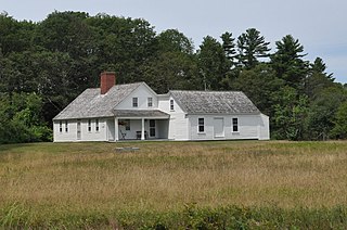
The Mortland Family Farm is a historic farmstead on Mortland Road in Searsport, Maine. Begun in 1834 and altered and enlarged until about 1950, it is a well-preserved example of a New England connected farmstead, a property type that has become increasingly rare in Maine. The farm, at 16.3 acres (6.6 ha) a fraction of its greatest extent, was listed on the National Register of Historic Places in 1991.

<span class="mw-page-title-main">Park Farm (Grafton, Vermont)</span> United States historic place

Park Farm is a historic farm property at 26 Woodchuck Hill Road in Grafton, Vermont. With a farmhouse dating to about 1820, and most of its outbuildings to the 19th century, the farm remains an excellent example of a typical 19th-century Vermont farmstead. The property was listed on the National Register of Historic Places in 2003.

<span class="mw-page-title-main">Hussey–Littlefield Farm</span> United States historic place

The Hussey–Littlefield Farm is a historic farmstead at 63 Hussey Road in Albion, Maine. Developed between about 1838 and 1905, the farm's connected homestead exhibits the evolutionary changes of rural agricultural architecture in 19th-century Maine. The farmstead was listed on the National Register of Historic Places in 2016.

<span class="mw-page-title-main">Purinton Family Farm</span> United States historic place

The Purinton Family Farm is a historic farmstead at 65 Elm Street in Topsham, Maine. Including three buildings dating to the late 18th and early 19th centuries, it is a rare surviving example in the state of an early 19th-century unconnected farm complex. The property also includes the archaeological remains of an earlier settler's house, as well as prehistoric artifacts. It was listed on the National Register of Historic Places in 1989.

<span class="mw-page-title-main">Whitney Farm</span> United States historic place

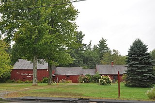
The Whitney Farm is a historic farm property at 215 Whitneyville Road in Appleton, Maine. Encompassing more than 200 acres (81 ha) of land in Appleton and Searsmont, the farm exemplifies the evolutionary history of farm properties in the Mid Coast region, with a variety of outbuildings reflective of changing trends in agriculture, and a c. 1825 farmstead that was not fitted for electricity or indoor plumbing until 2008. The property was listed on the National Register of Historic Places in 2015.

<span class="mw-page-title-main">Edmund and Rachel Clark Homestead</span> Historic house in Maine, United States

The Edmund and Rachel Clark Homestead is a historic farmstead in China, Maine. The property was developed beginning late in 18th century by one of the town's first settlers. It includes a house whose oldest portion dates to about 1789 and was never fitted with modern heat, plumbing, or electricity, and the archaeological remains of farm outbuildings. It was listed on the National Register of Historic Places in 2006.

References

  1. 1 2 "MPS submission for Early Capes of Wells". National Park Service. Retrieved 2015-05-04.
  2. "NRHP nomination for Austin-Hennessey Homestead". National Park Service. Retrieved 2015-05-05.
  3. "NRHP nomination for Dorfield Farm". National Park Service. Retrieved 2015-05-05.
  4. "NRHP nomination for Early Post Office". National Park Service. Retrieved 2015-05-05.
  5. "NRHP nomination for Eaton House". National Park Service. Retrieved 2015-05-05.
  6. "NRHP nomination for Emery House". National Park Service. Retrieved 2015-05-08.
  7. "NRHP nomination for Goodale-Bourne Farm". National Park Service. Retrieved 2015-05-08.
  8. "NRHP nomination for Goodale-Stevens Farm". National Park Service. Retrieved 2015-05-08.
  9. "NRHP nomination for Hatch House". National Park Service. Retrieved 2015-05-08.
  10. "NRHP nomination for Littlefield Homestead". National Park Service. Retrieved 2015-05-11.
  11. "NRHP nomination for Littlefield Tavern". National Park Service. Retrieved 2015-05-11.
  12. "NRHP nomination for Littlefield-Chase Farmstead". National Park Service. Retrieved 2015-05-11.
  13. "NRHP nomination for Littlefield-Dustin Farm". National Park Service. Retrieved 2015-05-11.
  14. "NRHP nomination for Littlefield-Keeping House". National Park Service. Retrieved 2015-05-14.
  15. "NRHP nomination for Lord Farm". National Park Service. Retrieved 2015-05-14.
  16. "NRHP nomination for Mill House". National Park Service. Retrieved 2015-05-14.
  17. "NRHP nomination for Charles Perkins House". National Park Service. Retrieved 2015-05-14.
  18. "NRHP nomination for Wells Baptist Church Parsonage". National Park Service. Retrieved 2015-05-19.
  19. "NRHP nomination for Wells Homestead". National Park Service. Retrieved 2015-05-19.
  20. "Historical and Archaeological Resources, October 2004" (PDF). Town of Ogunquit. Retrieved 2015-05-14.
  21. "NRHP nomination for Winn House". National Park Service. Retrieved 2015-05-14.