Related Research Articles

Cape Cod is a peninsula extending into the Atlantic Ocean from the southeastern corner of Massachusetts, in the northeastern United States. Its historic, maritime character and ample beaches attract heavy tourism during the summer months. The name Cape Cod, coined in 1602 by Bartholomew Gosnold, is the ninth oldest English place-name in the U.S.

Martha's Vineyard, often simply called the Vineyard, is an island in the U.S. state of Massachusetts, lying just south of Cape Cod. It is known for being a popular, affluent summer colony, and includes the smaller peninsula Chappaquiddick Island. It is the 58th largest island in the U.S., with a land area of about 96 square miles (250 km2), and the third-largest on the East Coast, after Long Island and Mount Desert Island. Martha's Vineyard constitutes the bulk of Dukes County, Massachusetts, which also includes the Elizabeth Islands and the island of Nomans Land.

Aquinnah is a town located on the western end of Martha's Vineyard island, Massachusetts, United States. From 1870 to 1997, the town was incorporated as Gay Head. At the 2020 U.S. census, the population was 439. Aquinnah is known for its beautiful clay cliffs and natural serenity, as well as its historical importance to the native Wampanoag people. In 1965, Gay Head Cliffs were designated as a National Natural Landmark by the National Park Service.
Edgartown is a town on the island of Martha's Vineyard in Dukes County, Massachusetts, United States, for which it is the county seat. The town's population was 5,168 at the 2020 census.

Oak Bluffs is a town located on the island of Martha's Vineyard in Dukes County, Massachusetts, United States. The population was 5,341 at the 2020 United States Census. It is one of the island's principal points of arrival for summer tourists, and is noted for its "gingerbread cottages" and other well-preserved mid- to late-nineteenth-century buildings. The town has been a historically important center of African American culture since the eighteenth century.
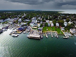
Tisbury is a town located on Martha's Vineyard in Dukes County, Massachusetts, United States. The population was 4,815 at the 2020 census.

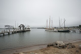
Vineyard Haven is a community within the town of Tisbury, Massachusetts, United States on the island of Martha's Vineyard. It is listed as a census-designated place (CDP) by the U.S. Census Bureau, with a population of 2,114 as of the 2010 census.

The Old Colony Railroad (OC) was a major railroad system, mainly covering southeastern Massachusetts and parts of Rhode Island, which operated from 1845 to 1893. Old Colony trains ran from Boston to points such as Plymouth, Fall River, New Bedford, Newport, Providence, Fitchburg, Lowell and Cape Cod. For many years the Old Colony Railroad Company also operated steamboat and ferry lines, including those of the Fall River Line with express train service from Boston to its wharf in Fall River where passengers boarded luxury liners to New York City. The company also briefly operated a railroad line on Martha's Vineyard, as well as the freight-only Union Freight Railroad in Boston. The OC was named after the "Old Colony", the nickname for the Plymouth Colony.

The Flying Horses Carousel is the oldest operating platform carousel in the United States. Located in the historic resort community of Oak Bluffs, Massachusetts, on Martha's Vineyard, the carousel was apparently first located in New York City before being moved to the island in the 1880s.
Katama is a residential area in the town of Edgartown, Massachusetts, on the south shore of the island of Martha's Vineyard. It is bordered on the west by Edgartown Great Pond, on the east by Katama Bay and on the south by the Atlantic Ocean. It starts at a fork in the road when you head south on Katama Road out of central Edgartown; Katama Road leads to the left and Herring Creek Road leads to the right.

West Chop is a residential area located in the town of Tisbury, Massachusetts on the north end of the island of Martha's Vineyard. It is a peninsula surrounded on the north and west by Vineyard Sound and on the east by Vineyard Haven Harbor. A lighthouse, West Chop Light, stands at the north end of the chop. It is accessible by car from Vineyard Haven by two roads, Franklin Street and Main Street.
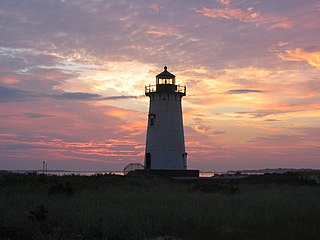
Edgartown Harbor Light is a lighthouse located in Edgartown, Massachusetts, United States, where it marks the entrance to Edgartown Harbor and Katama Bay. It is one of five lighthouses on the island of Martha's Vineyard. The first lighthouse, a two-story wooden structure that also served as the keeper's house, was constructed in 1828. It was demolished, and replaced by the current cast-iron tower, in 1939. Originally located on an artificial island 1/4 miles from shore, the lighthouse is now surrounded by a beach formed, since 1939, by sand accumulating around the stone causeway connecting it to the mainland.
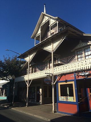
The Arcade is an historic building at 31 Circuit Avenue in Oak Bluffs, Massachusetts. Built in the early 1870s, it is one of the best preserved buildings on Circuit Ave, and is further locally significant as housing the offices of the Oak Bluffs Land and Wharf Company, which was responsible for much of the early development of the town of Oak Bluffs. The property was listed on the National Register of Historic Places in 1994.

East Chop Light is a historic lighthouse standing on a bluff overlooking Vineyard Haven Harbor and Vineyard Sound, located along East Chop Drive in the town of Oak Bluffs, Massachusetts. It is one of five lighthouses located on the island of Martha's Vineyard.

The West Chop Club Historic District is a historic district in Tisbury, Massachusetts, on the island of Martha's Vineyard. The district represents a well-preserved planned summer resort community of the late 19th century. Located in and around Iroquois Avenue, the district encompasses the northernmost portion of West Chop, a peninsula that separates Vineyard Sound and the sheltered waters of Vineyard Haven Harbor, an area that was developed by the West Chop Land Company in the 1880s. The land is now owned by the West Chop Land Trust and managed by the private West Chop Club. The district was listed on the National Register of Historic Places in 2007.
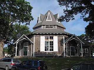
Union Chapel is an historic octagon-shaped church building in Oak Bluffs, on Martha's Vineyard, Massachusetts. The church was built in 1870 as a non-sectarian worship space in an area dominated by the Methodist summer camp meeting known as Wesleyan Grove. Acquired in 2002 by the nonprofit Martha's Vineyard Preservation Trust, the building continues to be used for nonsectarian religious services, and also serves as a community center and performing arts space.

Frederick E. Bristol was a celebrated American voice teacher who operated private studios in Boston and New York City during the second half of the 19th century and early 20th century.
The Vineyard Gazette is one of two paid circulation newspapers on the island of Martha's Vineyard. Founded in 1846, it also circulates in many other states and countries to seasonal residents of the resort island.
Martha's Vineyard Transit Authority(VTA) is a bus transportation system serving Martha's Vineyard, Massachusetts. In addition to diesel buses, it has 19 electric buses charged at several points. The Edgartown facility has 700 kW solar panels and a 1.5 MWh battery adding to the bus power.
Henry Beetle Hough was an American journalist. He was the owner, editor and publisher of the Vineyard Gazette. Hough was known for winning the Pulitzer Prize for Newspaper History with Minna Lewinson in 1918.
References
Citations
- ↑ Hough, Henry Beetle. Martha's Vineyard, Summer Resort 1835-1935. (Tuttle Publishing Co., 1936)
Bibliography
- Hough, Henry Beetle. Martha's Vineyard, Summer Resort 1835-1935. (Tuttle Publishing Co., 1936)