
The Mojave River is an intermittent river in the eastern San Bernardino Mountains and the Mojave Desert in San Bernardino County, California, United States. Most of its flow is underground, while its surface channels remain dry most of the time, with the exception of the headwaters and several bedrock gorges in the lower reaches.

The Victor Valley is a valley in the Mojave Desert and subregion of the Inland Empire, in San Bernardino County in Southern California.
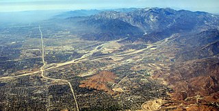
Mojave Heights is an unincorporated community in the Victor Valley of the Mojave Desert, within San Bernardino County, California.
Lytle Creek, California, is an approximately 18-mile-long (29 km) stream in southwestern San Bernardino County near the city of San Bernardino. It is a tributary of Warm Creek, a tributary of the Santa Ana River. The Mormon settlers of San Bernardino named the stream "Lytle Creek" after their leader, Captain Andrew Lytle.

The Mojave Road, also known as Old Government Road, is a historic route and present day dirt road across what is now the Mojave National Preserve in the Mojave Desert in the United States. This rough road stretched 147 miles (237 km) from Beale's Crossing, to Fork of the Road location along the north bank of the Mojave River where the old Mojave Road split off from the route of the Old Spanish Trail/Mormon Road.
The Black Butte River is located in the Mendocino National Forest of northern California in Glenn and Mendocino counties. It is a tributary to the Middle Fork Eel River and flows northward for 24 miles (39 km) from its headwaters near Round Mountain to the confluence with the Middle Fork Eel River. The Northern California Coastal Wild Heritage Wilderness Act of 2006 added 21 miles (34 km) of the Black Butte River to the National Wild and Scenic Rivers System, of which 17.5 miles (28.2 km) are Wild status and 3.5 miles (5.6 km) are Scenic.
North Fork Lytle Creek is a tributary of Lytle Creek in San Bernardino County, California.
Middle Fork Lytle Creek is a tributary of Lytle Creek in San Bernardino County, California.
Crowder Canyon, originally Coyote Canyon, is a valley in San Bernardino County, California. Its mouth was at an elevation of 2,999 feet / 914 meters at its confluence with Cajon Canyon. Its source was at an elevation of 4200 feet at 34°21′02″N117°26′04″W near Cajon Summit. The canyon runs southward just west of the top of Cajon Pass then turns southwestward to meet Cajon Canyon.
Summit Valley is a valley along SR 138 in the San Bernardino Mountains, east of Cajon Pass within San Bernardino County, California.

Deep Creek is a tributary of the Mojave River, 23.4 miles (37.7 km) long, in San Bernardino County, California.
Lower Narrows of the Mojave River, is a narrow gap the Mojave River passes through at Mojave Heights in San Bernardino County, California. It lies at an elevation of 2,746 feet / 837 meters.
Bryman, is a populated place in the central Mojave Desert, within San Bernardino County, California. It lies along the Mojave River in the northern Victor Valley, at an elevation of 2,526 feet . It is on the historic U.S. Route 66, 5 miles north of Oro Grande, and south of Helendale.
Salt Creek or Rio Salitroso is a tributary stream or wash of the Amargosa River, in San Bernardino County, California. It was named Jeff Salitroso, on January 16, 1830, by Antonio Armijo, whose expedition subsequently followed it up towards the Mojave River, as they established the first route of the Old Spanish Trail.
Sawpit Canyon is a steep valley or canyon in the San Bernardino Mountains of San Bernardino County, California. Its mouth is at an elevation of 3,386 feet / 1,032 meters. Its source is located at 34°14′43″N117°20′56″W and lies at an elevation of 5,100 feet, just east of Monument Peak. Its creek was a tributary of the West Fork Mojave River, its original mouth now under Silverwood Lake.
Cable Canyon is a valley on the south slope of the San Bernardino Mountains in San Bernardino County, California. Its mouth lies at an elevation of 2,073 feet / 632 meters. Its source is at 34°13′48″N117°22′19″W, the confluence of West Fork Cable Canyon and East Fork Cable Canyon, at an elevation of 2,671 feet / 814 meters.
Manix Wash is a 2.5 mile long tributary stream of the Mojave River, in San Bernardino County, California. Its mouth lies at an elevation of 1,621 feet /494 meters at its confluence with the river. Its source lies at an elevation of 1740 feet at 34°59′45″N116°34′43″W in the Mojave Valley.
Callville Wash is an ephemeral stream or wash in Clark County, Nevada. It was named for Callville the riverport settlement founded in 1866, at its mouth where it had its original confluence with the Colorado River.
Devil Canyon is a 1.5 mile long canyon on the south slope of the San Bernardino Mountains, in San Bernardino County, California. Its mouth lies at an elevation of 1,759 feet / 536 meters. It heads at 34°12′53″N117°19′43″W, the confluence of East Fork Devil Canyon and West Fork Devil Canyon at an elevation of 2,352 feet / 717 meters.


