Selsey is a seaside town and civil parish, about eight miles (12 km) south of Chichester, in the Chichester district, in West Sussex, England. Selsey lies at the southernmost point of the Manhood Peninsula, almost cut off from mainland Sussex by the sea. It is bounded to the west by Bracklesham Bay, to the north by Broad Rife, to the east by Pagham Harbour and terminates in the south at Selsey Bill. There are significant rock formations beneath the sea off both of its coasts, named the Owers rocks and Mixon rocks. Coastal erosion has been an ever-present problem for Selsey. In 2011 the parish had a population of 10,737.

Chichester Harbour is a large natural harbour in West Sussex and Hampshire. It is situated to the south-west of the city of Chichester and to the north of the Solent. The harbour and surrounding land has been designated as an Area of Outstanding Natural Beauty (AONB) and a biological and geological Site of Special Scientific Interest (SSSI). The area is also part of the Solent Maritime Special Area of Conservation, Chichester and Langstone Harbours Ramsar site, Special Protection Area and Nature Conservation Review site, Grade I. Part of it is a Geological Conservation Review site and two areas are Local Nature Reserves.

Earnley is a village and a civil and ecclesiastical parish in the Chichester District of West Sussex, England. It is located four miles (6.4 km) south-west of Chichester, and lies on the south coast of England. The parish includes the settlements of Almodington and Batchmere.

Aldingbourne is a village, Anglican parish and civil parish in the Arun District of West Sussex, England. Its centre is 4 miles (6.4 km) north of Bognor Regis and 4 miles (6.4 km) east of Chichester with the A29 and A27 main roads running through it.

Birdham is a village and civil parish in the Chichester District of West Sussex, England. It is located on the Manhood Peninsula, c. 5 miles (8.0 km) south-west of the city of Chichester. The parish church is dedicated to St James, although the dedication was to St. Leonard until c. 1900.

Lodsworth is a small village, ecclesiastical parish and civil parish in the Chichester district of West Sussex, England. It is situated between Midhurst and Petworth, half a mile north of the A272 road. It lies within the South Downs National Park, just to the north of the valley of the River Rother; a tributary stream the River Lod runs close to the east end of the village.

Nuthurst is a village and civil parish in the Horsham district of West Sussex, England. The north of the parish borders Horsham town, with Nuthurst village 3 miles (5 km) south from the border. Within the parish is the estate and largely 19th-century country house of Sedgwick Park.

Chidham and Hambrook is a civil parish in the Chichester district in West Sussex, England located approximately five miles (8 km) west of Chichester, south of the A27 road, near Bosham. In 2011 the parish had a population of 1356. Chidham is the ecclesiastical parish, with a slightly different boundary from that of the civil parish.

Fishbourne is a village and civil parish in the Chichester District of West Sussex, England and is situated two miles (3.2 km) west of Chichester.

West Wittering is a village and civil parish situated on the Manhood Peninsula in the Chichester district of West Sussex, England. It lies near the mouth of Chichester Harbour on the B2179 road 6.5 miles (10.5 km) southwest of Chichester close to the border with Hampshire. The sandy beach was described as having excellent water quality in 2017.

East Wittering is a large coastal village in the Chichester district of West Sussex, England. The majority of the village lies within the civil parish of East Wittering and Bracklesham, while the western edge lies within the boundary of West Wittering civil parish. The village sits on the B2179 road 7 miles (11 km) southwest of Chichester, on the Manhood Peninsula.

Salcombe Regis is a coastal village and former civil parish, now in the parish of Sidmouth, in the East Devon district, in the county of Devon, England. Mentioned in the Domesday Book as "a manor called Selcoma" held by Osbern FitzOsbern, bishop of Exeter, the manor house stood on the site now occupied by Thorn Farm. The thorn tree growing in an enclosure at the road junction above the farm marked the cultivation boundary between manor and common ground. In 1951 the parish had a population of 869. On 1 April 1974 the parish was abolished and merged with Sidmouth.

West Itchenor is a village and civil parish, on the Manhood Peninsula, in the Chichester District of West Sussex, England. It lies north of the B2179 Chichester to West Wittering road 4.5 miles (7.3 km) southwest of Chichester. The village lies on the shores of Chichester Harbour.

Halnaker is a hamlet in the Chichester district of West Sussex, England. It lies on the A285 road 3.5 miles (5.6 km) northeast of Chichester, where it follows the line of the Roman road to London called Stane Street. There is a pub, The Anglesey Arms. Goodwood House is southwest of the village. North of the village Halnaker Windmill stands on 128 metre/420 feet high Halnaker Hill, a southern outpost of the South Downs. It is in the civil parish of Boxgrove.

St. Nicholas Church is the Anglican parish church of West Itchenor, a village in the Chichester district of West Sussex, United Kingdom.

The Manhood Peninsula is in the southwest of West Sussex in England. It has the English Channel to its south and Chichester to the north. It is bordered to its west by Chichester Harbour and to its east by Pagham Harbour, its southern headland being Selsey Bill.

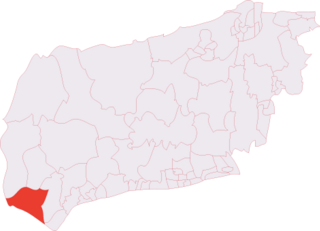
The Witterings is an electoral division of West Sussex in the United Kingdom, and returns one member to sit on West Sussex County Council.

St Wilfrid's Chapel, also known as St Wilfrid's Church and originally as St Peter's Church, is a former Anglican church at Church Norton, a rural location near the village of Selsey in West Sussex, England. In its original, larger form, the church served as Selsey's parish church from the 13th century until the mid 1860s; when half of it was dismantled, moved to the centre of the village and rebuilt along with modern additions. Only the chancel of the old church survived in its harbourside location of "sequestered leafiness", resembling a cemetery chapel in the middle of its graveyard. It was rededicated to St Wilfrid—7th-century founder of a now vanished cathedral at Selsey—and served as a chapel of ease until the Diocese of Chichester declared it redundant in 1990. Since then it has been in the care of the Churches Conservation Trust charity. The tiny chapel, which may occupy the site of an ancient monastery built by St Wilfrid, is protected as a Grade I Listed building.

The Grade I listed Saxon church of St Botolph's at Botolphs, West Sussex, England, is situated in the valley of the River Adur and is now part of the Church of England parish of Beeding and Bramber with Botolphs. An earlier dedication to St Peter de Vetere Ponte is now lost, like the bridge over the Adur from which it took this ancient name. The church serves the mostly depopulated hamlet of Botolphs in the Horsham district of West Sussex. The church has fragments of medieval wall paintings. Architectural historian Ian Nairn comments that the Jacobean pulpit is "notable in a county which is poor in 17th century fittings".


