This article needs additional citations for verification .(September 2015) (Learn how and when to remove this template message) |

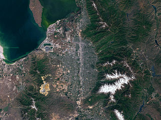
The East Jordan Canal is a historic waterway in Salt Lake County, Utah, United States. [1]
This article needs additional citations for verification .(September 2015) (Learn how and when to remove this template message) |
The East Jordan Canal is a historic waterway in Salt Lake County, Utah, United States. [1]
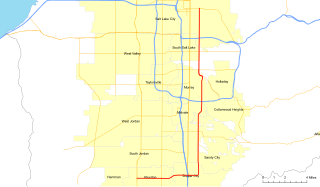
The canal is owned by Salt Lake City Public Utilities. [2] The canal exits the Jordan River at Turner Dam, along with the Utah and Salt Lake Canal. An extension of the canal was proposed in 2012, involving a partnership between Salt Lake City Public Utilities and the city of Cottonwood Heights that would result in the construction of a multi-use trail on top of the canal as it passes through an existing urban neighborhood.

Salt Lake County is a county in the U.S. state of Utah. As of the 2010 United States Census, the population was 1,029,655, making it the most populous county in Utah. Its county seat and largest city is Salt Lake City, the state capital. The county was created in 1850. Salt Lake County is the 37th most populated county in the United States and is one of four counties in the Rocky Mountains to make it into the top 100.

Federal Heights is an affluent neighborhood in Salt Lake City, Utah. It is generally considered as the residential area to the east of Virginia Street and to the north of South Temple Street in Salt Lake City. It abuts the Wasatch Mountains to the north, and the University of Utah to the south and east. Federal Heights is one of the most wealthy neighborhoods in Salt Lake City. Many of the homes in the area date to the early 1900s.

The Jordan River, in the state of Utah, United States, is a river about 51 miles (82 km) long. Regulated by pumps at its headwaters at Utah Lake, it flows northward through the Salt Lake Valley and empties into the Great Salt Lake. Four of Utah's six largest cities border the river: Salt Lake City, West Valley City, West Jordan and Sandy. More than a million people live in the Jordan Subbasin, which is the part of the Jordan River watershed that lies within Salt Lake and Utah counties. During the Pleistocene, the area was part of Lake Bonneville.

The Conference Center, in Salt Lake City, Utah, is the premier meeting hall for The Church of Jesus Christ of Latter-day Saints. Completed in 2000, the 21,000-seat Conference Center replaced the traditional use of the nearby Salt Lake Tabernacle, built in 1868, for semi-annual LDS Church General Conference and major church gatherings, devotionals, and other events. It is believed to be the largest theater-style auditorium ever built.
The Salt Lake City School District (SLCSD) is the oldest public school district in Utah. Boundaries for the district are identical to the city limits for Salt Lake City. Employing about 1,300 teachers who instruct about 25,000 students K-12, the district is the ninth largest in the state, as of 2009, behind Granite, Davis, Alpine, Jordan, Canyons, Weber, Nebo, and Washington. Two of the district's high schools, East and West, are over 100 years old.
Salt Lake Valley is a 500-square-mile (1,300 km2) valley in Salt Lake County in the north-central portion of the U.S. state of Utah. It contains Salt Lake City and many of its suburbs, notably Murray, Sandy, South Jordan, West Jordan, and West Valley City; its total population is 1,029,655 as of 2010. Brigham Young said "this is the right place", when he and his fellow settlers moved into Utah after being driven out of several states.

City Creek is a small but historically important mountain stream that flows from City Creek Canyon and across part of Salt Lake City, Utah, and into the Jordan River which empties into the Great Salt Lake. City Creek's head is about 8 miles (13 km) up City Creek Canyon northeast of Downtown Salt Lake City. The entire stream measures only about 14.5 miles (23 km) long. Melting snow from adjacent mountains provides most of City Creek's currents, but the stream flows year-round because of natural springs at the head of the creek.
The Granite School District spreads across central Salt Lake County, Utah, serving West Valley City, Millcreek, Taylorsville, South Salt Lake, and Holladay; Kearns and Magna Townships; and parts of West Jordan, Murray and Cottonwood Heights. About 67,000 students are enrolled in its programs ranging from kindergarten to twelfth grade. It operates 8 high schools, 16 junior high schools, 62 elementary schools, as well as several specialty schools. This makes Granite the second largest school district in the state of Utah behind Alpine School District in Utah County. Other school districts in the area include the Salt Lake City School District and the Murray School District.

Big Cottonwood Canyon is a canyon in the Wasatch Range 12 miles (19 km) southeast of Salt Lake City in the U.S. state of Utah. The 15-mile (24 km)-long canyon provides hiking, biking, picnicking, rock-climbing, camping and fishing in the summer. Its two ski resorts, Brighton and Solitude, are popular among skiers and snowboarders. The canyon is accessed by The Big Cottonwood Canyon Scenic Byway (SR-190), which runs its length to Guardsman Pass at the top of the canyon, allowing travel to Park City in the summer months.
The Unified Fire Authority of Greater Salt Lake provides fire protection and emergency medical services for the unincorporated Salt Lake County, Utah as well as for 9 cities located within the Salt Lake Metropolitan Area. These cities include Alta, Cottonwood Heights, Eagle Mountain, Herriman, Holladay, Midvale, Riverton and Taylorsville.
State Route 71 (SR-71) is a state highway completely within the Salt Lake City metropolitan area in the northern portion of the US state of Utah. It runs from SR-154 in the southwest side of the city to SR-186 in Downtown Salt Lake City. The route spans 22.47 miles (36.16 km) as it runs along portions of 12600 South, 12300 South, 900 East, and 700 East streets.

The Traverse Mountains, or sometimes Traverse Range, are an anomalous, geologically complex, east-trending range that separates Salt Lake Valley and Utah Valley in Salt Lake and Utah counties in the U.S. State of Utah.

The Oquirrh Mountain Utah Temple is a temple of The Church of Jesus Christ of Latter-day Saints located in South Jordan, Utah, a suburb of Salt Lake City. South Jordan was the first city in the world to have two temples. The temple was the fourth in the Salt Lake Valley and the 13th in the state of Utah.

The Jordan River Parkway is an approximately 40-mile (64 km) urban park that runs along the Jordan River within the U.S. state of Utah. The parkway follows along the river from Utah Lake in Utah County, through Salt Lake County and onto the Great Salt Lake in Davis County. The majority of a mixed-use trail has been completed with a shared-use path for cyclists, skaters, and joggers. A separate equestrian path runs on the southern portion of the trail. Many trail-heads, city and county parks and golf courses are also located along the parkway.
Canyons School District is a school district in the southern portion of Salt Lake County in Utah, United States. The district serves the communities of Alta, Cottonwood Heights, Draper, Midvale and Sandy. Residents of those communities voted to create the district in 2007, making Canyons the first school district to be formed in the state in almost a century. Canyons has approximately 33,000 students in 44 schools. There are 29 elementary schools, eight middle schools, five high schools, and four special programs schools, including one technical school, a special education school and a high school for adults in prison. The district covers 192 square miles and employs 6,000 people.

East Bench in Salt Lake City, Utah is a relatively affluent and primarily residential neighborhood of Salt Lake City that lies at the base of the Wasatch Range and extends west to approximately 1500 East. Foothill is the northern part of this area, divided by Interstate 80, and takes its name from the area's major traffic artery of Foothill Drive, which runs parallel to the base of the mountains and connects Interstate 80 with the University of Utah and downtown Salt Lake City. The East Bench is bordered on the north by the Federal Heights neighborhood and on the south by the Traverse Mountains. This neighborhood becomes increasingly affluent moving from west to east. The University of Utah sits at the north end of this neighborhood. Points of interest include the Hogle Zoo, Red Butte Garden and Arboretum, This Is The Place Heritage Park, Fort Douglas Military Museum and the Foothill Village Shopping Center. Some notable residents and former residents include numerous authorities of The Church of Jesus Christ of Latter-day Saints, LDS speaker John Bytheway, and billionaire philanthropist Jon Huntsman, Sr..

Fort Union, historically Union, is a major commercial area and an early settlement in the Salt Lake Valley of Utah that is now split between the municipalities of Midvale, Cottonwood Heights, and Sandy. The fort after which the area was named was built early (1853) in the Salt Lake Valley's post-1847 history at a strategic point where escarpments on either side of the Little Cottonwood Creek valley create a narrow gateway to the upper valley and Little Cottonwood Canyon beyond. The effects of geography on travel through the area have also contributed to the area's much more recent success as a retail and employment destination.

The Jordan and Salt Lake City Canal is a 28-mile (45 km) historic waterway in Salt Lake County, Utah, United States.
The Utah and Salt Lake Canal is an historic waterway in Salt Lake County, Utah, United States.

Marie H. Poulson is an American politician and a Democratic member of the Utah House of Representatives representing District 46 since January 1, 2009. Marie lives in Salt Lake City with her husband, Daniel, and their five children.
![]()
Coordinates: 40°36′58″N111°52′16″W / 40.6160589°N 111.8710456°W
| This article about transportation in Utah is a stub. You can help Wikipedia by expanding it. |