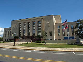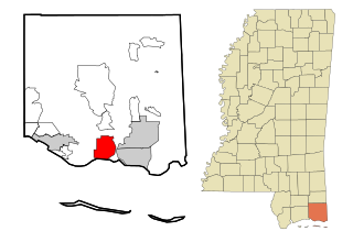
Jackson County is a county located in the U.S. state of Mississippi. As of the 2020 census, the population was 143,252, making it the fifth-most populous county in Mississippi. Its county seat is Pascagoula. The county was named for Andrew Jackson, general in the United States Army and afterward President of the United States. Jackson County is included in the Pascagoula, MS Metropolitan Statistical Area. It is located at the southeastern tip of the state. The county has sandy soil and is in the Piney Woods area. It borders the state of Alabama on its east side. The county was severely damaged by both Hurricane Camille in August 1969 and Hurricane Katrina on August 29, 2005, which caused catastrophic effects.

Gautier is a city in Jackson County, Mississippi, United States, along the Gulf of Mexico west of Pascagoula. It is part of the Pascagoula Metropolitan Statistical Area. The population was 18,572 at the 2010 census, up from 11,681 at the 2000 census. In 2002, Gautier had annexed land more than doubling its area.

Moss Point is a city in Jackson County, Mississippi, United States. The population was 12,147 in 2020, a decline from the figure of 13,704 in 2010. The Moss Point Historic District and several individual buildings are listed on the National Register of Historic Places' Jackson County listings.

Pascagoula is a city in and the county seat of Jackson County, Mississippi, United States. It is the principal city of the Pascagoula metropolitan area, and is part of the Gulfport–Biloxi–Pascagoula Combined Statistical Area and the Gulfport-Biloxi metropolitan area. The population was 22,392 at the 2010 census, down from 26,200 at the 2000 census. In 2019 the population was 21,699.

Ingalls Shipbuilding is a shipyard located in Pascagoula, Mississippi, United States, originally established in 1938, and now part of HII. It is a leading producer of ships for the United States Navy, and, as of 2023, is the largest private employer in Mississippi.
The Pascagoula were an indigenous group living in coastal Mississippi on the Pascagoula River.

Naval Station Pascagoula was a base of the United States Navy, in Pascagoula, Mississippi. The base officially closed 15 November 2006. The base's property, on Singing River Island in the Mississippi Sound at the mouth of the Pascagoula River, was formally transferred to the Mississippi Secretary of State's office 9 July 2007.

Round Island is a small, uninhabited island in the Mississippi Sound, 6.5 kilometres south of Pascagoula, Mississippi, U.S.A. The island is a coastal preserve, situated in Jackson County and managed by the Mississippi Department of Marine Resources. The relatively isolated terrain—consisting of slash pine forest, interior marsh, and sandy beach—provides feeding, resting, and wintering habitat for migratory birds, including the brown pelican, white pelican, and cormorants. A number of rare or endangered species, including the Ruellia noctiflora, are found there.

Ship Island is a barrier island off the Gulf Coast of Mississippi, one of the Mississippi–Alabama barrier islands. Hurricane Camille split the island into two separate islands in 1969. In early 2019, the US Army Corps of Engineers completed the first stage of a project rejoining the two islands and recreating one Ship Island. Ship Island is the site of Fort Massachusetts, as a Third System fortification. Part of the island is included in the Gulf Islands National Seashore.

The Pascagoula River is a river, about 80 miles (130 km) long, in southeastern Mississippi in the United States. The river drains an area of about 8,800 square miles (23,000 km²) and flows into Mississippi Sound of the Gulf of Mexico. The Pascagoula River Basin is managed by the Pat Harrison Waterway District.

The Ladies Delight Light is a small lighthouse on Lake Cobbosseecontee, in Winthrop, Maine, United States. It was constructed in 1908 and is believed to be the only active inland waters lighthouse in Maine. The tower is 25 feet (7.6 m) tall, and is equipped with a solar powered dual-level LED marine beacon. It operates every night of the year. At the time of its construction, it was the only inland lake lighthouse east of the Mississippi River. It was listed on the National Register of Historic Places in 1984.

Interstate 10 (I-10), a major east–west Interstate Highway in the southern areas of the United States, has a section of about 77 miles (124 km) in Mississippi.
The Pascagoula-Gautier School District is a public school system based in Pascagoula, Mississippi.

The Pearl River map turtle is a species of emydid turtle native to the southern United States. According to a study done in January 2017, the species G. pearlensis was significantly less abundant in the Pearl River region as compared to G. oculifera and exhibited a smaller number of reproductively mature females. Further, this study highlighted statistical and observational evidence that this species exhibited female-biased, sexual dimorphism.

Round Island Lighthouse stood from 1859 to 1998 on the southwest end of Round Island in the Mississippi Sound, 4 miles (6.4 km) south of Pascagoula, Mississippi. In September 1998, the lighthouse was toppled by Hurricane Georges. In 2010, the base of the structure and other lighthouse remnants were removed from Round Island and relocated within the City of Pascagoula for restoration.

The Lake Borgne Light was a lighthouse in Mississippi at the entrance to Lake Borgne on what is now Lighthouse Point, east of Heron Bay. It was built in 1889 to replace an earlier light on St. Joseph's Island further east, which was shrinking and is now completely gone. The new light sat on a screwpile foundation in the marsh and was reached by a boardwalk; it was equipped with a fifth order Fresnel lens. The house was destroyed by the 1906 Mississippi hurricane but was rebuilt; it was deactivated in 1937 and abandoned. The foundation of the light is marked as a hazard on present day charts, as the point of land has eroded further.

The Horn Island Light was a lighthouse in Mississippi originally located at the eastern end of Horn Island. Moved and rebuilt several times, it was deactivated and abandoned in 1961.


