
Austhorpe is a civil parish and residential suburb of east Leeds, West Yorkshire, England. It is 5 miles (8 km) to the east of city centre and close to the A6120 dual carriageway and the M1 motorway.

Halton is a district of east Leeds, West Yorkshire, England, situated between Cross Gates to the north, Halton Moor to the west, Colton to the east and Whitkirk to the South. Temple Newsam lies directly south of the estate.

Trunch is a village and parish in Norfolk, England, situated three miles north of North Walsham and two miles from the coast at Mundesley. At the Census 2011 the village had a population of 909. The parish covers an area of 5.5 square kilometres (2.1 sq mi).

Allerton Bywater is a semi-rural village and civil parish in the south-east of the City of Leeds metropolitan borough in West Yorkshire, England. The population of the civil parish at the 2011 census was 4,717. The village itself is 2 miles (3.2 km) north of Castleford, with neighbouring villages Kippax and Great Preston all providing local amenities. St Aidan's Nature reserve borders the village attracting many visitors with its beauty and charm. Additionally "The Lines Way" bridle path which runs from Garforth through to Allerton following the old train track provides a pleasant route for walkers, joggers and cyclists alike. The River Aire flows through the village to the south-west.
Colton is a district of east Leeds, West Yorkshire, England, situated between Cross Gates to the north, Halton and Halton Moor to the west, Whitkirk to the north-west and Austhorpe to the north-east. Temple Newsam lies directly south of the estate.

Bardsey cum Rigton is a civil parish in the City of Leeds metropolitan borough in West Yorkshire, England. According to the 2001 census it had a population of 2,385, increasing to 2,525 at the 2011 Census. The parish includes the villages of Bardsey, East Rigton and Thornhurst.

Carlton is a village in the south of the City of Leeds metropolitan borough in West Yorkshire, England, about 6 miles (13 km) from Leeds city centre.

Great Preston is a small rural village in the City of Leeds metropolitan borough, West Yorkshire, England. It has incorporated the once neighbouring hamlet of Little Preston.

Wetherby was a rural district in the West Riding of Yorkshire from 1894 to 1974. It was named after the town of Wetherby.

Latrigg is one of the lowest fells in the Lake District in North West England, but is a popular climb due to its convenient location overlooking the town of Keswick and the beautiful views down the valley of Borrowdale from the summit. It is the least mountainous of the Skiddaw fells, the summit being almost entirely devoid of rock. The slopes of Latrigg are partially wooded, and logging work is currently being undertaken. One lone tree just south of the summit is prominently viewed in silhouette when approaching Keswick from the west along the A66. It also has petrified trees on top.

Collingham is a village and civil parish 2 miles (3 km) south-west of Wetherby in West Yorkshire, England. It is in the City of Leeds metropolitan borough. The population of the civil parish as of the 2011 census was 2,991.

Bardsey, West Yorkshire, England is a small village in the City of Leeds metropolitan borough, 8 miles (13 km) north east of Leeds city centre. The village is in the LS17 Leeds postcode district. It is part of the civil parish of Bardsey cum Rigton. The village itself lies just off the A58 road between Leeds and Wetherby.

East Keswick is a village and civil parish in the City of Leeds metropolitan borough, West Yorkshire, England. It lies four miles south west of Wetherby. The population of the civil parish as of the 2011 census was 1,146.

Bagley is a village in the City of Leeds metropolitan borough, West Yorkshire, England, once in the township of Farsley. The remains of the village are on Bagley Lane, on the section between the A657 road in Rodley and the junction with Coalhill Lane.

Moor Allerton is an area of Leeds, West Yorkshire, England. The area is situated in North Leeds, near to King Lane and the Leeds Outer Ring Road.
Middleton is a settlement and civil parish in Northumberland, England. The parish is situated on the North Sea coast, south of the island of Lindisfarne, and contains the villages of Ross, Detchant and Elwick; all are shrunken medieval villages. Both the A1 London to Edinburgh road and East Coast Main Line pass through the parish. In the 2001 census the parish had a population of 136, falling to 115 at the 2011 Census.

The Calls is an area and street by the River Aire in Leeds city centre, West Yorkshire, England. This district falls within the City and Hunslet ward of the City of Leeds Council. Formerly an area of industry in Leeds, it has now been regenerated with a mixture of uses: primarily offices, residential and leisure.

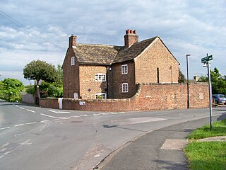
Carlton is a civil parish in the City of Leeds in West Yorkshire, England. It consists of the villages of East Carlton and West Carlton, and in 2001 had a population of 169.
Bardsey cum Rigton is a civil parish in the metropolitan borough of the City of Leeds, West Yorkshire, England. It contains 16 listed buildings that are recorded in the National Heritage List for England. Of these, one is listed at Grade I, the highest of the three grades, and the others are at Grade II, the lowest grade. The parish contains the villages of Bardsey, and East Rigton, and is otherwise rural. The most important listed building is All Hallows Church which contains Anglo-Saxon material, and is listed at Grade I. The other listed buildings consist of houses and cottages, farmhouses and farm buildings, a sundial in the churchyard, a public house, and a milestone.

