
Cambridgeshire is a ceremonial county in the East of England. It is bordered by Lincolnshire to the north, Norfolk to the north-east, Suffolk to the east, Essex and Hertfordshire to the south, and Bedfordshire and Northamptonshire to the west. The largest settlement is the city of Peterborough, and the city of Cambridge is the county town.

Cambridge is a city and non-metropolitan district in the county of Cambridgeshire, England. It is the county town of Cambridgeshire and is located on the River Cam, 55 miles (89 km) north of London. As of the 2021 United Kingdom census, the population of the City of Cambridge was 145,700; the population of the wider built-up area was 181,137. Cambridge became an important trading centre during the Roman and Viking ages, and there is archaeological evidence of settlement in the area as early as the Bronze Age. The first town charters were granted in the 12th century, although modern city status was not officially conferred until 1951.

East Anglia is an area in the East of England, often defined as including the counties of Norfolk, Suffolk and Cambridgeshire. The name derives from the Anglo-Saxon kingdom of the East Angles, a people whose name originated in Anglia, in what is now Northern Germany.

Anglia Ruskin University (ARU) is a public university in East Anglia, United Kingdom. Its origins are in the Cambridge School of Art (CSA), founded by William John Beamont, a Fellow of Trinity College at University of Cambridge, in 1858. It became a university in 1992, and was renamed after John Ruskin, the Oxford University professor and author, in 2005. Ruskin gave the inauguration speech of the Cambridge School of Art in 1858. It is one of the "post-1992 universities". The motto of the university is in Latin Excellentia per societatem, in English Excellence through partnership.
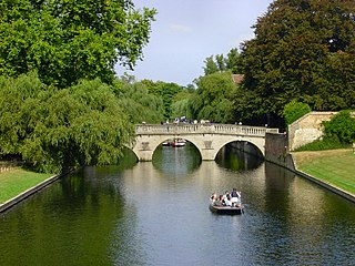
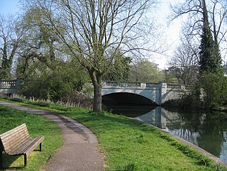
The River Cam is the main river flowing through Cambridge in eastern England. After leaving Cambridge, it flows north and east before joining the River Great Ouse to the south of Ely, at Pope's Corner. The total distance from Cambridge to the sea is about 40 mi (64 km) and is navigable for punts, small boats, and rowing craft. The Great Ouse also connects to England's canal system via the Middle Level Navigations and the River Nene. In total, the Cam runs for around 69 kilometres (43 mi) from its furthest source to its confluence with the Great Ouse.

Cam FM is a student-run radio station at the University of Cambridge and Anglia Ruskin University. The station broadcasts online and has an FM frequency of 97.2 MHz. The station opened studios at Anglia Ruskin University and Fitzwilliam College and started broadcasting in 2012 from these locations after having spent its first 32 years located in Churchill College. Cam FM once held the world record for the longest team broadcast marathon, at 76 hours, and following the significant technical overhaul as a result of the two new studios in 2012, provided the first-ever broadcast media coverage of the Oxford vs Cambridge Women's Boat Race from Dorney Lake, as well as live outside broadcasts from Newmarket Races and the Varsity Ski Trip.
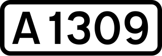
The A1309 is a short road which links the two ends of the A10 to north and south of Cambridge city centre in Cambridgeshire, England. It was numbered as part of the A10 prior to the construction of the Cambridge Western Bypass and the Northern Bypass.

Thetford railway station is on the Breckland line in the east of England, serving the market town of Thetford, Norfolk. The line runs between Cambridge in the west and Norwich in the east.
Peterborough College, established in 1946 as Peterborough Technical College, is a major further education college in Peterborough, Cambridgeshire, United Kingdom.
Mill Road is a two-lane road in southeast Cambridge, England. It runs southeast from near to Parker's Piece, at the junction with Gonville Place, East Road, and Parkside. It crosses the main railway line and links to the city's ring road. It passes through the wards of Petersfield and Romsey, which are divided by the railway line. It is a busy road containing many independent businesses, churches, hospital and Cambridge Central Mosque.
Trumpington Street is a major historic street in central Cambridge, England. At the north end it continues as King's Parade where King's College is located. To the south it continues as Trumpington Road, an arterial route out of Cambridge, at the junction with Lensfield Road.

Trumpington Road is an arterial road in southeast central Cambridge, England. It runs between the junction of Trumpington Street and Lensfield Road at the northern end to the junction of the High Street in the village of Trumpington and Long Road at the southern end. The Fen Causeway leads off to the west near the northern end, over Coe Fen and the River Cam.

Queen's Road is a major road to the west of central Cambridge, England. It links with Madingley Road and Northampton Street to the north and with Sidgwick Avenue, Newnham Road and Silver Street to the south.

Northampton Street is a street in the north of central Cambridge, England. It runs between Madingley Road and Queen's Road to the west and Castle Street, by Castle Hill, Chesterton Lane, and Magdalene Street to the east.
Gonville Place is a road in southeast central Cambridge, England. It forms part of the city's inner ring road. At the southwest end is the junction of Regent Street and Hills Road, where the road continues as Lensfield Road. At the northeast end is the junction of Parkside and Mill Road, where the road continues as East Road, a dual carriageway.

Elizabeth Way is a road in northeast Cambridge, England. It is designated the A1134 and forms part of Cambridge's inner ring road. At the northern end is a roundabout forming a junction with Milton Road. Near the north end is another roundabout linking with Chesterton Road to the west. At the southern end there is a roundabout that links with East Road and Newmarket Road.

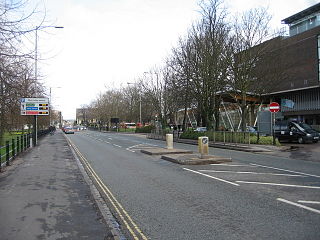
Newmarket Road is an arterial road in the east of Cambridge, England. It is designated the A1134 at the western end, linked by a roundabout forming a junction with Barnwell Road (A1134) to the south. The eastern end links with the city's inner ring road at another roundabout, with Elizabeth Way (A1134) to the north and East Road (A603) to the southeast. Newmarket Road continues a short way towards the city centre, becoming Maid's Causeway and then Jesus Lane. To the east, the road becomes the A1303 and crosses the A14 at a major roundabout, continuing further east and parallel to the A14 out of the city. The road is named after the market town of Newmarket in Suffolk, east of Cambridge.

Victoria Road is a residential road in the north of Cambridge, England. The road is designated the A1134. At the western end, the road links with Histon Road, Huntingdon Road, Mount Pleasant, and Castle Street.In 1950, there were plans to improve this junction, but they never came to fruition. At the eastern end it links with Chesterton Road (A1303) and also links to Milton Road, the A1134, then A1309, northeast out of the city, also linking with the A14.
Fen Causeway is a link road in the city of Cambridge, United Kingdom, constructed in the mid-1920s to ease the pressure on Silver Street. It forms part of the A1134 ring road. It links Newnham Road and Trumpington Road and spans the River Cam with Sheep's Green to the south and Coe Fen to the north. There is little residential development on this road.
University Centre Peterborough is a higher education institution with campuses in Peterborough and Stamford, Lincolnshire in the United Kingdom. It is formally part of the Inspire Education Group. Degrees at the Peterborough Campus are accredited by The Open University. The Stamford Campus has a range of courses accredited by Bishop Grosseteste University.


