
South Georgia and the South Sandwich Islands (SGSSI) is a British Overseas Territory in the southern Atlantic Ocean. It is a remote and inhospitable collection of islands, consisting of South Georgia and a chain of smaller islands known as the South Sandwich Islands. South Georgia is 165 km (103 mi) long and 35 km (22 mi) wide and is by far the largest island in the territory. The South Sandwich Islands lie about 700 km (430 mi) southeast of South Georgia. The territory's total land area is 3,903 km2 (1,507 sq mi). The Falkland Islands are about 1,300 km (810 mi) north-west from its nearest point.

The Shag Rocks are six small islands in the westernmost extreme of South Georgia, 240 km (150 mi) west of the main island of South Georgia and 1,000 km (620 mi) off the Falkland Islands. The Shag Rocks are located at 53°33′S42°02′W. 16 kilometres (9.9 mi) further southeast is Black Rock. Black Rock is located at 53°39′S41°48′W.

Zavodovski Island is an uninhabited volcanic island in the Traversay Islands subgroup of the South Sandwich Islands. It lies 350 kilometres (217 mi) southeast of South Georgia Island. It is the northernmost of the South Sandwich Islands and the nearest to South Georgia.

The South Orkney Islands are a group of islands in the Southern Ocean, about 604 kilometres (375 mi) north-east of the tip of the Antarctic Peninsula and 844 kilometres (524 mi) south-west of South Georgia Island. They have a total area of about 620 square kilometres (240 sq mi). The islands are claimed both by Britain, and by Argentina as part of Argentine Antarctica. Under the 1959 Antarctic Treaty, sovereignty claims are held in abeyance.

Bristol Island is an 8 km (5-mile) long island lying midway between Montagu Island and Thule Island in the South Sandwich Islands.

The Scotia Plate is a tectonic plate on the edge of the South Atlantic and Southern Ocean. Thought to have formed during the early Eocene with the opening of the Drake Passage that separates South America from Antarctica, it is a minor plate whose movement is largely controlled by the two major plates that surround it: the South American plate and Antarctic plate.
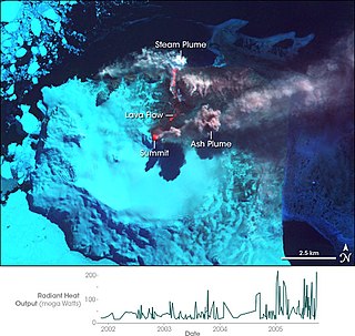
Mount Belinda is a stratovolcano on Montagu Island, in the South Sandwich Islands of the Scotia Sea. A part of the British Overseas Territory, South Georgia and the South Sandwich Islands, Mount Belinda is also the highest peak in the South Sandwich Islands, at 1,370 m.

The Traversay Islands are a group of three islands—Zavodovski, Leskov and Visokoi—at the northern end of the South Sandwich Islands.

The geology of Australia includes virtually all known rock types and from all geological time periods spanning over 3.8 billion years of the Earth's history. Australia is a continent situated on the Indo-Australian Plate.
The Ontong Java Plateau (OJP) is a huge oceanic plateau located in the south-west Pacific Ocean, north of the Solomon Islands. The OJP was emplaced c. 120 Ma with a much smaller volcanic event c. 90 Ma. Two other south-west Pacific plateaus, Manihiki and Hikurangi, now separated from the OJP by Cretaceous ocean basins, are of similar age and composition and probably formed as a single plateau and a contiguous large igneous province together with the OJP. When emplaced this Ontong Java-Manihiki-Hikurangi plateau covered 1% of Earth's surface and represented a volume of 80,000,000 km3 (19,000,000 cu mi) of basaltic magma. This "Ontong Java event", first proposed in 1991, represents the largest volcanic event of the past 200 million years, with a magma emplacement rate estimated at up to 22 km3 (5.3 cu mi)/year over three million years, several times larger than the Deccan Traps. The smooth surface of the OJP is punctuated by seamounts such as the Ontong Java Atoll, the largest atoll in the world.
The Nova Scotia peninsula is a peninsula on the Atlantic coast of North America.
Black Rock is a low rock 10 miles (16 km) southeast of Shag Rocks and some 105 miles (169 km) west-northwest of South Georgia. Black Rock may have been considered as part of the "Aurora Islands" reported in this vicinity by the ship Aurora in 1762. It was charted in 1927 by Discovery Investigations personnel on the William Scoresby.

The South Sandwich Plate or Sandwich Plate is a minor tectonic plate bounded by the subducting South American Plate to the east, the Antarctic Plate to the south and the Scotia Plate to the west. The plate is separated from the Scotia Plate by the East Scotia Rise, a back arc spreading ridge formed by the subduction zone on its eastern margin.

The Scotia Arc is the island arc system forming the north, east and south border of the Scotia Sea. The northern border, the North Scotia Ridge, comprises Isla de los Estados at the tip of Tierra del Fuego, the Burdwood, Davis, and Aurora Banks; the Shag, South Georgia Island and Clerke Rocks. The eastern border comprises the volcanic South Sandwich Islands flanked by the South Sandwich Trench. The southern border, the South Scotia Ridge, comprises Herdman, Discovery, Bruce, Pirie, and Jane Banks; the South Orkney Islands and Elephant Island. The Bransfield Strait, finally, separates the arc from the South Shetland Islands and James Ross Island flanking the tip of the Antarctic Peninsula.

The following outline is provided as an overview of and topical guide to South America.

The South American–Antarctic Ridge is the tectonic spreading center between the South American Plate and the Antarctic Plate. It runs along the sea-floor from the Bouvet Triple Junction in the South Atlantic Ocean south-westward to a major transform fault boundary east of the South Sandwich Islands. Near the Bouvet Triple Junction the spreading half rate is 9 mm/a (0.35 in/year), which is slow, and the SAAR has the rough topography characteristic of slow-spreading ridges.

The Shetland Plate is a tectonic microplate located off the tip of the Antarctic Peninsula and contains the South Shetland Islands. The plate is bordered on three sides by the Antarctic Plate and the fourth side is bordered by the Scotia Plate. The northwestern border is defined by the South Shetland Trench separating the Shetland Plate to the south from the Antarctic Plate to the north. This trench is the remnant of a subduction zone where the defunct Phoenix Plate, now part of the Antarctic Plate, subducted under the Antarctic Peninsula and the Shetland Islands. The southeastern border is rift zone with the Antarctic Plate creating the Bransfield Basin. The southwestern and northeastern boundaries are each part of larger fracture zones. The southwestern border is the Hero Fracture Zone and separates the Antarctic Plate to the southwest from the Shetland Plate to the northeast. The northeastern boundary is the Shackleton Fracture Zone and separates the Shetland Plate to the southwest from the Scotia Plate.

The Northeast Georgia Rise is an oceanic plateau located in the South Atlantic Ocean northeast of South Georgia Island and west of the Falkland Plateau.
The geology of South Georgia and the South Sandwich Islands is part of the largely submerged Scotia Ridge. The island of South Georgia is unusual among oceanic islands for having pre-Cretaceous sedimentary rocks underlying much of the island and a significant portion of felsic igneous rocks. Two-thirds of the island consists of intensely folded flysch, capped with Aptian age fossils, tuff and greywacke in the Cumberland Bay Series. The series includes slate, phyllite, conglomerate, siltstone and sandstone. In the west are basalt flows, pillowed spilite, prehnite and trachyandesite, as well as shale with radiolarite fossils.


