The Alps form part of a Cenozoic orogenic belt of mountain chains, called the Alpide belt, that stretches through southern Europe and Asia from the Atlantic all the way to the Himalayas. This belt of mountain chains was formed during the Alpine orogeny. A gap in these mountain chains in central Europe separates the Alps from the Carpathians to the east. Orogeny took place continuously and tectonic subsidence has produced the gaps in between.

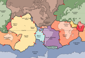
The Scotia Plate is a minor tectonic plate on the edge of the South Atlantic and Southern oceans. Thought to have formed during the early Eocene with the opening of the Drake Passage that separates Antarctica and South America, it is a minor plate whose movement is largely controlled by the two major plates that surround it: the Antarctic Plate and the South American Plate. The Scotia Plate takes its name from the steam yacht Scotia of the Scottish National Antarctic Expedition (1902–04), the expedition that made the first bathymetric study of the region.

The islands of Japan are primarily the result of several large ocean movements occurring over hundreds of millions of years from the mid-Silurian to the Pleistocene, as a result of the subduction of the Philippine Sea Plate beneath the continental Amurian Plate and Okinawa Plate to the south, and subduction of the Pacific Plate under the Okhotsk Plate to the north.

A mid-ocean ridge (MOR) is a seafloor mountain system formed by plate tectonics. It typically has a depth of about 2,600 meters (8,500 ft) and rises about 2,000 meters (6,600 ft) above the deepest portion of an ocean basin. This feature is where seafloor spreading takes place along a divergent plate boundary. The rate of seafloor spreading determines the morphology of the crest of the mid-ocean ridge and its width in an ocean basin.
The Pan-African orogeny was a series of major Neoproterozoic orogenic events which related to the formation of the supercontinents Gondwana and Pannotia about 600 million years ago. This orogeny is also known as the Pan-Gondwanan or Saldanian Orogeny. The Pan-African orogeny and the Grenville orogeny are the largest known systems of orogenies on Earth. The sum of the continental crust formed in the Pan-African orogeny and the Grenville orogeny makes the Neoproterozoic the period of Earth's history that has produced most continental crust.

The Phoenix Plate was a tectonic plate that existed during the early Paleozoic through late Cenozoic time. It formed a triple junction with the Izanagi and Farallon plates in the Panthalassa Ocean as early as 410 million years ago, during which time the Phoenix Plate was subducting under eastern Gondwana.

A back-arc basin is a type of geologic basin, found at some convergent plate boundaries. Presently all back-arc basins are submarine features associated with island arcs and subduction zones, with many found in the western Pacific Ocean. Most of them result from tensional forces, caused by a process known as oceanic trench rollback, where a subduction zone moves towards the subducting plate. Back-arc basins were initially an unexpected phenomenon in plate tectonics, as convergent boundaries were expected to universally be zones of compression. However, in 1970, Dan Karig published a model of back-arc basins consistent with plate tectonics.

The geology of the Rocky Mountains is that of a discontinuous series of mountain ranges with distinct geological origins. Collectively these make up the Rocky Mountains, a mountain system that stretches from Northern British Columbia through central New Mexico and which is part of the great mountain system known as the North American Cordillera.

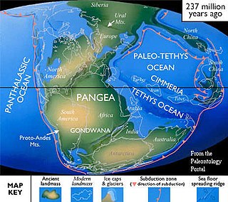
Cimmeria was an ancient continent, or, rather, a string of microcontinents or terranes, that rifted from Gondwana in the Southern Hemisphere and was accreted to Eurasia in the Northern Hemisphere. It consisted of parts of present-day Turkey, Iran, Afghanistan, Pakistan, Tibet, China, Myanmar, Thailand, and Malaysia. Cimmeria rifted from the Gondwanan shores of the Paleo-Tethys Ocean during the Early Permian and as the Neo-Tethys Ocean opened behind it, during the Permian, the Paleo-Tethys closed in front of it. Because the different chunks of Cimmeria drifted northward at different rates, a Meso-Tethys Ocean formed between the different fragments during the Cisuralian. Cimmeria rifted off Gondwana from east to west, from Australia to the eastern Mediterranean. It stretched across several latitudes and spanned a wide range of climatic zones.

The South Sandwich Plate or the Sandwich Plate is a small tectonic plate (microplate) bounded by the subducting South American Plate to the east, the Antarctic Plate to the south, and the Scotia Plate to the west. The plate is separated from the Scotia Plate by the East Scotia Rise, a back-arc spreading ridge formed by the subduction zone on its eastern margin. The South Sandwich Islands are located on this microplate.

The Scotia Arc is the island arc system forming the north, east and south border of the Scotia Sea. The northern border, the North Scotia Ridge, comprises Isla de los Estados at the tip of Tierra del Fuego, the Burdwood, Davis, and Aurora Banks; the Shag, South Georgia Island and Clerke Rocks. The eastern border comprises the volcanic South Sandwich Islands flanked by the South Sandwich Trench. The southern border, the South Scotia Ridge, comprises Herdman, Discovery, Bruce, Pirie, and Jane Banks; the South Orkney Islands and Elephant Island. The Bransfield Strait, finally, separates the arc from the South Shetland Islands and James Ross Island flanking the tip of the Antarctic Peninsula.

The South American–Antarctic Ridge or simply American-Antarctic Ridge is the tectonic spreading center between the South American Plate and the Antarctic Plate. It runs along the sea-floor from the Bouvet Triple Junction in the South Atlantic Ocean south-westward to a major transform fault boundary east of the South Sandwich Islands. Near the Bouvet Triple Junction the spreading half rate is 9 mm/a (0.35 in/year), which is slow, and the SAAR has the rough topography characteristic of slow-spreading ridges.

Located in the western Pacific Ocean near Indonesia, the Molucca Sea Plate has been classified by scientists as a fully subducted microplate that is part of the Molucca Sea Collision Complex. The Molucca Sea Plate represents the only known example of divergent double subduction (DDS), which describes the subduction on both sides of a single oceanic plate.

The Northeast Georgia Rise is an oceanic plateau located in the South Atlantic Ocean northeast of South Georgia Island and west of the Falkland Plateau.
The geology of the Baltic Sea is characterized by having areas located both at the Baltic Shield of the East European Craton and in the Danish-North German-Polish Caledonides. Historical geologists make a distinction between the current Baltic Sea depression, formed in the Cenozoic era, and the much older sedimentary basins whose sediments are preserved in the zone. Although glacial erosion has contributed to shape the present depression, the Baltic trough is largely a depression of tectonic origin that existed long before the Quaternary glaciation.

The geology of Germany is heavily influenced by several phases of orogeny in the Paleozoic and the Cenozoic, by sedimentation in shelf seas and epicontinental seas and on plains in the Permian and Mesozoic as well as by the Quaternary glaciations.

Hainan Island, located in the South China Sea off the Chinese coast and separated from mainland China by the Qiongzhou Strait, has a complex geological history that it has experienced multiple stages of metamorphism, volcanic and intrusive activities, tectonic drifting and more. The oldest rocks, the Proterozoic metamorphic basement, are not widely exposed, but mostly found in the western part of the Island.
The geology of South Georgia and the South Sandwich Islands is part of the largely submerged Scotia Ridge. The island of South Georgia is unusual among oceanic islands for having pre-Cretaceous sedimentary rocks underlying much of the island and a significant portion of felsic igneous rocks. Two-thirds of the island consists of intensely folded flysch, capped with Aptian age fossils, tuff and greywacke in the Cumberland Bay Series. The series includes slate, phyllite, conglomerate, siltstone and sandstone. In the west are basalt flows, pillowed spilite, prehnite and trachyandesite, as well as shale with radiolarite fossils.

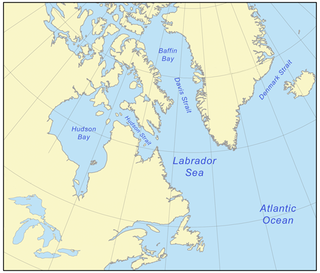
The Canadian Arctic Rift System is a major North American geological structure extending from the Labrador Sea in the southeast through Davis Strait, Baffin Bay and the Arctic Archipelago in the northwest. It consists of a series of interconnected rifts that formed during the Paleozoic, Mesozoic and Cenozoic eras. Extensional stresses along the entire length of the rift system have resulted in a variety of tectonic features, including grabens, half-grabens, basins and faults.

The geology of New Caledonia includes all major rock types, which here range in age from ~290 million years old (Ma) to recent. Their formation is driven by alternate plate collisions and rifting. The mantle-derived Eocene Peridotite Nappe is the most significant and widespread unit. The igneous unit consists of ore-rich ultramafic rocks thrust onto the main island. Mining of valuable metals from this unit has been an economical pillar of New Caledonia for more than a century.


