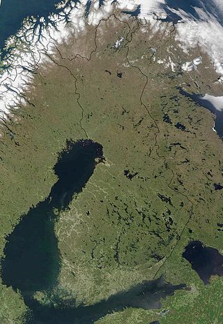
The geography of Finland is characterized by its northern position, its ubiquitous landscapes of intermingled boreal forests and lakes, and its low population density. Finland can be divided into three areas: archipelagoes and coastal lowlands, a slightly higher central lake plateau and uplands to north and northeast. Bordering the Baltic Sea, Gulf of Bothnia, and Gulf of Finland, as well as Sweden to the west, Norway to the north, and Russia to the east, Finland is the northernmost country in the European Union. Most of the population and agricultural resources are concentrated in the south. Northern and eastern Finland are sparsely populated containing vast wilderness areas. Taiga forest is the dominant vegetation type.

The demographics of Finland is monitored by the Statistics Finland. Finland has a population of over 5.6 million people, ranking it 19th out of 27 within the European Union. The average population density in Finland is 19 inhabitants per square kilometre (49/sq mi), making it the third most sparsely populated country in Europe, after Iceland and Norway. Population distribution is extremely uneven, with the majority of the population concentrated in the southern and western regions of the country. The majority of the Finnish population - approximately 73% - lives in urban areas. Approximately 1.6 million, or almost 30%, reside solely in the Helsinki Metropolitan Area. Conversely, the Arctic Lapland region contains only two inhabitants per square kilometre (5.2/sq mi).
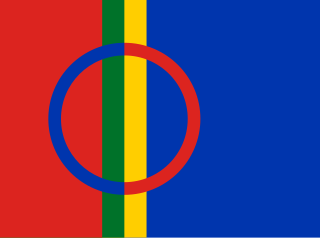
Sápmi is the cultural region traditionally inhabited by the Sámi people. Sápmi includes the northern parts of Fennoscandia, also known as the "Cap of the North".
Norrbotten County is the northernmost county or län of Sweden. It is also the largest county by land area, almost a quarter of Sweden's total area. It shares borders with Västerbotten County to the southwest, the Gulf of Bothnia to the southeast, the counties of Nordland and Troms in Norway to the northwest, and Lapland Province in Finland to the northeast.

Rovaniemi is a city in Finland and the regional capital of Lapland. It is located near the Arctic Circle in the northern interior of the country. The population of Rovaniemi is approximately 66,000, while the sub-region has a population of approximately 69,000. It is the 17th most populous municipality in Finland, and the 12th most populous urban area in the country. Rovaniemi is also the largest city in Europe by land area.

Västerbotten, sometimes called West Bothnia or Westrobothnia, is a province (landskap) in northern Sweden, located by the Gulf of Bothnia. It borders the provinces of Ångermanland, Lapland and Norrbotten. The region is famous for Västerbotten cheese.
Between 1634 and 2009, Finland was administered as several provinces. Finland had always been a unitary state: the provincial authorities were part of the central government's executive branch and apart from Åland, the provinces had little autonomy. There were never any elected provincial parliaments in continental Finland. The system was initially created in 1634. Its makeup was changed drastically on 1 September 1997, when the number of the provinces was reduced from twelve to six. This effectively made them purely administrative units, as linguistic and cultural boundaries no longer followed the borders of the provinces. The provinces were eventually abolished at the end of 2009. Consequently, different ministries may subdivide their areal organization differently. Besides the former provinces, the municipalities of Finland form the fundamental subdivisions of the country. In current use are the regions of Finland, a smaller subdivision where some pre-1997 läänis are split into multiple regions. Åland retains its special autonomous status and its own regional parliament.

Lapland is the largest and northernmost region of Finland. The 21 municipalities in the region cooperate in a Regional Council. Lapland borders the Finnish region of North Ostrobothnia in the south. It also borders the Gulf of Bothnia, Norrbotten County in Sweden, Finnmark County and Troms County in Norway, and Murmansk Oblast and the Republic of Karelia in Russia. The topography of Lapland varies from vast mires and forests in the south to fells in the north. The Arctic Circle crosses Lapland, so polar phenomena such as the midnight sun and polar night can be viewed in this region.

Kemi is a town and municipality of Finland. It is located very near the city of Tornio and the Swedish border. The distance to Oulu is 105 kilometres (65 mi) to the south and to Rovaniemi is 117 kilometres (73 mi) to the northeast. It was founded in 1869 by a decree of the Emperor Alexander II of Russia because of its proximity to a deepwater port.

Inari is Finland's largest municipality by area, with four official languages, more than any other in the country. Its major sources of income are tourism, service industry, and cold climate testing. With the Siida museum in the village of Inari, it is a center of Sámi culture, widely known as the "capital of Sámi culture".

Muonio is a municipality of Finland. The town is located in fell-region of far northern Finland above the Arctic Circle on the country's western border with Sweden, the Muonio River. It lies within the area of the former Lappi (Lapland) province in the Fell Lapland subregion. The next closest Finnish municipalities are Enontekiö to the north, Kittilä on the east, and Kolari to the south. Southwest of the town, a road bridge crosses the Muonio River, across the river, in Sweden, lies the nearby hamlet of Muoniovaara in northern Pajala Municipality in Norrbotten County.
Sodankylä is a municipality of Finland. It is located in the region of Lapland, and lies at the northern end of Highway 5 (E63) and along Highway 4 (E75). The Kitinen River flows near the center of Sodankylä. Its neighbouring municipalities are Inari, Kemijärvi, Kittilä, Pelkosenniemi, Rovaniemi, and Savukoski. The municipality has two official languages: Finnish and Northern Sami.

Lapland, also known by its Swedish name Lappland, is a province in northernmost Sweden. It borders the Swedish provinces of Jämtland, Ångermanland, Västerbotten, and Norrbotten, as well as Norway and Finland. Nearly a quarter of Sweden's land area is in Lappland.

Haplogroup N (M231) is a Y-chromosome DNA haplogroup defined by the presence of the single-nucleotide polymorphism (SNP) marker M231.

Suomenselkä is a drainage divide in western Finland. Roughly 500 kilometres (310 mi) long and 30–50 kilometres (19–31 mi) wide, it is marked by an ensemble of northeast–southwest oriented moraines parallel to the Bothnian coastline. Rivers flowing west from Suomenselkä drain to the Gulf of Bothnia and the lakes in the east drain to the Gulf of Finland. Geographically, the area is relatively flat, with highest altitude variations being 20 m. Because of the low relief, there are bifurcation lakes. Historically, this very sparsely populated region separated Ostrobothnia from the southern and eastern lake regions of Finland. The landscape is marked by moraines, eskers, bogss and forests and is difficult to cultivate or settle in. Most of the forests are pine barrens, where the main species is Scots pine. Large bogs are common. Because it contains some of the few remaining patches of old-growth forest in southern Finland, it is one of the few remaining habitats for Finnish Forest Reindeer. Suomenselkä is often called Lapin sormi, because it extends Lapland's high snowfall and poor plant growth far south into Finland.

During World War II, the Lapland War saw fighting between Finland and Nazi Germany – effectively from September to November 1944 – in Finland's northernmost region, Lapland. Though the Finns and the Germans had been fighting together against the Soviet Union since 1941 during the Continuation War (1941–1944), peace negotiations between the Finnish government and the Allies of World War II had been conducted intermittently during 1943–1944, but no agreement had been reached. The Moscow Armistice, signed on 19 September 1944, demanded that Finland break diplomatic ties with Germany and expel or disarm any German soldiers remaining in Finland.

Kemi-Tornio sub-region is a subdivision of Finnish Lapland and, since 2009, one of the sub-regions of Finland.

Northern Lapland is a subdivision of Finnish Lapland and one of the sub-regions of Finland since 2009. It is the largest and most sparsely populated sub-region in Finland.

Fell Lapland is a subdivision of Finnish Lapland, and one of the sub-regions of Finland since 2009.

Koillismaa is a subdivision of Northern Ostrobothnia and one of the sub-regions of Finland since 2009.


