Eaton Footbridge | |
---|---|
Coordinates | 51°41′08″N1°38′40″W / 51.685531°N 1.644331°W Coordinates: 51°41′08″N1°38′40″W / 51.685531°N 1.644331°W |
Carries | Footpath |
Crosses | River Thames |
Locale | Oxfordshire |
Characteristics | |
Material | Wood |
Height | 9 ft 9 in (2.97 m) |
History | |
Opened | 1936 |
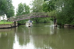
Eaton Footbridge is a wooden footbridge across the River Thames in Oxfordshire, England. It is situated on the reach above Grafton Lock.
The bridge was built in 1936 on the site of the last flash lock on the river which was in a weir known as Hart's Weir. The weir and lock, the last remaining on the Thames, were removed that year leaving the mooring cuts which are still in use. There was a lock keeper at the weir and a walkway across which is the precedent for the current bridge. The flash lock was notoriously difficult and Thacker quoted Henry Taunt: "I recollect one winter in passing this very weir, when lying on my back in the boat to get through, scraping a fair amount of skin off my nose and face though contact with the bridge whilst going under it." [1]
The English River Thames is navigable from Cricklade or Lechlade to the sea, and this part of the river falls 71 meters (234 feet). There are 45 locks on the river, each with one or more adjacent weirs. These lock and weir combinations are used for controlling the flow of water down the river, most notably when there is a risk of flooding, and provide for navigation above the tideway.
Teddington Lock is a complex of three locks and a weir on the River Thames in England between Ham and Teddington in the London Borough of Richmond upon Thames. It was first built in 1810.
Caversham Lock is a lock and main weir on the River Thames in England at Reading, Berkshire. Both the lock and main weir are connected to De Bohun Island. The Thames Navigation Commissioners built the original lock in 1778. Additional sluices north of View Island and Heron Island form the whole weir complex. A footbridge passes over all three islands to connect Lower Caversham to Reading via a route other than George Street and Reading Bridge.
Mapledurham Lock is a lock and weir situated on the River Thames in England. The lock was first built in 1777 by the Thames Navigation Commissioners and the present lock dates from 1908.
Cookham Lock is a lock with weirs situated on the River Thames near Cookham, Berkshire, about a half-mile downstream of Cookham Bridge. The lock is set in a lock cut which is one of four streams here and it is surrounded by woods. On one side is Sashes Island and on the other is Mill Island connected to Formosa Island, the largest on the non-tidal Thames.
The Thames Path is a National Trail following the River Thames from its source near Kemble in Gloucestershire to the Thames Barrier at Charlton, south east London. It is about 184 miles (296 km) long. A path was first proposed in 1948 but it only opened in 1996.
Folly Bridge is a stone bridge over the River Thames carrying the Abingdon Road south from the centre of Oxford, England. It was erected in 1825–27, to designs of a little-known architect, Ebenezer Perry, who practised in London.
Benson Lock is a lock on the River Thames in England, close to Benson, Oxfordshire but on the opposite bank of the river. The first pound lock here was built by the Thames Navigation Commission in 1788 and it was replaced by the present masonry lock in 1870. The distance between Benson Lock and Cleeve Lock downstream is 6.5 miles (10.4 km) - the longest distance between locks on the River Thames.
Temple Lock is a lock and weir situated on the Buckinghamshire bank of the River Thames near Temple Mill Island opposite Temple Meadows and not far from Hurley, Berkshire. It was first built by the Thames Navigation Commissioners in 1773.
Boveney Lock is a lock on the River Thames situated on the Buckinghamshire bank opposite the Windsor Racecourse and close to Eton Wick. Boveney is a village a little way upstream on the same side. The lock was first built in 1838 by the Thames Navigation Commission. The lock was rebuilt in 1898 closer to the Buckinghamshire bank, and a set of boat rollers were installed on the old site.
Osney Lock is a lock on the River Thames in Oxford, England, where the village or island of Osney is next to the river.
Eynsham Lock is a lock on the River Thames in England. It is on the southern bank near Swinford Oxfordshire. The large village of Eynsham is a little distance away on the northern bank.
Shifford Lock is a lock on the River Thames in England. It is in the centre of a triangle formed by the small villages of Shifford, Duxford and Chimney in Oxfordshire. It is at the start of a navigation cut built with the lock by the Thames Conservancy in 1898. This was the only new lock built on the non-tidal Thames in the era of falling revenue after the Thames Conservancy took over responsibilities of the Thames Navigation Commission. It replaced a flash lock in a weir about 3/4 mile downstream.
Grafton Lock is a lock on the River Thames in Oxfordshire, England. It is on the northern bank between Kelmscott and Radcot, about 1 mile (1.6 km) south of the hamlet of Grafton. The lock was built by the Thames Conservancy in 1896.
Buscot Lock is a lock on the River Thames in England, near the village of Buscot, Oxfordshire.
Tenfoot Bridge is a wooden footbridge across the River Thames in Oxfordshire, England. It is situated on the reach above Shifford Lock and was built in 1869. It connects Buckland on the south bank to Chimney on the north.
Sunbury Lock Ait is the ait (island) in the River Thames in England adjacent to Sunbury Lock between Walton-on-Thames, and Sunbury-on-Thames, Surrey. It is unpopulated, but accessible by a footbridge over the lock cut from a wide section of the Thames Path towpath on the southern bank as well as walkways on the lock gates. Thirdly, a walkway links to Wheatley's Ait upstream, across the weir, but this is closed to the public. The quite long, thin island is inaccessible from Sunbury-on-Thames where it faces a long section of public riverbank, a few private conservation area Victorian terraces with moorings and two pubs also with moorings.
Hart's Weir Footbridge is a single-span concrete footbridge across the River Thames in Oxfordshire, England. Locally, it is also known as Rainbow Bridge, due to its rainbow-arc appearance as seen from the horizon. It is situated on the reach above Northmoor Lock, the nearest village being Appleton, Oxfordshire to the east.
Old Man's Bridge is a wooden footbridge across the River Thames in Oxfordshire, England. It is situated on the reach above Rushey Lock, a short way downstream of Radcot Lock.
Bloomers Hole Footbridge is a footbridge across the River Thames in Oxfordshire, England. It is situated on the reach above Buscot Lock and was installed in 2000 to carry the Thames Path across the Thames. It is built of steel encased in wood to make it look like a timber structure.
Next crossing upstream | River Thames | Next crossing downstream |
Buscot Lock (pedestrian) | Eaton Footbridge | Radcot Bridge (road) |
This Oxfordshire location article is a stub. You can help Wikipedia by expanding it. |