South Hetton is a former mining village in the County Durham district of the ceremonial county of County Durham, England. It is situated 6.25 miles (10.06 km) to the east of Durham and 7.31 miles (11.76 km) to the south of Sunderland as the crow flies. It had a population of 2,618 according to the 2001 Census, rising to 3,032 at the 2011 Census, with the latest estimate being 3,036 in 2019

Belmont is a suburb in Greater Newcastle, New South Wales, Australia, located 20 kilometres (12 mi) from Newcastle's central business district on the eastern side of Lake Macquarie and is part of the City of Lake Macquarie council.

The Belmont railway line is an abandoned coal haulage and passenger rail line from Adamstown, New South Wales to Belmont, New South Wales. This was a private railway, being the property of the New Redhead Estate and Coal Company and was generally known as the Belmont Branch. The line closed in December 1991. It has since been converted into a cycleway or rail trail - The Fernleigh Track.
Speers Point is a suburb of Greater Newcastle, and the location of the council seat of the City of Lake Macquarie local government area in New South Wales, Australia. It is 17 kilometres (10.6 mi) west-southwest of the city of Newcastle on the northern shore of Lake Macquarie, in Cockle and Warners Bays, between the suburbs of Cardiff and Warners Bay.
James Brunton Simpson was a Scottish-Australian trade unionist, coal miner and politician, elected as a member of the New South Wales Legislative Assembly for Lake Macquarie for the NSW Branch of the Labor Party.
Lancelot Edward Threlkeld was an English missionary, primarily based in Australia. He was married twice and survived by sons and daughters from both marriages. His work in Australia did much to increase knowledge of Aboriginal languages, but he had little success with converting Aborigines to Christianity.
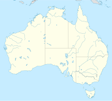
The South Maitland coalfields was the most extensive coalfield in New South Wales until the great coal mining slump of the 1960s. It was discovered by Lieutenant-Colonel Paterson's party when they were engaged in an exploratory visit to the Hunter River Valley during July 1801.
Wyee is a small town in the Lake Macquarie region of New South Wales, Australia, in the City of Lake Macquarie. It is near the Sydney-Newcastle Freeway and has a railway station on NSW TrainLink's Central Coast & Newcastle Line. It had a population of 1,487 in 2001, which significantly increased to 2,588 in 2011, and decreased to 2,406 in 2016. Wyee is considered a shanty town and remains highly unchanged since World War II.
Fassifern is a suburb of the City of Lake Macquarie, Greater Newcastle in New South Wales, Australia, located west of Lake Macquarie. The Sydney-Newcastle railway line runs through Fassifern railway station, which is a major station along the line. There used to be a branch line between Fassifern Station and nearby Toronto, but this has been replaced by a bus service, aptly named "The Train".
Coal Point is a suburb of the City of Lake Macquarie in New South Wales, Australia on a peninsula south-east of the towns of Toronto and Carey Bay, on the western side of Lake Macquarie.
Killingworth is a small town located south of West Wallsend, New South Wales and east of the Sydney-Newcastle Freeway. It is part of the West Ward of the City of Lake Macquarie local government area in Greater Newcastle.
West Wallsend is a suburb and small town in the City of Lake Macquarie, Greater Newcastle in New South Wales, Australia. It is near the Sydney-Newcastle Freeway and the western suburbs of Newcastle.
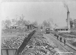
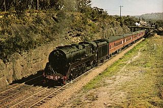
The South Maitland Railway was once an extensive network of privately owned colliery and passenger railway lines which served the South Maitland coalfields in the Hunter Region of New South Wales, Australia and were the second last system in Australia to use steam haulage, having used steam locomotives until 1983.
The South Waratah Colliery was a coal mine located at Charlestown, in New South Wales Australia.
Victoria Mines is a community in the Canadian province of Nova Scotia, located in the Cape Breton Regional Municipality on Cape Breton Island.
Archaeological evidence indicates that human beings have inhabited the area around Newcastle, New South Wales for at least 6500 years. In 2009, archaeologist uncovered over 5,534 Aboriginal artefacts, representing three occupation periods. In the 1820s, the Reverend Lancelot Threlkeld worked with local Awabakal man Biraban to record the Awabakal language. Since 1892, the Indigenous people of Newcastle have come to be known as the Awabakal.
Myuna Colliery is a coal mine at Wangi Wangi, New South Wales, Australia. The colliery was developed to provide coal for the Eraring Power Station, 5 kilometres to the west. The mine started in August 1979, with coal production commencing in 1982. The Wallarah, Great Northern and Fassifern coal seams have been mined using bord and pillar mining methods. Coal is transported to the Eraring Power Station by an overland conveyor system.
The Coastal coal-carrying trade of New South Wales involved the shipping of coal—mainly for local consumption but also for export or coal bunkering—by sea to Sydney from the northern and southern coal fields of New South Wales. It took place in the 19th and 20th centuries. It should not be confused with the export coal trade, which still exists today. There was also an interstate trade, carrying coal and coke to other Australian states that did not have local sources of black coal.

Sixty-miler (60-miler) is the colloquial name for the ships that were used in the coastal coal trade of New South Wales, Australia. The sixty-milers delivered coal to Sydney Harbour from ports and ocean jetties to the north and south of Sydney. The name refers to the approximate distance by sea from the Hunter River to Sydney.