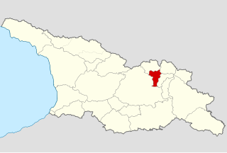
Java is a town of approximately 1,500 people in Georgia. According to Georgia's current official administrative division, Java is a main town of Java district in the north of Shida Kartli region. According to the South Ossetian side Dzau is an administrative center of Dzau district. The town is situated on the southern slopes of the Greater Caucasus, within the Greater Liakhvi Gorge, 1,040 m (3,412 ft) above sea level.

Gergeti Trinity Church is a popular name for Holy Trinity Church near the village of Gergeti in Georgia. The church is situated on the right bank of the river Chkheri, at an elevation of 2170 meters, under Mount Kazbegi.

Lentekhi is a small town and Lentekhi District's (Raion) capital in Georgia's western region of Racha-Lechkhumi and Kvemo Svaneti, 323 km northwest to the nation's capital Tbilisi. Situated on the southern slope of the Central Caucasus, the district is a site of alpinism.

Greater Caucasus is the major mountain range of the Caucasus Mountains.

Pshavi is a small historic region of northern Georgia, nowadays part of the Mtskheta-Mtianeti mkhare, ("region"), and lying chiefly among the southern foothills of the Greater Caucasus mountains along the Pshavis Aragvi River and the upper reaches of the Iori River in the neighbouring region of Tianeti to the south-east.

Mtskheta-Mtianeti is a region (Mkhare) in eastern Georgia comprising the town of Mtskheta, which serves as a regional capital, together with its district and the adjoining mountainous areas. The western part is controlled by the breakaway Republic of South Ossetia since 1992 and the independence of Georgia.

Khevi is a small historical-geographic area in northeastern Georgia. It is included in the modern-day Kazbegi district, Mtskheta-Mtianeti region (mkhare). Located on the northern slopes of the Greater Caucasus mountains, it comprises three gorges of the rivers Truso, Tergi (Terek) and Snostsq’ali.

Ksani is a small river in central Georgia, which rises on the southern slopes of the Greater Caucasus Mountain Range in South Ossetia and flows into the Kura River. Ksani is often associated with the Medieval Georgian Ksani Fortress which lies close to the Ksani River.

The Aragvi River and its basin are in Georgia on the southern slopes of the Caucasus Mountains. The river is 112 kilometres (70 mi) long, and its basin covers an area of 2,724 square kilometres (1,052 sq mi). The ground strata are mostly sandstone, slate, and limestone. The Zhinvali Dam and its 130 MW hydro-electric power station generate much of Georgia’s power, and its construction in 1986 formed the Zhinvali Reservoir, upon whose north-western shores rises Ananuri castle with its 17th-century Church of the Assumption.

The Mikheil Meskhi Stadium, also known as the Lokomotivi Stadium, is a multi-purpose stadium in Tbilisi, Georgia named after the famous Georgian international footballer, Mikheil Meskhi. It is used mostly for football matches, and occasionally for rugby union and rugby league matches. The stadium was renovated in 2001 and has a capacity to hold 27,223 people. It is the second largest stadium in Georgia, after the Boris Paichadze Stadium.
Mtiuleti is a historical province in eastern Georgia, on the southern slopes of the Greater Caucasus Mountains. It primarily comprises the White Aragvi Valley, and is bordered by Gudamakari on the east, Khando on the south, Tskhrazma on the west, and Khevi on the north. Mtiuleti occupies parts of modern-day districts of Dusheti and Kazbegi, Mtskheta-Mtianeti region (mkhare). A townlet (daba) Pasanauri, famous for its khinkali, is a traditional center of the region.

Samtavisi is an eleventh-century Georgian Orthodox cathedral in eastern Georgia, in the region of Shida Kartli, some 45km from the nation’s capital Tbilisi. The cathedral is now one of the centers of the Eparchy of Samtavisi and Gori of the Georgian Orthodox Church.
The Ikorta church of the Archangel, commonly known as Ikorta (იკორთა) is a 12th-century Georgian Orthodox church located at the outskirts of the village Ikort’a in Shida Kartli region of eastern Georgia.

Edişə is a village and municipality in the Jalilabad Rayon of Azerbaijan. It has a population of 710.

Martvili is a district of Georgia, in the region of Samegrelo-Zemo Svaneti. Its main town is Martvili.

Dusheti is a municipality of Georgia, in the region of Mtskheta-Mtianeti. Its main town is Dusheti.

Tianeti is a municipality of Georgia, in the region of Mtskheta-Mtianeti. Its main town is Tianeti.

Kazbegi is a district of Georgia, in the region of Mtskheta-Mtianeti. According to the 2014 Census a population of the district compose 3,795 inhabitants. Area of the district is 1,081.7 km². The main settlement is Stepantsminda, accounting for about half of the total population.
Bedia is a village in the Gali Municipality of Georgia.

42.835089°N 44.9368863°E