
The Krishna River is a river in the Deccan plateau and is the third-longest river in India, after the Ganges and Godavari. It is also the fourth-largest in terms of water inflows and river basin area in India, after the Ganges, Indus and Godavari. The river, also called Krishnaveni, is 1,400 kilometres (870 mi) long and its length in Maharashtra is 282 kilometres. It is a major source of irrigation in the Indian states of Maharashtra, Karnataka, Telangana and Andhra Pradesh.

Thrissur, formerly Trichur, also known by its historical name Thrissivaperur, is a city and the headquarters of the Thrissur district in Kerala, India. It is the third largest urban agglomeration in Kerala after Kochi and Kozhikode, and the 21st largest in India. The city is built around a 65-acre (26 ha) hillock called the Thekkinkaadu Maidaanam which seats a large Hindu Shiva Temple. It is located 304 kilometres (189 mi) north-west of the state's capital city, Thiruvananthapuram. Thrissur was once the capital of the Kingdom of Cochin, and was a point of contact for the Assyrians, Greeks, Persians, Arabs, Romans, Portuguese, Dutch and English.

Krishna district is a district in the coastal Andhra Region in Indian state of Andhra Pradesh, with Machilipatnam as its administrative headquarters. It is surrounded on the East by Bay of Bengal, West by Guntur, Bapatla and North by Eluru and NTR districts and South again by Bay of Bengal.

The Buckingham Canal is a 796 kilometres (494.6 mi)-long fresh water navigation canal, that parallels the Coromandel Coast of South India from Kakinada City in the Kakinada district of Andhra Pradesh to Village near Chidambaram, Cuddalore District of Tamil Nadu, India. The canal connects most of the natural backwaters along the coast to Chennai (Madras) port.
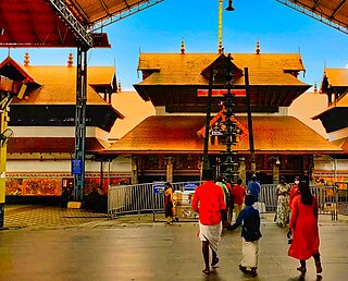
GuruvayurIPA:[guɾuʋɐːjuːr]) is a municipal temple town in Thrissur district, of Kerala State in India. It is a suburban town of Thrissur city, located 27 kilometres (17 mi) from Thrissur towards the north-west. It houses the Guruvayur Shri Krishna Temple. It is located at a distance of 292 km (181 mi) from the state capital Trivandrum towards the north-west, 80 km (50 mi) from Kochi towards the north, 90 km (56 mi) from Calicut towards south.

Pulicat Lake is the second largest brackish water lagoon in India,, measuring 759 square kilometres (293 sq mi). A major part of the lagoon lies in the Tirupati district of Andhra Pradesh. The lagoon is one of three important wetlands that attracts northeast monsoon rain clouds during the October to December season. The lagoon comprises the following regions: Pulicat Lake, Marshy/Wetland Land Region (AP), Venadu Reserve Forest (AP), and Pernadu Reserve Forest (AP). The lagoon was cut across in the middle by the Sriharikota Link Road, which divided the water body into lagoon and marshy land. The lagoon encompasses the Pulicat Lake Bird Sanctuary. The barrier island of Sriharikota separates the lagoon from the Bay of Bengal and is home to the Indian Space Research Organisation's Satish Dhawan Space Centre.
Hamsaladeevi is a village in Diviseema, Koduru Mandal, Krishna District of the Indian state of Andhra Pradesh.
Tenali is a city in Guntur district of the Indian state of Andhra Pradesh. It is a municipality, and the headquarters of Tenali mandal and Tenali revenue division. The city is renowned for art, culture, drama, and hence, it is called Andhra Paris. It is one of the twelve urban local bodies in Andhra Pradesh Capital Region and the twelfth most populous town in the state, with a population of 199,345 as of 2011. Tenali town is also part of Andhra Pradesh Capital Region Development Authority (APCRDA).

Udupi district is an administrative subdivision in the Karnataka state of India, with the district headquarters in the city of Udupi. It is situated in the Canara old north malabar coastal region, there are seven taluks, 233 villages and 21 towns in Udupi district. The three northern tehsils of Udupi, Kundapur and Karkala, were partitioned from Dakshina Kannada district to form Udupi district on 25 August 1997. Moodabidri was officially declared as new tehsil (taluk), separated from Karkala with effect from 11 January 2018.

Nagarjuna Sagar Dam is a masonry dam across the Krishna River at Nagarjuna Sagar which straddles the border between Palnadu district in Andhra Pradesh and Nalgonda district in Telangana. The dam provides irrigation water to the districts of Palnadu, Guntur, Nalgonda, Prakasam, Khammam, Krishna, and parts of West Godavari. It is also a source of electricity generation for the national grid.

Nuzvid, natively spelled Nuzividu or Nuziveedu is a city in the Eluru district of the Indian state of Andhra Pradesh. It serves as the administrative headquarters for Nuzvid mandal and Nuzvid revenue division.
Vandalur is a census town and taluk headquarters in the Chengalpattu district lying south of the metropolitan city of Chennai, India. Vandalur serves as the southern gateway to Chennai city. It has the Arignar Anna Zoological Park, which contain some rare species of wild flora and fauna. The town is served by Vandalur railway station of the Chennai Suburban Railway network.
Avanigadda is a town in Krishna district of the Indian state of Andhra Pradesh. It is the mandal headquarters of Avanigadda mandal in Machilipatnam revenue division.

The 2008 North Indian cyclone season was one of the most disastrous tropical cyclone seasons in modern history, causing more than 140,000 fatalities and over US$15 billion in damage. At the time, it was the costliest season in the North Indian Ocean, until it was surpassed by 2020. The season has no official bounds but cyclones tend to form between April and December. These dates conventionally delimit the period of each year when most tropical cyclones form in the northern Indian Ocean. There are two main seas in the North Indian Ocean—the Bay of Bengal, which is east of India, and the Arabian Sea, which is west of India. The official Regional Specialized Meteorological Centre in this basin is the India Meteorological Department (IMD), however the Joint Typhoon Warning Center releases unofficial advisories for military interests. An average of four to six storms form in the North Indian Ocean every season. Cyclones occurring between the meridians 45°E and 100°E are included in the season by the IMD.

P. K. Raghava Warrier FRCS was a cardiothoracic surgeon, author and social activist from Kerala, India.
Gundwad is a village in Belgaum district in the southern state of Karnataka, India. situated on the bank of Krishna River. There is a Parshvanatha Basadi in the village which can be seen from few kilometres.

The 2015 South India floods resulted from heavy rainfall generated by the annual northeast monsoon in November–December 2015. They affected the Coromandel Coast region of the South Indian states of Tamil Nadu and Andhra Pradesh. More than 500 people were killed and over 1.8 million people were displaced. With estimates of damages and losses ranging from nearly ₹200 billion (US$3 billion) to over ₹1 trillion (US$13 billion), the floods were the costliest to have occurred in 2015, and were among the costliest natural disasters of the year.
Avanigadda mandal is one of the 25 mandals in Krishna district of the Indian state of Andhra Pradesh. It is under the administration of Machilipatnam revenue division and the headquarters are located at Avanigadda. The mandal is bounded by Mopidevi, Koduru and Nagayalanka mandals.
Challapalli mandal is one of the 25 mandals in the Krishna district of the Indian state of Andhra Pradesh. The headquarters of this mandal are located in Challapalli.


