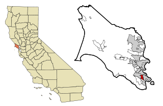
Marin County is a county located in the northwestern part of the San Francisco Bay Area of the U.S. state of California. As of the 2020 census, the population was 262,231. Its county seat and largest city is San Rafael. Marin County is across the Golden Gate Bridge from San Francisco, and is included in the San Francisco–Oakland–Berkeley, CA Metropolitan Statistical Area.

San Anselmo is an incorporated town in Marin County, California, United States. San Anselmo is located 1.5 miles (2.4 km) west of San Rafael, at an elevation of 46 feet (14 m). It is located about 20 miles (32 km) north of San Francisco. The town is bordered by San Rafael to the east, Fairfax to the west, and Ross to the south. Mount Tamalpais dominates the view to the south. The population was 12,830 at the 2020 census.

Bolinas is an unincorporated coastal community and census-designated place in Marin County, California, United States. As of the 2020 census it had a population of 1,483. It is located on the California coast, approximately 13 miles (21 km) northwest of San Francisco, and 27 miles (43 km) by road.

Kentfield is a census-designated place (CDP) in Marin County, California, United States, just north of San Francisco. Kentfield is located 2 miles (3 km) southwest of downtown San Rafael, at an elevation of 115 feet. The population was 6,808 at the 2020 census. The ZIP codes are 94904 for street addresses, and 94914 for PO boxes, and are shared with the neighboring community of Greenbrae.

Mill Valley is a city in Marin County, California, United States, located about 14 miles (23 km) north of San Francisco via the Golden Gate Bridge and 52 miles (84 km) from Napa Valley. The population was 14,231 at the 2020 census.

Stinson Beach is an unincorporated community and census-designated place (CDP) in Marin County, California, on the west coast of the United States. Stinson Beach is located east-southeast of Bolinas, right across the channel that terminates the bay mouth bar of the Bolinas Lagoon. at an elevation of 26 feet (8 m). The population of the Stinson Beach CDP was 541 at the 2020 census.
Strawberry is a census-designated place (CDP) and an unincorporated district of Marin County, California, United States. It shares a ZIP code (94941) with Mill Valley and falls within its school districts; however, it is considered within the sphere of influence of the town of Tiburon. It is largely separated from Mill Valley by U.S. Route 101. Its population was 5,447 at the 2020 census.

Area codes 415 and 628 are telephone area codes in the North American Numbering Plan (NANP) for the city of San Francisco and its northern suburbs in Marin County, and the northeast corner of San Mateo County in the U.S. state of California. Area code 415 was one of the eighty-six original North American area codes established in 1947, but modified in geographic configuration later. Area code 628 was assigned in 2015 to form an overlay in that numbering plan area in mitigation of central office prefix exhaustion.

Mount Tamalpais, known locally as Mount Tam, is a peak in Marin County, California, United States, often considered symbolic of Marin County. Much of Mount Tamalpais is protected within public lands such as Mount Tamalpais State Park, the Marin Municipal Water District watershed, and National Park Service land, such as Muir Woods.

Tamalpais High School is a public secondary school located in Mill Valley, California, in the San Francisco Bay Area. It is named after nearby Mount Tamalpais, which rises almost 2,500 feet (760 m) above Mill Valley.

The Marin Hills are a series of steep high ridges and peaks in southern Marin County. They are a part of the long Pacific Coast Ranges mountain system. The centerpoint of these hills is the 2,571 foot Mount Tamalpais near Mill Valley. The hills are bordered to the north by the Santa Rosa Plain and Laguna de Santa Rosa; to the east by the San Pablo Bay, the northern arm of San Francisco Bay; to the south by the Golden Gate Strait; and to the west by the San Andreas Fault, running through Tomales Bay, Olema Valley, Bolinas Lagoon, and Stinson Beach. Parts of the hills are protected for their scenic beauty by Mount Tamalpais State Park and the Golden Gate National Recreation Area. The many ridges and peaks of these hills form a dramatic backdrop to the Golden Gate Bridge, the San Francisco skyline, and several towns around Richardson Bay when viewed from the south.

The Tamalpais Union High School District or TUHSD provides high school education to students residing in ten elementary districts in central and southern Marin County, California and parts of West Marin. The headquarters are on the property of Redwood High School in Larkspur, California.

Lagunitas is an unincorporated community in Marin County, California. It is located 10 miles (16 km) southwest of Novato, at an elevation of 217 feet. Lagunitas is aggregated with Forest Knolls by the U.S. Census into the census-designated place (CDP) Lagunitas-Forest Knolls.
The Mill Valley School District is located 13 miles north of San Francisco and the Golden Gate Bridge in Marin County, California. The district has 5 elementary schools and 1 middle school with an enrollment of approximately 3,200 students in grades K through 8. Four of the schools are located within the City of Mill Valley, while two are located in the adjacent unincorporated areas of Strawberry and Tamalpais Valley.

Dogtown is an unincorporated community in the rural West Marin region of coastal Marin County, California in the San Francisco Bay Area's North Bay. It lies at an elevation of 187 feet. With a population of 30, the town is located beside the Golden Gate National Recreation Area and Point Reyes National Seashore, in the Olema Valley west of the Bolinas Ridge mountain range.

Bolinas Ridge is a north-south ridge in southwestern Marin County, California. Much of the western side of the ridge is protected parkland in the Golden Gate National Recreation Area, and the eastern side is watershed lands of the Marin Municipal Water District.
The Novato Unified School District is a school district in Novato, California.
The Lagunitas School District is a public K–8 school district located 18 miles northwest of San Francisco in western-central Marin County, California. The district serves students in the unincorporated San Geronimo Valley.
Ross Valley School District (RVSD) is a public TK-8 school district located 13 miles north of San Francisco, on the north side of Mount Tamalpais, in Marin County, California.