The Usarp Mountains is a major Antarctic mountain range, lying westward of the Rennick Glacier and trending N-S for about 190 kilometres (118 mi). The feature is bounded to the north by Pryor Glacier and the Wilson Hills. Its important constituent parts include Welcome Mountain, Mount Van der Hoeven, Mount Weihaupt, Mount Stuart, Mount Lorius, Smith Bench, Mount Roberts, Pomerantz Tableland, Daniels Range, Emlen Peaks, Helliwell Hills and Morozumi Range.

The Prince Charles Mountains are a major group of mountains in Mac. Robertson Land in Antarctica, including the Athos Range, the Porthos Range, and the Aramis Range. The highest peak is Mount Menzies. Other prominent peaks are Mount Izabelle and Mount Stinear. These mountains together with other scattered peaks form an arc about 260 miles long, extending from the vicinity of Mount Starlight in the north to Goodspeed Nunataks in the south.
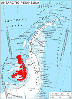
Uranus Glacier is a glacier on the east coast of Alexander Island, Antarctica, 30 kilometres long and 10 km (6 mi) wide at its mouth, flowing east into George VI Sound immediately south of Fossil Bluff. Along the south face of the glacier is an east–west escarpment called Kuiper Scarp.
Iapetus Nunatak is an isolated nunatak at the southwest margin of Satellite Snowfield, about midway between the Walton Mountains and the Staccato Peaks in southern Alexander Island, Antarctica. It was mapped by the Directorate of Overseas Surveys from satellite imagery supplied by the U.S. National Aeronautics and Space Administration in cooperation with the U.S. Geological Survey, and was named by the UK Antarctic Place-Names Committee from association with Saturn Glacier, after Iapetus, one of the satellites of Saturn.

Crane Glacier, is a narrow glacier which flows 30 miles (50 km) in an east-northeasterly direction along the northwest side of Aristotle Mountains to enter Spillane Fjord south of Devetaki Peak, on the east coast of the Antarctic Peninsula. Sir Hubert Wilkins photographed this feature from the air in 1928 and gave it the name "Crane Channel", after C.K. Crane of Los Angeles, reporting that it appeared to be a channel cutting in an east-west direction across the peninsula. The name was altered to "Crane Inlet" following explorations along the west coast of the peninsula in 1936 by the British Graham Land Expedition, which proved that no through channel from the east coast existed as indicated by Wilkins. Comparison of Wilkins' photograph of this feature with those taken in 1947 by the Falklands Islands Dependencies Survey shows that Wilkins' "Crane Channel" is this glacier, although it lies about 75 miles (120 km) northeast of the position originally reported by Wilkins.
Clifford Glacier is a broad glacier, about 40 nautical miles (70 km) long, flowing in an east-northeast direction to the gap between Mount Tenniel and the Eland Mountains, and then east to Smith Inlet on the east coast of Palmer Land. The upper part of this glacier was charted in 1936 by the British Graham Land Expedition under John Rymill; the seaward side by the United States Antarctic Service survey party which explored along this coast in 1940. During 1947 it was photographed from the air by the Ronne Antarctic Research Expedition under Finn Ronne, who in conjunction with the Falkland Islands Dependencies Survey (FIDS) charted it from the ground. It was named in 1952 by the FIDS for Sir G. Miles Clifford, at that time Governor of the Falkland Islands.

Coulter Glacier is a steeply inclined glacier, 5 nautical miles (9 km) long, flowing south from the Havre Mountains, northern Alexander Island, into Kolokita Cove in Lazarev Bay, Antarctica. The glacier was photographed from the air by the Ronne Antarctic Research Expedition in 1947 and mapped from the photographs by the Falkland Islands Dependencies Survey in 1960. It was named by the Advisory Committee on Antarctic Names for R.W. Coulter, Master of USNS Alatna during U.S. Navy Operation Deepfreeze, 1969.
Derocher Peninsula is a snow-covered peninsula between Brahms Inlet and Mendelssohn Inlet on the north side of Beethoven Peninsula, Alexander Island, Antarctica. It was photographed from the air by the Ronne Antarctic Research Expedition, 1947–48, and mapped from these photographs by D. Searle of the Falkland Islands Dependencies Survey (FIDS), 1960. It was named by the Advisory Committee on Antarctic Names after Commander Paul J. Derocher, U.S. Navy, Commanding Officer, Antarctic Development Squadron Six (VXE-6), May 1985 to May 1986. Derocher Peninsula is one of the eight peninsulas of Alexander Island.

Dewar Nunatak is a mainly snow-covered nunatak rising to 520 metres (1,700 ft) in the middle of Shambles Glacier, on the east coast of Adelaide Island. It was named by the UK Antarctic Place-Names Committee in 1963 for Graham J.A. Dewar, a British Antarctic Survey geologist at Adelaide station, 1961–63.
Gurling Glacier is a glacier draining between Krebs Ridge and Leininger Peak into the southwest corner of Smith Inlet, on the east coast of Palmer Land, Antarctica. It was named by the UK Antarctic Place-Names Committee after Paul William Gurling, a British Antarctic Survey surveyor who worked in the general vicinity of this feature. Paul was a BAS surveyor, Stonington Island.
Planet Heights is a series of summits running along an ice-free ridge, extending 24 nautical miles (44 km) in a north-south direction between the southernmost extremity of the LeMay Range and George VI Sound in the east part of Alexander Island, Antarctica. Many landforms and nearby features are named in association with this mountain range, some of these include landforms named after astronomers, satellites, planets and other things related to astrology and astrophysics. The mountain range was first mapped from air photos taken by the Ronne Antarctic Research Expedition (RARE), 1947–48, by Searle of the Falkland Islands Dependencies Survey (FIDS) in 1960. Named by the United Kingdom Antarctic Place-Names Committee (UK-APC) from association with the nearby glaciers named for planets of the solar system. The only planet that is not featured in any of these glaciers is the planet Earth, as there are no glaciers named "Earth Glacier" and this glacier does not exist.
Eros Glacier is a glacier on the east coast of Alexander Island, Antarctica, 7 nautical miles (13 km) long and 2 nautical miles (4 km) wide at its mouth, flowing southeast from the Planet Heights into George VI Sound immediately north of Fossil Bluff. It was probably first seen on November 23, 1935, by Lincoln Ellsworth, who flew directly over the glacier and obtained photos of features north and south of it. The mouth of the glacier was observed and positioned by the British Graham Land Expedition in 1936 and the Falkland Islands Dependencies Survey (FIDS) in 1948 and 1949. The glacier was mapped in detail from air photos taken by the Ronne Antarctic Research Expedition, 1947–48, by D. Searle of the FIDS in 1960. It was named by the UK Antarctic Place-Names Committee after the minor planet Eros in association with nearby Pluto Glacier and Uranus Glacier.
Gangbrekka Pass is a mountain pass between Jutulrora Mountain and Brekkerista Ridge in the Sverdrup Mountains of Queen Maud Land of Antarctica. It was mapped by Norwegian cartographers from surveys and air photos by the Norwegian–British–Swedish Antarctic Expedition (1949–52) and from air photos by the Norwegian expedition (1958–59) and named Gangbrekka.
Handel Ice Piedmont is a large ice piedmont lying north and west of the Colbert Mountains, between Haydn Inlet and Schubert Inlet on the west-central coast of Alexander Island, Antarctica. Apparently first seen from the air by the United States Antarctic Service in 1940 but not separately mapped, it was first mapped from air photos taken by the Ronne Antarctic Research Expedition, 1947–48, by Searle of the Falkland Islands Dependencies Survey in 1960. The feature was named by the UK Antarctic Place-Names Committee for George Frideric Handel, the German composer.
Hughes Ice Piedmont is the ice piedmont between Cordini Glacier and Smith Inlet on the east coast of Palmer Land, Antarctica. It was named by the Advisory Committee on Antarctic Names for Terence J. Hughes, a United States Antarctic Research Program glaciologist at Deception Island and McMurdo Sound during 1970–71, and at Deception Island, 1973–74.
McArthur Glacier is a glacier between the Christie Peaks and Swine Hill, flowing west from Palmer Land, Antarctica, into George VI Sound. It was named by the UK Antarctic Place-Names Committee for Alistair H. McArthur, a British Antarctic Survey geophysicist at Stonington Island, 1967–68.
Spartan Glacier is a short valley glacier lying between Callisto Cliffs and Tombaugh Cliffs on the east side of Alexander Island, Antarctica. The glacier was first mapped by the Overseas Surveys Directorate from satellite imagery supplied by U.S. National Aeronautics and Space Administration in cooperation with U.S. Geological Survey. Named by United Kingdom Antarctic Place-Names Committee after the British dog team known as "The Spartans," used in ascending this glacier, 1969. This is one of the few glaciers in Antarctica to be named after a dog team.
Holst Peak is a rocky pyramidal peak, rising to about 1,000 metres (3,300 ft), midway between the south end of the Walton Mountains and the LeMay Range in the central part of Alexander Island, Antarctica. It was first mapped by D. Searle of the Falkland Islands Dependencies Survey in 1960 from air photos obtained by the Ronne Antarctic Research Expedition, 1947–48, and was named by the UK Antarctic Place-Names Committee for Gustav Holst, the English composer.
Richter Peaks is a group of peaks rising to about 1,385 m located near the southern extremity of the Walton Mountains, situated in the central portion of Alexander Island, Antarctica. The peaks were named by Advisory Committee on Antarctic Names for Joseph J. Richter, United States Antarctic Research Program biologist, Palmer Station, 1965–66 and 1966-67.

Arensky Glacier is an Antarctic glacier, lying 3 miles (5 km) east of Alyabiev Glacier and flows south from Beethoven Peninsula, Alexander Island, into the north end of Boccherini Inlet. The glacier was named by the USSR Academy of Sciences in 1987, after Anton Arensky, the Russian composer.


