
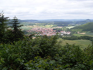
Dingelstädt is a town in the district of Eichsfeld in Thuringia, Germany. It is situated on the upper course of the river Unstrut, 8 km (5 mi) south of Leinefelde-Worbis and 15 km (9 mi) northwest of Mühlhausen. The former municipalities Helmsdorf, Kefferhausen, Kreuzebra and Silberhausen were merged into Dingelstädt in January 2019. In January 2023 Dingelstädt absorbed the villages Bickenriede and Zella from the former municipality Anrode, and Beberstedt and Hüpstedt from the former municipality Dünwald. In January 2024 it absorbed the village Struth from the former municipality Rodeberg.
Glasehausen is a village and a former municipality in the district of Eichsfeld in Thuringia, Germany. On 1 January 2024 it became part of the town Heilbad Heiligenstadt.
Hohes Kreuz is a former municipality in the Eichsfeld in Thuringia, Germany. The municipality was created in 1991 by merging the municipalities of Bischhagen, Mengelrode, Siemerode, and Streitholz. On 1 January 2024 it became part of the town Heilbad Heiligenstadt.
Birkenfelde is a village and a former municipality in the district of Eichsfeld, in Thuringia, Germany. On 1 January 2024 it became part of the municipality Uder.
Lenterode is a village and a former municipality in the district of Eichsfeld in Thuringia, Germany. On 1 January 2024 it became part of the municipality Uder.
Lutter is a village and a former municipality in the district of Eichsfeld in Thuringia, Germany. On 1 January 2024 it became part of the municipality Uder.
Mackenrode is a village and a former municipality in the district of Eichsfeld in Thuringia, Germany. On 1 January 2024 it became part of the municipality Uder.
Röhrig is a village and a former municipality in the district of Eichsfeld in Thuringia, Germany. On 1 January 2024 it became part of the municipality Uder.
Schönhagen is a village and a former municipality in the district of Eichsfeld in Thuringia, Germany. On 1 January 2024 it became part of the municipality Uder.
Thalwenden is a village and a former municipality in the district of Eichsfeld in Thuringia, Germany. On 1 January 2024 it became part of the municipality Uder.
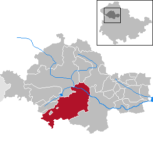
Uder is a municipality in the district of Eichsfeld in Thuringia, Germany. On 1 January 2024, the former municipality Uder was merged with the former municipalities Birkenfelde, Eichstruth, Lenterode, Lutter, Mackenrode, Röhrig, Schönhagen, Steinheuterode, Thalwenden and Wüstheuterode to form the current municipality Uder.
Wüstheuterode is a village and a former municipality in the district of Eichsfeld in Thuringia, Germany. On 1 January 2024 it became part of the municipality Uder.
Schönstedt is a village and a former municipality in the Unstrut-Hainich-Kreis district of Thuringia, Germany. On 1 January 2024 it became part of the municipality Unstrut-Hainich.

Georgenthal is a municipality in the district of Gotha, in Thuringia, Germany. The former municipalities Leinatal, Hohenkirchen and Petriroda were merged into Georgenthal in December 2019. The former municipality Herrenhof was merged into Georgenthal in January 2024.
Herrenhof is a village and a former municipality in the district of Gotha, in Thuringia, Germany. On 1 January 2024 it became part of the municipality Georgenthal.
Uder is a former Verwaltungsgemeinschaft in the district Eichsfeld, in Thuringia, Germany. The seat of the Verwaltungsgemeinschaft was in Uder. It was disbanded in January 2024, when most of its members became part of the municipality Uder.
Ländereck is a Verwaltungsgemeinschaft in the district of Greiz, in Thuringia, Germany. The seat of the Verwaltungsgemeinschaft is in Seelingstädt.
Unstrut-Hainich is a municipality in the district Unstrut-Hainich-Kreis, in Thuringia, Germany. It was created with effect from 1 January 2019 by the merger of the former municipalities of Altengottern, Flarchheim, Großengottern, Heroldishausen, Mülverstedt and Weberstedt. On 1 January 2024, it absorbed the former municipality Schönstedt. The name refers to the river Unstrut and the hill chain Hainich.

Südeichsfeld is a municipality in the Unstrut-Hainich-Kreis district, Thuringia, Germany. It was formed by the merger of the previously independent municipalities Heyerode, Katharinenberg, Hildebrandshausen and Lengenfeld unterm Stein, on 1 December 2011. On 1 January 2024, it absorbed the former municipality Hallungen.

Amt Creuzburg is a town in the Wartburgkreis district, in Thuringia, Germany. It was created with effect from 31 December 2019 by the merger of the former municipalities of Creuzburg, Ebenshausen and Mihla. On 1 January 2024, it absorbed the former municipality Frankenroda. It takes its name from the town Creuzburg, the centre of the new municipality.


