
Nesset is a municipality in Møre og Romsdal county, Norway on the Romsdal Peninsula. The administrative centre is the village of Eidsvåg. Other population centers include Rausand, Boggestranda, Myklebostad, Eresfjord, and Eikesdalen.

Angvik or Angvika is a small village in Gjemnes Municipality in Møre og Romsdal county, Norway. The village is located along the western shores of the Tingvollfjorden, just across the fjord from the village of Tingvollvågen.

Åndalsnes (help·info) is a town in Rauma Municipality in Møre og Romsdal county, Norway. Åndalsnes is the administrative center of Rauma Municipality. The 2.22-square-kilometre (550-acre) town has a population (2013) of 2,244, giving it a population density of 1,011 inhabitants per square kilometre (2,620/sq mi). The village of Isfjorden lies about 7 kilometres (4.3 mi) to the east, Veblungsnes lies just to the west across the Rauma River, and Innfjorden lies about 10 kilometres (6.2 mi) to the southwest via the European Route E136 highway.

Austnes is a village in Haram Municipality in Møre og Romsdal county, Norway. It is located on the southeast side of the island of Haramsøya, about 12 kilometres (7.5 mi) southwest of the village of Longva via the Ullasund Bridge. The Ulla lighthouse is located about 7 kilometres (4.3 mi) to the north of Austnes. The historic Haram Church is located in Austnes.
Batnfjordsøra is the administrative centre of Gjemnes Municipality in Møre og Romsdal county, Norway. The village is located at the end of the Batnfjorden at the mouth of the river Batnfjordelva. European Route E39 passes through the village on its way from Molde to Trondheim. The 0.32-square-kilometre (79-acre) village has a population (2013) of 319, which gives the village a population density of 997 inhabitants per square kilometre (2,580/sq mi).
Larsnes is the administrative centre of the municipality of Sande in Møre og Romsdal county, Norway. It is located on the southwest side of the island of Gurskøya, about 8 kilometres (5.0 mi) east of the island of Kvamsøya, 8 kilometres (5.0 mi) southwest of the village of Gursken, and about 25 kilometres (16 mi) southwest of the town of Ulsteinvik.
Raudsand or Rausand is a village in Nesset Municipality in Møre og Romsdal county, Norway. It is located on the Romsdal peninsula along the Tingvollfjorden about 9 kilometres (5.6 mi) northeast of the village of Eidsvåg and 8 kilometres (5.0 mi) south of the village of Angvika in Gjemnes Municipality. The 0.45-square-kilometre (110-acre) village has a population (2013) of 277, which gives the village a population density of 616 inhabitants per square kilometre (1,600/sq mi).
Fiskåbygd or Fiskå is a coastal village that is also the administrative centre of Vanylven Municipality in Møre og Romsdal county, Norway. The village is located about 100 kilometres (62 mi) southwest of the city of Ålesund, about 12 kilometres (7.5 mi) east of the village of Myklebost, and about 30 kilometres (19 mi) southwest of the village of Rovdane. Fiskåbygd lies along the shores of the Vanylvsfjorden, east of the Stadlandet peninsula in Selje Municipality.
Romsdalshalvøya, sometimes translated as the Romsdal Peninsula is a 1,560-square-kilometre (600 sq mi) peninsula located in the Romsdal district of Møre og Romsdal county in Norway. The peninsula encompasses the western Norwegian municipalities of Molde, Gjemnes, Fræna, Eide, and the northern part of Nesset.

Skjorta is a mountain in the municipality of Nesset in Møre og Romsdal county, Norway. The mountain is located 5 kilometres (3.1 mi) southeast of the Eresfjorden, 5 kilometres (3.1 mi) north of the lake Eikesdalsvatnet and the mountain Fløtatinden, 5 kilometres (3.1 mi) east of the Eira River and the village of Eresfjord, and 1.5 kilometres (0.93 mi) west of the municipal border with Sunndal. From the summit, there is a view of Mardalsfossen, about 20 kilometres (12 mi) to the south.
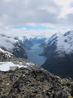
Eikesdalsvatnet is a lake in Nesset Municipality in Møre og Romsdal county, Norway. The lake is long and narrow, roughly 18 kilometres (11 mi) in length, and it is the largest lake in Møre og Romsdal county. The village of Eikesdalen is located at the southern end of the lake.

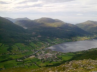
Eresfjorden is a fjord in Nesset Municipality in Møre og Romsdal county, Norway. It is a 10-kilometre (6.2 mi) long branch off of the main Langfjorden, which is itself a branch off the great Romsdal Fjord. The fjord begins at the mouth of the Eira River near the village of Eresfjord, and then it flows north to meet the Langfjorden near the villages of Eidsvåg and Boggestranda.
Boggestranda is a village in Nesset Municipality in Møre og Romsdal county, Norway. It is located along the east shore of the Eresfjorden, about 10 kilometres (6.2 mi) south of the village of Eidsvåg and 10 kilometres (6.2 mi) north of the village of Eresfjord. There are some very old rock carvings in Boggestranda.

Eikesdalen is a valley and a settlement in Nesset Municipality in Møre og Romsdal county, Norway. The river Aura flows through the valley. The village is located at the south end of the lake Eikesdalsvatnet at the mouth of the Aura River. Most of the valley is filled by the lake and until 1991 ferry on the lake was the only access between north and south of the valley.. The Mardalsfossen waterfall lies about 2.5 kilometres (1.6 mi) northwest of the village. Most of the river Aura is diverted to Sunndalen and used in the power station there. The village of Eresfjord is located about 25 kilometres (16 mi) north, at the other end of the lake. The lake Aursjøen lies about 20 kilometres (12 mi) southeast of Eikesdalen village. Eikesdal Church is located in this village.
Eresfjord is a village in Nesset Municipality in Møre og Romsdal county, Norway. Approximately 450 inhabitants reside in the village (2008). The village is located along the Eira River between the Eresfjorden and the lake Eikesdalsvatnet. The mountain Skjorta lies just to the east of the village. The village of Myklebostad lies about 17 kilometres (11 mi) to the northwest through the Vistdal valley and the village of Boggestranda lies about 10 kilometres (6.2 mi) to the north.
Myklebostad is a village in the Vistdal valley in Nesset Municipality in Møre og Romsdal county, Norway. The village is located along the south side of the Langfjorden, just west of the mouth of the Eresfjorden, about 10 kilometres (6.2 mi) southwest of the municipal center of Eidsvåg. The village of Eresfjord lies about 18 kilometres (11 mi) to the southeast through the Vistdal valley. The village was a part of the former municipality of Eresfjord og Vistdal from 1890 until 1964. Vistdal Church is located in Myklebostad.

Rensvik is a village in Kristiansund Municipality in Møre og Romsdal county, Norway. The village is located on the northern part of the island of Frei, just west of the Omsund Bridge which connects to the island of Nordlandet to the north. The 1.65-square-kilometre (410-acre) village has a population (2013) of 2,501; which gives the village a population density of 1,516 inhabitants per square kilometre (3,930/sq mi).

Tingvollvågen or Tingvoll is the administrative centre of Tingvoll Municipality in Møre og Romsdal county, Norway. The village is located on a small inlet off the Tingvollfjorden, directly across the fjord from the village of Angvika. Tingvollvågen lies about 10 kilometres (6.2 mi) north of Meisingset and about 20 kilometres (12 mi) south of Straumsnes. The historic Tingvoll Church is located in this village. Norwegian National Road 70 runs through the village on its way from Kristiansund to Oppdal.

Nesset Church is a parish church in Nesset Municipality in Møre og Romsdal county, Norway. It is located in the village of Eidsvåg. The church is part of the Nesset parish in the Indre Romsdal deanery in the Diocese of Møre. The white wooden church was built in 1878 by the architect Johannes Henrik Nissen. The church seats about 250 people.

The Nesset Parsonage lies 3 kilometers (1.9 mi) southwest of Eidsvåg on the south side of Langfjorden in the municipality of Nesset, Norway.


