Related Research Articles

Franconia is a region of Germany, characterised by its culture and Franconian dialect.

The Saale, also known as the Saxon Saale and Thuringian Saale, is a river in Germany and a left-bank tributary of the Elbe. It is not to be confused with the smaller Franconian Saale, a right-bank tributary of the Main, or the Saale in Lower Saxony, a tributary of the Leine.
Main-Spessart is a Landkreis (district) in the northwest of Bavaria, Germany. It is located in Lower Franconia and derives its name from the river Main and the wooded hills of the Spessart.

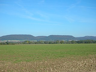
The Rhön Mountains are a group of low mountains in central Germany, located around the border area where the states of Hesse, Bavaria and Thuringia come together. These mountains, which are at the extreme southeast end of the East Hesse Highlands, are partly a result of ancient volcanic activity. They are separated from the Vogelsberg Mountains by the river Fulda and its valley. The highest mountain in the Rhön is the Wasserkuppe, which is in Hesse. The Rhön Mountains are a popular tourist destination and walking area.

Ostheim vor der Rhön is a town in Northern Bavaria in the district of Rhön-Grabfeld in Franconia. Though politically part of Bavaria since 1947, it was historically a part of Thuringia, and remains religiously, architecturally, and to some extent culturally distinct from its immediate surroundings.

Bad Neustadt an der Saale, officially Bad Neustadt a. d. Saale and often simply called Bad Neustadt, is a town in northern Bavaria, Germany. It is the capital of the Rhön-Grabfeld district in Lower Franconia. It is situated on the rivers Fränkische Saale and Brend, near the Rhön Mountains, 30 km north of Schweinfurt, and 47 km southeast of Fulda.

Bad Bocklet is a municipality in the district of Bad Kissingen in Bavaria in Germany. It is a market town and a health spa.

Heustreu is a municipality in the district of Rhön-Grabfeld in Lower Franconia in Germany. It lies on the river Streu.

The Milseburg is an extinct volcano and at 835 metres (2,740 ft) above sea level the second highest elevation in the Hessian part of the Rhön Mountains, Germany. The hill is located east of Fulda, near the villages of Kleinsassen and Danzwiesen. It is a popular destination for hikers and bikers. Scientifically, Milseburg is most notable for the remains of a large Celtic oppidum. It also features several other structures on the peak, including a chapel dedicated to St Gangulphus.

The Mellrichstadt–Fladungen railway, also called the Streu Valley Line, is a Bavarian branch line that connects Mellrichstadt in Lower Franconia with the town of Fladungen, which nestles in the Rhön mountains.
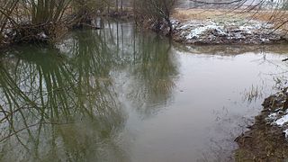
The Streu is a river of Thuringia and Bavaria, Germany.
The Amelungsburg is a former ringfort that is located on the Amelungsberg hill on the Süntel ridge in the district of Hameln-Pyrmont in the German state of Lower Saxony.

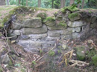
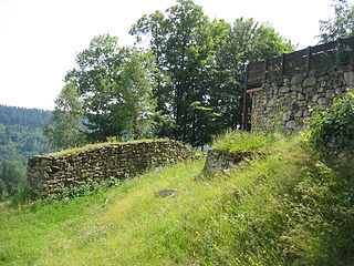
Salzburg Castle stands on the edge of a plateau above the town of Bad Neustadt an der Saale in Lower Franconia in southern Germany. The large Ganerbenburg is still partly occupied today and not all areas are accessible to the public.
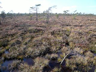
The Black Moor is an important internationally recognised wetland located in the Bavarian Rhön Mountains at the tripoint of the German states of Hesse, Thuringia and Bavaria. It is part of UNESCO's Rhön Biosphere Reserve and has an area of 66.4 hectares. It is thus the largest bog complex in the Rhön. Much of the moor is a largely undisturbed and intact raised bog. It is part of the Europe-wide conservation system, Natura 2000, and one of the most important raised bogs in Central Europe. The Black Moor lies on the watershed between the Rhine and Weser rivers. In 2007 the Black Moor was included in the List of the 100 most beautiful geotopes in Bavaria.
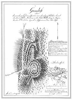
The Burgstall of Schlosshügel near Weidenberg is a lost hill castle or circular rampart site of the type known as a motte from the Early Middle Ages. It lies on the southern perimeter of the Fichtel Mountains at a height of 699 metres above sea level (NN) above the village of Sophienthal, which is part of the market borough of Weidenberg in the Upper Franconia county of Bayreuth in Bavaria. The burgstall or lost castle site was partly investigated by means of an archaeological test excavation and was also mapped several times in the past.
The Alte Burg is an early medieval ringwork between Altenstein and Lichtenstein in the borough of Market Maroldsweisach in the Lower Franconian county of Haßberge in the province of Lower Franconia in Bavaria, Germany.

There are numerous prehistorical and early historical ringworks and fortification ramparts in Central Europe that have erroneously, usually colloquially, been given the name Schwedenschanze, which means "Swedish redoubt", a schanze being a hastily erected, military fieldwork.
The Heunischenburg is a stone fortification of the late Urnfield period near the Upper Franconian town of Kronach in Germany. Its heyday was in the 9th century BC, making it the oldest stone fortification north of the Alps that is known and archaeologically investigated.

The burgstall of the Altes Schloss is the site of an old castle near the village of Affalterthal in Bavaria, that was probably built in the High Middle Ages for the nobility. It lies within the municipality of Egloffstein in the Upper Franconian county of Forchheim.
References
Coordinates: 50°23′50″N10°15′05″E / 50.39722°N 10.25139°E
| General | |
|---|---|
| National libraries | |