The Lahn is a 245.6-kilometre-long (152.6 mi), right tributary of the Rhine in Germany. Its course passes through the federal states of North Rhine-Westphalia (23.0 km), Hesse (165.6 km), and Rhineland-Palatinate (57.0 km).

Wartenberg is a municipality in the Vogelsbergkreis in Hesse, Germany.
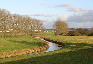
The Schwalm is a river in Hesse, Germany, right tributary of the Eder. It rises on the north side of the Vogelsberg Mountains. It flows north through Alsfeld, Schwalmstadt and Borken. The Schwalm flows into the Eder near Wabern, east of Fritzlar, after a total length of 97 km (60 mi). The main tributaries are the Efze, the Gilsa, the Grenff and the Antrift.

Alsfeld is a town in the center of Hesse, in Germany.

Amöneburg is a town in the Marburg-Biedenkopf district in Hesse, Germany. It lies on a mountain and is built around the castle of the same name, Burg Amöneburg.

Antrifttal is a municipality in the Vogelsbergkreis in Hesse, Germany.
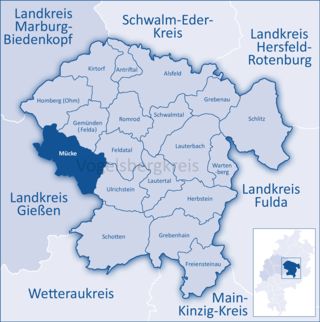
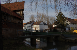
Mücke is a municipality in the Vogelsbergkreis in Hesse, Germany.

Ulrichstein is a small town in the Vogelsbergkreis in Hesse, Germany.

The West Hesse Highlands, also known as the West Hessian Lowlands and Highlands, are a heavily forested region of the Central Uplands in Germany. These highlands lie mainly within the state of Hesse, between that part of the Rhenish Massif right of the Rhine in the west, the Weser Uplands to the north, the Hessian Central Uplands to the east and the Wetterau to the south.

The West Hesse Depression is part of the West Hesse Highlands and Lowlands region in the north of the German state of Hesse. Like the East Hesse Depression, it is a series of separate depressions that form a natural corridor and have been an important historical trade route.
The East Hesse Highlands describes a heavily wooded range of hills lying mainly in the German state of Hesse, but also extending a little way into Lower Saxony to the north, Thuringia to the east and Bavaria to the southeast. The region is sandwiched between the West Hesse Depression to the west, the Weser Uplands to the north, the Thuringian Basin to the northeast, the northwestern edge of the Thuringian Forest to the east, the Spessart to the south and the Wetterau to the southwest.

The Rhünda, also called the Rhündabach, is a 12.9 kilometres (8.0 mi) long, eastern tributary of the River Schwalm in the Schwalm-Eder-Kreis, North Hesse, Germany.

The Grenff, also Grenf, is an approximately 21.9 km long, right-hand or southeasterly tributary of Schwalm in East Hesse Highlands in North Hesse Schwalm-Eder-Kreis and belongs to the river system and catchment area of the Weser.

Urff is a 20.1-kilometre-long (12.5 mi) tributary of the river Schwalm in Waldeck-Frankenberg and Schwalm-Eder-Kreis, North Hesse (Germany). It flows into the Schwalm near Niederurff.
The Gießen–Fulda railway is a single-track main line from Gießen via Alsfeld to Fulda in the German state of Hesse.
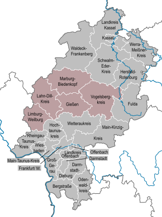
The region of Middle Hesse is one of three planning regions in the German state of Hesse, alongside North and South Hesse. Its territory is identical with that of the administrative province of Gießen and covers the counties of Limburg-Weilburg, Lahn-Dill-Kreis, Gießen, Marburg-Biedenkopf and Vogelsbergkreis. The Middle Hesse Regional Assembly, which decides on the regional plan, currently consists of 31 members chosen by the five counties and the three towns with special status: Gießen, Marburg and Wetzlar. The regional assembly has tasked the governing president (Regierungspräsident) with delivering regional management. The Mid-Hesse Regional Management Association was founded on 22 January 2003.
The Hesse Highlands, Hessian Highlands or Hessian Highlands and Lowlands, are a largely densely forested low mountain area in the German state of Hesse that lies between the Rhenish Massif and the western edge of the Thuringian Basin. The Hesse Highlands are both part of the German Central Uplands and the Rhine-Weser Watershed.

The Upper Hessian Ridge or Upper Hesse Ridge is a hill chain in the West Hesse Highlands in North and Middle Hesse, which lies on the Rhine-Weser watershed and links the montane Central Upland ranges of the Kellerwald and the Vogelsberg in a north-south direction. The swell is divided into the Gilserberg Heights in the north, the central Neustadt Saddle and the Northern Vogelsberg Foreland in the south.

The Langenberg, also colloquially called the Langenberge (plural) due to its several and widely spaced hilltops, is a hill range of the German Central Uplands which covers an area of over 22 km² and reaches a height of 556.7 m above sea level (NHN) at the Schwengeberg. It is a natural region in the Habichtswald Highlands in the counties of Kassel and Schwalm-Eder-Kreis in North Hesse.

The Vogelsberg (help·info) is a large volcanic mountain range in the German Central Uplands in the state of Hesse, separated from the Rhön Mountains by the Fulda river valley. Emerging approximately 19 million years ago, the Vogelsberg is Central Europe's largest basalt formation, consisting of a multitude of layers that descend from their peak in ring-shaped terraces to the base.