Related Research Articles

Washington County is a county in the U.S. state of Wisconsin. As of the 2010 census, the population was 131,887. Its county seat is West Bend. The county was created from Wisconsin Territory in 1836 and organized in 1845. It was named after President George Washington.

Fond du Lac County is a county in the U.S. state of Wisconsin. As of the 2010 census, the population was 101,633. Its county seat is Fond du Lac. The county was created in the Wisconsin Territory in 1836 and later organized in 1844. Fond du Lac is French for "bottom of the lake", so given because of the county's location at the southern shore of Lake Winnebago.

Waupun is a city in Dodge and Fond du Lac counties in the U.S. state of Wisconsin. The population was 11,340 at the 2010 census. Of this, 7,864 were in Dodge County, and 3,476 were in Fond du Lac County. In Fond du Lac County, the Town of Waupun abuts the city of Waupun.

The Ice Age Trail is a National Scenic Trail stretching 1,200 miles (1,900 km) in the state of Wisconsin in the United States. The trail is administered by the National Park Service, and is constructed and maintained by private and public agencies including the Ice Age Trail Alliance, a non-profit and member-volunteer based organization with local chapters.
Fond du Lac is a city in Fond du Lac County, Wisconsin, United States. The population was 43,021 at the 2010 census. The city forms the core of the United States Census Bureau's Fond du Lac Metropolitan Statistical Area, which includes all of Fond du Lac County. Fond du Lac is the 342nd largest Metropolitan Statistical Area (MSA) in the United States. The Fond du Lac MSA and the Beaver Dam (city), Wisconsin Micropolitan Statistical Area, form the larger Fond du Lac-Beaver Dam Combined Statistical Area.

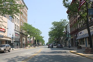
West Bend is the county seat of Washington County, Wisconsin, United States, in southeastern Wisconsin. As of the 2010 census, the population was 31,078.

The Rock River is a tributary of the Mississippi River, approximately 299 miles (481 km) long, in the U.S. states of Wisconsin and Illinois. The river was known as the Sinnissippi to Sauk and Fox Indians; the name means "rocky waters".

Kettle Moraine is a large moraine in the state of Wisconsin, United States. It stretches from Walworth County in the south to Kewaunee County in the north. It has also been referred to as the Kettle Range and, in geological texts, as the Kettle Interlobate Moraine.
The Kettle Moraine State Forest is a state forest in southeastern Wisconsin. The chief feature of the reserve is the Kettle Moraine, a highly glaciated area. The area contains very hilly terrain and glacial landforms, such as kettles, kames and eskers. The 56,000-acre (23,000 ha) forest is divided into two large and three small units, which are spread across a hundred miles.

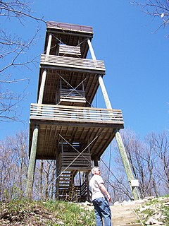
Lapham Peak is a Wisconsin state park located in the Kettle Moraine State Forest. It is just south of Delafield and seven miles (11 km) west of Waukesha. The park entrance is two miles (3 km) north of the Glacial Drumlin State Trail.
Kettle Moraine Lutheran High School (KMLHS) is a four-year Lutheran high school in the Town of Jackson, Wisconsin, located approximately 20 miles northwest of Milwaukee. The school is affiliated with the Wisconsin Evangelical Lutheran Synod (WELS).

Dundee is an unincorporated community located in the town of Osceola, in Fond du Lac County, Wisconsin, United States. It is located on Wisconsin Highway 67 in the Kettle Moraine State Forest. The Kettle Moraine Scenic Drive runs through the community.

Moraine Park Technical College (MPTC) is a public technical college with multiple locations in Wisconsin. It is part of the Wisconsin Technical College System and awards associate of applied science degrees, technical diplomas, and certificates. Traditional classroom, online, and blended formats are available at the college's campuses in Beaver Dam, Fond du Lac, and West Bend.
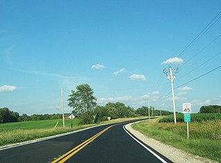
The Kettle Moraine Scenic Drive is a designated scenic route in southeastern Wisconsin that links the two units of the Kettle Moraine State Forest. The route traverses through scenic and historic areas, including landscape shaped by glaciers from the latest ice age, known as the Wisconsin glaciation.
Winnebago Lutheran Academy, also known as WLA, is a private Lutheran high school in Fond du Lac, Wisconsin, associated with the Wisconsin Evangelical Lutheran Synod (WELS).
Mascoutin Valley State Trail is a rail trail in northeastern Wisconsin. The trail is used for walking, bicycling, horseback riding, and snowmobiling during the winter months. The trail can also be used for cross-country skiing and snowshoeing but the trail is not groomed and must be shared with snowmobiles. Numerous miles of snowmobile trails connect to the Mascoutin Valley State Trail.
The Kettle Moraine Correctional Institution is a medium security penitentiary located 10 miles west of Plymouth, Wisconsin, USA off Wisconsin Highway 67 just east of the Sheboygan/Fond du Lac County line.

The Southern Unit of the Kettle Moraine State Forest includes more than 22,000 acres of land throughout southern Wisconsin and spans several state parks and natural areas. The area also features varied environments from restored prairie, forests, and lakes, along with providing a multitude of recreational opportunities such as hiking, birdwatching, fishing, camping, and hunting. The Kettle Moraine Scenic Drive also extends within this region as well as through a larger portion of the state.
References
- 1 2 "Eisenbahn State Park Trail". Fond Du Lac County. Retrieved 22 August 2014.
- ↑ "Eisenbahn State Trail". Wisconsin DNR.
- ↑ "Moraine Park campus connects to Eisenbahn State Trail". fdlreporter. Retrieved 9 October 2014.
- ↑ "Eisenbahn State Trail". TrailLink. Retrieved 22 August 2014.
- ↑ "Golf & Parks Division | Washington County, WI". www.co.washington.wi.us. Retrieved 2018-05-30.
- 1 2 "Eisenbahn State Trail". Washington County. Retrieved 22 August 2014.