Eden, Wisconsin

Last updated
Eden
Village
EdenWisconsinDowntown.jpg
Downtown Eden on US 45
Fond du Lac County Wisconsin Incorporated and Unincorporated areas Eden Highlighted.svg
Location of Eden in Fond du Lac County, Wisconsin
USA Wisconsin location map.svg
Red pog.svg
Eden
Location within the state of Wisconsin
Coordinates: 43°41′35″N88°21′42″W / 43.69306°N 88.36167°W / 43.69306; -88.36167 Coordinates: 43°41′35″N88°21′42″W / 43.69306°N 88.36167°W / 43.69306; -88.36167
Country Flag of the United States.svg  United States
State Flag of Wisconsin.svg  Wisconsin
County   Fond du Lac
Area
[1]
  Total0.62 sq mi (1.60 km2)
  Land0.60 sq mi (1.55 km2)
  Water0.02 sq mi (0.04 km2)
Population
 (2010) [2]
  Total875
  Estimate 
(2019) [3]
932
  Density1,553.33/sq mi (599.47/km2)
Time zone UTC-6 (Central (CST))
  Summer (DST) UTC-5 (CDT)
Area code 920
FIPS code 55-22475

Eden is a village in Fond du Lac County, Wisconsin, United States. The population was 875 at the 2010 census. The village is located within the Town of Eden.

Contents

History

A post office called Eden was first established in 1850. [4] Eden was named after either the Garden of Eden or after John Eden, an early settler. [5]

Geography

Eden is located at 43°41′35″N88°21′42″W / 43.69306°N 88.36167°W / 43.69306; -88.36167 (43.693077, -88.361805). [6]

According to the United States Census Bureau, the village has a total area of 0.62 square miles (1.61 km2), of which 0.60 square miles (1.55 km2) of it is land and 0.02 square miles (0.05 km2) is water. [7]

Demographics

Historical population
CensusPop.Note
1880 83
1920 176
1930 22326.7%
1940 2230.0%
1950 2344.9%
1960 31233.3%
1970 37620.5%
1980 53442.0%
1990 61014.2%
2000 68712.6%
2010 87527.4%
2019 (est.)932 [3] 6.5%
U.S. Decennial Census [8]

2010 census

As of the census [2] of 2010, there were 875 people, 337 households, and 235 families living in the village. The population density was 1,458.3 inhabitants per square mile (563.1/km2). There were 360 housing units at an average density of 600.0 per square mile (231.7/km2). The racial makeup of the village was 94.5% White, 0.2% African American, 0.7% Native American, 0.3% Asian, 2.6% from other races, and 1.6% from two or more races. Hispanic or Latino of any race were 4.7% of the population.

There were 337 households, of which 35.6% had children under the age of 18 living with them, 55.5% were married couples living together, 8.3% had a female householder with no husband present, 5.9% had a male householder with no wife present, and 30.3% were non-families. 24.3% of all households were made up of individuals, and 9.2% had someone living alone who was 65 years of age or older. The average household size was 2.60 and the average family size was 3.09.

The median age in the village was 34.3 years. 25.5% of residents were under the age of 18; 11.4% were between the ages of 18 and 24; 26.8% were from 25 to 44; 23.6% were from 45 to 64; and 12.8% were 65 years of age or older. The gender makeup of the village was 50.2% male and 49.8% female.

2000 census

As of the census [9] of 2000, there were 687 people, 264 households, and 181 families living in the village. The population density was 1,321.2 people per square mile (510.1/km2). There were 303 housing units at an average density of 582.7 per square mile (225.0/km2). The racial makeup of the village was 98.11% White, 0.15% Native American, 1.46% from other races, and 0.29% from two or more races. 4.22% of the population were Hispanic or Latino of any race.

There were 264 households, out of which 35.2% had children under the age of 18 living with them, 58.7% were married couples living together, 7.2% had a female householder with no husband present, and 31.1% were non-families. 25.0% of all households were made up of individuals, and 10.2% had someone living alone who was 65 years of age or older. The average household size was 2.60 and the average family size was 3.16.

In the village, the population was spread out, with 30.4% under the age of 18, 6.6% from 18 to 24, 31.9% from 25 to 44, 17.5% from 45 to 64, and 13.7% who were 65 years of age or older. The median age was 34 years. For every 100 females, there were 102.7 males. For every 100 females age 18 and over, there were 98.3 males.

The median income for a household in the village was $41,579, and the median income for a family was $48,571. Males had a median income of $35,804 versus $22,031 for females. The per capita income for the village was $19,614. About 3.4% of families and 4.2% of the population were below the poverty line, including 6.5% of those under age 18 and 5.8% of those age 65 or over.

Notable people

Images

Related Research Articles

<span class="mw-page-title-main">Brook Highland, Alabama</span> Census-designated place & Unincorporated community in Alabama, United States

Brook Highland is an unincorporated community and census-designated place in Shelby County, Alabama, United States. At the 2020 census, the population was 7,406.

<span class="mw-page-title-main">Palmetto Estates, Florida</span> Census-designated place in Florida, United States

Palmetto Estates is an unincorporated area and census-designated place (CDP) in Miami-Dade County, Florida, United States. The population was 13,498 at the 2020 census.

<span class="mw-page-title-main">Searsmont, Maine</span> Town in the state of Maine, United States

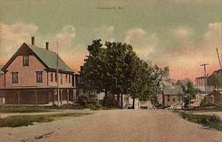
Searsmont is a town in Waldo County, Maine, United States. The population was 1,400 at the 2020 census.

<span class="mw-page-title-main">Isleta Village Proper, New Mexico</span> Census-designated place in New Mexico, United States

Isleta Village Proper is a census-designated place (CDP) in Bernalillo County, New Mexico, United States. The population was 491 at the 2010 census. It is part of the Albuquerque Metropolitan Statistical Area.

Lyons Falls is a village in Lewis County, New York, United States. The population was 566 at the 2010 census. The village is on the border of the towns of West Turin and Lyonsdale. It is at the junction of state Routes 12 and 12D, approximately 14 miles (23 km) south of Lowville, the county seat.

<span class="mw-page-title-main">Oceana, West Virginia</span> Town in West Virginia, United States

Oceana is a town in Wyoming County, West Virginia. The population was 1,462 at the time of the 2020 census. Oceana is the oldest city in Wyoming County and was the county seat until 1907. Oceana was the eponym of the film Oxyana. The town has a town hall and a local police department. It is home to the only McDonald's in Wyoming County.

<span class="mw-page-title-main">Oliver, Wisconsin</span> Village in Wisconsin, United States

Oliver is a village in Douglas County, Wisconsin, United States. The population was 423 at the 2020 census.

<span class="mw-page-title-main">Big Falls, Waupaca County, Wisconsin</span> Village in Wisconsin, United States

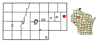
Big Falls is a village in Waupaca County, Wisconsin, United States. The population was 61 at the 2010 census.

<span class="mw-page-title-main">Viola, Wisconsin</span> Village in Wisconsin, United States

Viola is a village in Richland (mostly) and Vernon Counties in the U.S. state of Wisconsin, United States. The population was 699 at the 2010 census. Of this, 477 were in Richland County, and 222 were in Vernon County.

Hammond is a village in St. Lawrence County, New York, United States. The population was 280 at the 2010 census. The village is named after an early landowner.

<span class="mw-page-title-main">Wyocena, Wisconsin</span> Village in Wisconsin, United States

Wyocena is a village in Columbia County, Wisconsin, United States. The population was 768 at the 2010 census. The village is located within the Town of Wyocena. It is part of the Madison Metropolitan Statistical Area.

<span class="mw-page-title-main">Lowell, Wisconsin</span> Village in Wisconsin, United States

Lowell is a village in Dodge County, Wisconsin, United States, along the Beaver Dam River. The population was 340 at the 2010 census. The village is located within the Town of Lowell.

<span class="mw-page-title-main">Colfax, Wisconsin</span> Village in Wisconsin, United States

Colfax is a village in Dunn County, Wisconsin, United States. The population was 1,158 at the 2010 census. The village is surrounded by the Town of Colfax.

Eden is a town in Fond du Lac County, Wisconsin, United States. The population was 979 at the 2000 census. The Village of Eden is located within the town. The unincorporated community of Marblehead is located also in the town.

Oakfield is a town in Fond du Lac County, Wisconsin, United States. The population was 767 at the 2000 census. The Village of Oakfield is located within the town. The unincorporated community of Oak Center is also located in the town.

<span class="mw-page-title-main">Mount Hope, Wisconsin</span> Village in Wisconsin, United States

Mount Hope is a village in Grant County, Wisconsin, United States. The population was 225 at the 2010 census. The village is located within the Town of Mount Hope.

<span class="mw-page-title-main">Melrose, Wisconsin</span> Village in Wisconsin, United States

Melrose is a village in Jackson County, Wisconsin, United States. The population was 503 at the 2010 census. The village is located within the Town of Melrose.

<span class="mw-page-title-main">Hawkins, Wisconsin</span> Village in Wisconsin, United States

Hawkins is a village in Rusk County, Wisconsin, United States. The population was 305 at the 2010 census. The village is located within the Town of Hawkins.

<span class="mw-page-title-main">Aniwa, Wisconsin</span> Village in Wisconsin, United States

Aniwa is a village in Shawano County, Wisconsin, United States. The population was 260 at the 2010 census. The village is located within the Town of Aniwa. U.S. Route 45 runs north–south through the village.

<span class="mw-page-title-main">Scandinavia, Wisconsin</span> Village in Wisconsin, United States

Scandinavia is a village in the Town of Scandinavia in Waupaca County, Wisconsin, United States. The population was 328 at the 2010 census.

References

  1. "2019 U.S. Gazetteer Files". United States Census Bureau. Retrieved August 7, 2020.
  2. 1 2 "U.S. Census website". United States Census Bureau . Retrieved 2012-11-18.
  3. 1 2 "Population and Housing Unit Estimates". United States Census Bureau. May 24, 2020. Retrieved May 27, 2020.
  4. "Fond du Lac County". Jim Forte Postal History. Archived from the original on 2 April 2015. Retrieved 17 March 2015.
  5. Chicago and North Western Railway Company (1908). A History of the Origin of the Place Names Connected with the Chicago & North Western and Chicago, St. Paul, Minneapolis & Omaha Railways. p. 67.
  6. "US Gazetteer files: 2010, 2000, and 1990". United States Census Bureau. 2011-02-12. Retrieved 2011-04-23.
  7. "US Gazetteer files 2010". United States Census Bureau. Archived from the original on 2012-01-25. Retrieved 2012-11-18.
  8. "Census of Population and Housing". Census.gov. Retrieved June 4, 2015.
  9. "U.S. Census website". United States Census Bureau . Retrieved 2008-01-31.