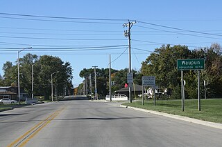
Waupun is a city in Dodge and Fond du Lac counties in the U.S. state of Wisconsin. The population was 11,340 at the 2010 census. Of this, 7,864 were in Dodge County, and 3,476 were in Fond du Lac County. In Fond du Lac County, the Town of Waupun abuts the city of Waupun.
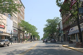
Fond du Lac is a city in Fond du Lac County, Wisconsin, United States. The population was 43,021 at the 2010 census. The city forms the core of the United States Census Bureau's Fond du Lac Metropolitan Statistical Area, which includes all of Fond du Lac County. Fond du Lac is the 342nd largest Metropolitan Statistical Area (MSA) in the United States. The Fond du Lac MSA and the Beaver Dam (city), Wisconsin Micropolitan Statistical Area, form the larger Fond du Lac-Beaver Dam Combined Statistical Area.
The Fond du Lac Indian Reservation is an Indian reservation in northern Minnesota near Cloquet in Carlton and Saint Louis counties. Off-reservation holdings are located across the state in Douglas County, in the northwest corner of Wisconsin. The total land area of these tribal lands is 153.8375 square miles (398.437 km2). It is the land-base for the Fond du Lac Band of Lake Superior Chippewa. Before the establishment of this reservation, the Fond du Lac Band of Lake Superior Chippewa were located at the head of Lake Superior, closer to the mouth of the Saint Louis River, where Duluth has developed.

The Diocese of Fond du Lac is a diocese of the Episcopal Church in the United States of America, encompassing the northeastern third of Wisconsin. The diocese contains about 5,700 baptized members worshipping in 37 locations. It is part of Province 5. Diocesan offices are in Appleton, Wisconsin. The Diocesan Archives are maintained in Grafton Hall behind the Cathedral in Fond du Lac. Matthew Gunter is its bishop.

Wisconsin's 6th congressional district is a congressional district of the United States House of Representatives in eastern Wisconsin. Located in the rural communities surrounding Madison, Milwaukee, and Green Bay. It also includes a small portion of far northern Milwaukee County around River Hills. The district is represented by Glenn Grothman (R-Campbellsport) who came to office in January 2015.

Johnsburg, Wisconsin is an unincorporated community in the Town of Calumet in Fond du Lac County, Wisconsin. The community is located on County Roads Q and W, approximately 3.3 miles (5.3 km) east of Lake Winnebago, 2.75 miles (4.43 km) southeast of Pipe and 1.4 miles (2.3 km) northwest of Malone. Johnsburg is part of the Holyland region in northeastern Fond du Lac county.

New Fane, Wisconsin is an unincorporated community in the Town of Auburn in Fond du Lac County, Wisconsin, United States. The community is located in the heart of the northern unit of the Kettle Moraine State Forest. The community is located on County Road S and DD.
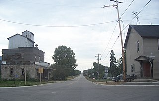
Marytown, Wisconsin is an unincorporated community in Fond du Lac County, Wisconsin, in the town of Calumet. Marytown is located at the intersection of Fond du Lac County highways G and HH. Wisconsin Highway 149 ran north to south through the community before it was decommissioned in 2006.

Calumetville is an unincorporated community that straddles the county line between Calumet and Fond du Lac counties in Wisconsin. The main part of the community in Fond du Lac County lies in the town of Calumet, and the part in Calumet County lies in the town of Brothertown.

Van Dyne is an unincorporated census-designated place in the town of Friendship, in Fond du Lac County, Wisconsin, United States. At the 2010 census, its population is 279. The road traveling north-south through the community was part of the Yellowstone Trail and later Wisconsin Highway 175; it is now a county highway.
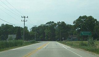
Taycheedah, Wisconsin is an unincorporated census-designated place in the Town of Taycheedah in Fond du Lac County, Wisconsin. The community is located adjacent to the city of Fond du Lac and Lake Winnebago. As of the 2010 census, its population is 704. Taycheedah calls itself the "Sheepshead Fishing Center of the World". U.S. Route 151 ran through the community until a bypass around Fond du Lac was built in the 2000s.

Peebles, Wisconsin is an unincorporated community in the Town of Taycheedah in Fond du Lac County, Wisconsin. The community is located adjacent to the unincorporated community of Taycheedah. U.S. Route 151 runs through the community. Wisconsin Highway 149 used to run through the community at its western terminus until it was decommissioned in 2006. Taycheedah Correctional Institution is located in the town of Taycheedah several miles south of the community.

St. Peter, Wisconsin is an unincorporated census-designated place in the Town of Taycheedah in Fond du Lac County, Wisconsin. It is located approximately 2 miles (3.2 km) northeast of Peebles and 1 mile (1.6 km) south of Silica. It was located on Wisconsin Highway 149 before the highway was decommissioned and turned over to county control as County Highway WH. As of the 2010 census, its population is 1,489.

The Fond du Lac State Forest is a state forest in Minnesota, United States, principally managed by the Minnesota Department of Natural Resources (MDNR). The main segment of the forest is located between the towns of Sawyer and Cromwell, in Carlton County. The boundaries of the forest overlap with those of the Fond du Lac Indian Reservation, some state forest land falls within the reservation. The Kettle Lake Wildlife Management Area is located in the southern half of the main segment. A smaller segment is located adjacent to Jay Cooke State Park and the border with Wisconsin in Saint Louis County.

Byron is an unincorporated community located, in the town of Byron, in Fond du Lac County, Wisconsin, United States. Byron is 3 miles (4.8 km) northeast of Brownsville on Wisconsin Highway 175.
Eldorado is an unincorporated community located in the town of Eldorado, Fond du Lac County, Wisconsin, United States. Eldorado is 2.5 miles (4.0 km) east-northeast of Rosendale. Eldorado has a post office with ZIP code 54932.

Waucousta is an unincorporated community in the town of Osceola, in Fond du Lac County, Wisconsin, United States. Waucousta is located at the junction of U.S. Route 45 and County Highway F, 4 miles (6.4 km) north-northeast of Campbellsport. A branch of the Milwaukee River runs through the community.
Woodhull is an unincorporated community located in the town of Lamartine, Fond du Lac County, Wisconsin, United States.
Metomen is an unincorporated community in the town of Metomen, Fond du Lac County, Wisconsin, United States. The community is located on Brandon Road.


