
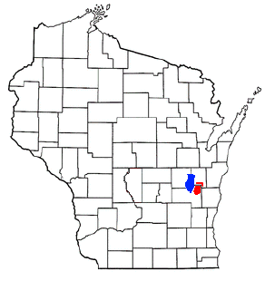
Fond du Lac County is a county in the U.S. state of Wisconsin. As of the 2020 census, the population was 104,154. Its county seat is Fond du Lac. The county was created in the Wisconsin Territory in 1836 and later organized in 1844. Fond du Lac is French for "bottom of the lake", given so because of the county's location at the southern shore of Lake Winnebago. Fond du Lac County comprises the Fond du Lac, Wisconsin Metropolitan Statistical Area. The Holyland region is in northeastern Fond du Lac County.

Mount Calvary is a village in Fond du Lac County, Wisconsin, United States. The population was 762 at the 2010 census, down from 956 residents at the 2000 census.
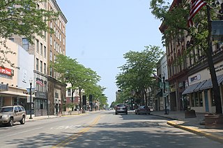
Fond du Lac is a city in and the county seat of Fond du Lac County, Wisconsin, United States. The population was 44,678 at the 2020 census. The city forms the core of the Fond du Lac metropolitan statistical area, which includes all of Fond du Lac County. Fond du Lac is the 348th-largest metropolitan area in the United States.

Malone is an unincorporated community located in Fond du Lac County, Wisconsin near the Sheboygan River and Mt. Calvary, in the towns of Marshfield, and Taycheedah. Malone is located in The Holyland region of Wisconsin. It is home to a post office.

State Trunk Highway 149 was a state highway in the U.S. state of Wisconsin. It ran through 40.1 miles (64.5 km) of Manitowoc, Calumet, and Fond du Lac counties.

Pipe, Wisconsin is an unincorporated community in the Town of Calumet in Fond du Lac County, Wisconsin, United States. It is located approximately 1 mile (1.6 km) east of Lake Winnebago.

Johnsburg, Wisconsin is an unincorporated community in the Town of Calumet in Fond du Lac County, Wisconsin. The community is located on County Roads Q and W, approximately 3.3 miles (5.3 km) east of Lake Winnebago, 2.75 miles (4.43 km) southeast of Pipe and 1.4 miles (2.3 km) northwest of Malone. Johnsburg is part of the Holyland region in northeastern Fond du Lac county.

New Fane is an unincorporated community in the Town of Auburn in Fond du Lac County, Wisconsin, United States. The community is located in the heart of the northern unit of the Kettle Moraine State Forest. The community is located on County Road S and DD.

Calumetville is an unincorporated community that straddles the county line between Calumet and Fond du Lac counties in Wisconsin. The main part of the community in Fond du Lac County lies in the town of Calumet, and the part in Calumet County lies in the town of Brothertown.

St. Anna is an unincorporated community in Calumet and Sheboygan Counties in the U.S. state of Wisconsin. It lies in the towns of Russell and New Holstein.
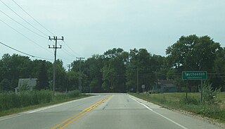
Taycheedah, Wisconsin is an unincorporated census-designated place in the Town of Taycheedah in Fond du Lac County, Wisconsin. The community is located adjacent to the city of Fond du Lac and Lake Winnebago. As of the 2010 census, its population is 704. Taycheedah calls itself the "Sheepshead Fishing Center of the World". U.S. Route 151 ran through the community until a bypass around Fond du Lac was built in the 2000s.
The Holyland is an American region located mainly in northeastern Fond du Lac County, Wisconsin and southern Calumet County. The area is known for its distinctive agricultural landscape, a close-knit community life, and deep Roman Catholicism brought by Germans who first settled the region in the 1840s. The area has been studied as an example of chain migration. It has been called "The Holyland" since at least 1898.

Peebles, Wisconsin is an unincorporated community in the Town of Taycheedah in Fond du Lac County, Wisconsin. The community is located adjacent to the unincorporated community of Taycheedah. U.S. Route 151 runs through the community. Wisconsin Highway 149 used to run through the community at its western terminus until it was decommissioned in 2006. Taycheedah Correctional Institution is located in the town of Taycheedah several miles south of the community.

The Malone Area Heritage Museum is a historical museum in Malone, Wisconsin, United States. The museum documents the history of immigrants into the Holyland region of Wisconsin. The museum is affiliated with the Wisconsin Historical Society. It has been in existence since 2005. It is open to the public on Thursday afternoons between 2:00 and 4:00 pm and on the second Sunday of each month.

St. Joe is an unincorporated community in the town of Marshfield in Fond du Lac County, Wisconsin, United States. The community is located on County Highway G in the northeast portion of the county, 2.5 miles (4.0 km) northwest of St. Cloud and 3.5 miles (5.6 km) northeast of Mount Calvary. It is considered part of the Holyland.

St. Peter, Wisconsin is an unincorporated census-designated place in the Town of Taycheedah in Fond du Lac County, Wisconsin. It is located approximately 2 miles (3.2 km) northeast of Peebles and 1 mile (1.6 km) south of Silica. It was located on Wisconsin Highway 149 before the highway was decommissioned and turned over to county control as County Highway WH. As of the 2010 census, its population is 1,489.

Calvary, Wisconsin is an unincorporated community located in the town of Marshfield, in Fond du Lac County, Wisconsin. The community was originally known locally as Calvary Station since the community was built around the railroad depot for Mount Calvary. The depot for the Sheboygan-Fond du Lac Railroad needed to be built about 1 mile (2 km) north of the community because of the grade needed for trains to climb the Niagara Escarpment. It is located at the intersection of County Highways WW and WH. It is located in the heart of the Blue Sky Green Field Wind Farm in Wisconsin's Holyland Region.
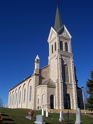
The St. John the Baptist Roman Catholic Church is a Roman Catholic church in Johnsburg in Fond du Lac County, Wisconsin. The church is part of the Roman Catholic Archdiocese of Milwaukee. It was listed on the National Register of Historic Places in 1980.

In Milwaukee, freeways were constructed in response to an 8.5% increase in population during the 1940s. Road plans were drawn up in the 1950s through the 1970s and several freeways were built. A lack of foresight resulted in several communities experiencing sharp increases in property taxes such as in West Milwaukee, or the complete destruction of vibrant, African-American neighborhoods such as Bronzeville. After a decade of aggressive highway building in the 1960s, support for freeway construction began to wane as neighborhoods started to oppose construction. With the election of John Norquist as mayor in 1988, Milwaukee began to undo some of the damage of its highway construction. The dismantling of the Park East Freeway north of downtown led to a housing and entertainment construction boom and is the location of Fiserv Forum.
The Sisterhood of the Holy Nativity (SHN) is an Anglican religious order for women founded in 1882 by Charles Chapman Grafton SSJE. Three sisters and six novices of the Society of St. Margaret (SSM), associated with the Cowley Fathers, left SSM in 1882 to establish the new order. Sister Ruth Margaret Vose (1826-1910) was its first mother superior. The order was incorporated in Wisconsin on May 29, 1921, and remains active in the Episcopal Diocese of Fond du Lac.


