
A glacier is a persistent body of dense ice that is constantly moving under its own weight. A glacier forms where the accumulation of snow exceeds its ablation over many years, often centuries. It acquires distinguishing features, such as crevasses and seracs, as it slowly flows and deforms under stresses induced by its weight. As it moves, it abrades rock and debris from its substrate to create landforms such as cirques, moraines, or fjords. Although a glacier may flow into a body of water, it forms only on land and is distinct from the much thinner sea ice and lake ice that form on the surface of bodies of water.

Glaciology is the scientific study of glaciers, or more generally ice and natural phenomena that involve ice.

The Zugspitze, at 2,962 m (9,718 ft) above sea level, is the highest peak of the Wetterstein Mountains and the highest mountain in Germany. It lies south of the town of Garmisch-Partenkirchen in Bavaria, and the Austria–Germany border is on its western summit. South of the mountain is the Zugspitzplatt, a high karst plateau with numerous caves. On the flanks of the Zugspitze are two glaciers, the largest in Germany: the Northern Schneeferner with an area of 30.7 hectares and Höllentalferner with an area of 24.7 hectares. Shrinking of the Southern Schneeferner led to the loss of glacier status in 2022.

The Byrd Polar and Climate Research Center (BPCRC) is a polar, alpine, and climate research center at The Ohio State University founded in 1960.
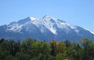
Mount Sopris is a twin-summit mountain in the northwestern Elk Mountains range of the Rocky Mountains of North America. The prominent 12,965-foot (3,952 m) mountain is located in the Maroon Bells-Snowmass Wilderness of White River National Forest, 6.6 miles (10.7 km) north by northeast of the community of Redstone in Pitkin County, Colorado, United States.

Pine Island Glacier (PIG) is a large ice stream, and the fastest melting glacier in Antarctica, responsible for about 25% of Antarctica's ice loss. The glacier ice streams flow west-northwest along the south side of the Hudson Mountains into Pine Island Bay, Amundsen Sea, Antarctica. It was mapped by the United States Geological Survey (USGS) from surveys and United States Navy (USN) air photos, 1960–66, and named by the Advisory Committee on Antarctic Names (US-ACAN) in association with Pine Island Bay.

Folgefonna National Park is a 545.2-square-kilometre (210.5 sq mi) national park in Vestland county, Norway. The park is located on the Folgefonna peninsula, and it spans the municipalities of Kvinnherad, Etne, and Ullensvang. The national park was opened by Queen Sonja on 14 May 2005.

Glacier morphology, or the form a glacier takes, is influenced by temperature, precipitation, topography, and other factors. The goal of glacial morphology is to gain a better understanding of glaciated landscapes and the way they are shaped. Types of glaciers can range from massive ice sheets, such as the Greenland ice sheet, to small cirque glaciers found perched on mountain tops. Glaciers can be grouped into two main categories:

The Weichselian glaciation was the last glacial period and its associated glaciation in northern parts of Europe. In the Alpine region it corresponds to the Würm glaciation. It was characterized by a large ice sheet that spread out from the Scandinavian Mountains and extended as far as the east coast of Schleswig-Holstein, northern Poland and Northwest Russia. This glaciation is also known as the Weichselian ice age, Vistulian glaciation, Weichsel or, less commonly, the Weichsel glaciation, Weichselian cold period (Weichsel-Kaltzeit), Weichselian glacial (Weichsel-Glazial), Weichselian Stage or, rarely, the Weichselian complex (Weichsel-Komplex).
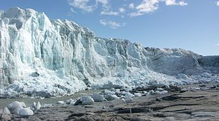
Russell Glacier is a glacier in the Qeqqata municipality in central-western Greenland. It flows from the Greenland ice sheet in the western direction. The front of the glacier is located 25 km (16 mi) east of Kangerlussuaq. It is active, advancing 25 m (82 ft) every year, and, due to easy access from Kangerlussuaq, it remains a popular place for tourists to visit.

The Schneeferner in the Bavarian Alps is Germany's highest and largest glacier.
The glacial series refers to a particular sequence of landforms in Central Europe that were formed during the Pleistocene glaciation beneath the ice sheets, along their margins and on their forelands during each glacial advance.

Manfred Ferdinand Buchroithner is an Austrian cartographer, developer of autostereoscopic cartographic visualisations, geologist, mountain researcher and mountaineer.

The Übergossene Alm is the name of the summit region of the Hochkönig (2,941 m) in the Berchtesgaden Alps. It contains the remains of a glacier that used to cover almost the entire summit plateau; in 1888 around 5.5 km² of the plateau was covered by an ice sheet. Since then the glacial surface has melted until it now covers just 1.5 km² and the glacier has split into three, small crevasse-free areas. The name of the glacier goes back to a local legend.
Akuliarutsip Sermerssua, also known as Nordenskiöld Glacier,, is a large glacier located on the east coast of Greenland.

The Lindbergh Range or Lindbergh Nunataks is a mountain range in King Christian IX Land, eastern Greenland. Administratively the range is part of the Sermersooq Municipality.

Hiawatha Glacier is a glacier in northwest Greenland, with its terminus in Inglefield Land. It was mapped in 1922 by Lauge Koch, who noted that the glacier tongue extended into Lake Alida. Hiawatha Glacier attracted attention in 2018 because of the discovery of a crater beneath the surface of the ice sheet in the area. A publication noted in 1952 that Hiawatha Glacier had been retreating since 1920.
The Schlatenkees is a glacier in the Venediger Group that is in the core zone of the High Tauern National Park, east of the Großvenediger. It is in the East Tyrolean community of Matrei in Osttirol. With an area of around 9 square kilometres (3.5 sq mi), the Schlatenkees is the largest valley glacier in East Tyrol and, after the Obersulzbachkees, the second largest glacier in the Venediger group. The exposure is mainly to the east, in the highest area also to the south-east.

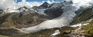
The Vernagtferner is a glacier located in the Ötztal Alps in Tyrol, Austria, which covers an area of 7.31 km², making it one of the largest glaciers in the Eastern Alps. The glacier is situated on the southern side of the Weißkamm. The Hochvernagtspitze and the Brochkogel are the highest mountains within its catchment region. While some maps divide Vernagtferner into Kleiner Vernagtferner and Großer Vernagtferner, with the eastern portion of the Brochkogel area referred to as Kleiner Vernagtferner, these sub-areas do not meet scientific criteria for separate designation.
