
Oaxaca, officially the Free and Sovereign State of Oaxaca, is one of the 32 states that compose the Federative Entities of Mexico. It is divided into 570 municipalities, of which 418 are governed by the system of usos y costumbres with recognized local forms of self-governance. Its capital city is Oaxaca de Juárez.

Coatzacoalcos is a major port city in the southern part of the Mexican state of Veracruz, mostly on the western side of the Coatzacoalcos River estuary, on the Bay of Campeche, on the southern Gulf of Mexico coast. The city serves as the municipal seat of the municipality of the same name. It is the state's third largest city, after Veracruz City and Xalapa.

The Isthmus of Tehuantepec is an isthmus in Mexico. It represents the shortest distance between the Gulf of Mexico and the Pacific Ocean. Before the opening of the Panama Canal, it was a major overland transport route known simply as the Tehuantepec Route. The name is taken from the town of Santo Domingo Tehuantepec in the state of Oaxaca; this was derived from the Nahuatl term Tēcuāntepēc.

Juchitán de Zaragoza is an indigenous town in the southeast of the Mexican state of Oaxaca. It is part of the Juchitán District in the west of the Istmo de Tehuantepec region. With a 2005 census population of 74,714 inhabitants, it is the fourth-largest city in the state. The majority of the indigenous inhabitants are Zapotecs and Huaves. The town also serves as the municipal seat for the surrounding municipality, with which it shares a name. The municipality has an area of 414.64 km² and a population of 85,869, the state's third-largest in population.

Uxpanapa is a municipality in the southeastern part of the state of Veracruz, adjacent to the state of Oaxaca), in Mexico. It is bordered by the municipalities of Jesús Carranza, Hidalgotitlán, Minatitlán, and Las Choapas in Veracruz, as well as Santa María Chimalapa in Oaxaca. It has an area of 2,600 km².
The Zoque are an indigenous people of Mexico. They speak variants of the Zoque languages.

The Sierra Madre de Oaxaca is a mountain range in southern Mexico. It is primarily in the state of Oaxaca, and extends north into the states of Puebla and Veracruz.

The Coatzacoalcos is a large river that feeds mainly the south part of the state of Veracruz; it originates in the Sierra de Niltepec and crosses the state of Oaxaca in the region of the Isthmus of Tehuantepec, flowing for 325 kilometres toward the Gulf of Mexico. Tributaries include El Corte, Sarabia, Jaltepec, Chalchijalpa, El Chiquito, Uxpanapa, and Calzadas. The merging of all these rivers creates one of the largest current flows in the entire region. Two-thirds of the streams are navigable.
San Miguel Chimalapa is a town and municipality in Oaxaca in south-western Mexico. It is part of the Juchitán District in the west of the Istmo de Tehuantepec region.
Santa María Chimalapa is a town and municipality in Oaxaca in south-western Mexico. It is part of the Juchitán District in the west of the Istmo de Tehuantepec region.
Santa María Petapa is a town and municipality in Oaxaca in south-western Mexico. It is part of the Juchitán District in the west of the Istmo de Tehuantepec region.

The Tehuantepec River is a river in Oaxaca, Mexico. The Tehuantepec flows into the Gulf of Tehuantepec on the Pacific Ocean coast of the Isthmus of Tehuantepec. The mountainous terrain of the region it occupies allows for no navigable rivers; instead, there are a large number of smaller ones, which often change name from area to area. The continental divide passes through the state, meaning there is drainage toward both the Gulf of Mexico and the Pacific. Most of the drainage toward the Gulf is represented by the Papaloapan and Coatzacoalcos rivers and their tributaries such as the Grande and Salado Rivers. Three rivers account for most of the water headed for the Pacific: the Atoyac River, Mixteco River, and the Tehuantepec River, with their tributaries.
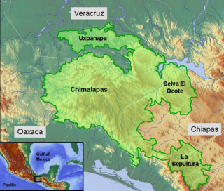
The Selva Zoque, which includes the Chimalapas rain forest, is an area of great ecological importance in Mexico. Most of the forest lies in the state of Oaxaca but parts are in Chiapas and Veracruz. It is the largest tract of tropical rainforest in Mexico, and contains the majority of terrestrial biodiversity in the country. The forest includes the Selva El Ocote, a federally-protected biosphere reserve, but is otherwise not yet protected. Despite the rich ecology of the region, a 2003 study that focused on bird populations stated that "the fauna of the heart of the Chimalapas, including its vast rainforests, have seen little or no study". As it is an impoverished region, efforts to preserve the ecology are often at odds with demands to improve the economy.

Istmo de Tehuantepec is the largest region of the state of Oaxaca, located in southwestern Mexico.
Juchitán District is located in the east of the Istmo de Tehuantepec region of the State of Oaxaca, Mexico, covering the southern part of a low-lying corridor through the mountains that separates the Gulf of Mexico from the Pacific ocean. The district has an area of 13,300 km2 and a population as of 2005 of 339,445.

The Indigenous people of Oaxaca are descendants of the inhabitants of what is now the state of Oaxaca, Mexico who were present before the Spanish invasion. Several cultures flourished in the ancient region of Oaxaca from as far back as 2000 BC, of whom the Zapotecs and Mixtecs were perhaps the most advanced, with complex social organization and sophisticated arts.
Chimalapa Zoque or Oaxaca Zoque is a Zoquean language of the municipalities of Santa María Chimalapa and San Miguel Chimalapa in Oaxaca, Mexico.
For more than 500 years, the indigenous Zoque people of Chimalapas in Southern Mexico have been victim of invasions in their territory. Chimalapas is a region with a large biodiversity and due to that it is of interest to, among others, the federal government, state governments, and a variety of companies. Therefore, throughout history several claims have been laid on this area. This goes against the will of the Zoque people, who want to take care of this land as they have done ever since they started living in this area.
The Sierra Atravesada or Sierra de Niltepec is a mountain range in the state of Oaxaca, Mexico, in the region of the Isthmus of Tehuantepec.

The Chimalapas montane forests is a tropical moist broadleaf forest ecoregion in southern Mexico. It includes the montane tropical forests of the Chimalapas region on the boundary of Chiapas and Oaxaca.

