
Caracas, officially Santiago de León de Caracas, abbreviated as CCS, is the capital and largest city of Venezuela, and the center of the Metropolitan Region of Caracas. Caracas is located along the Guaire River in the northern part of the country, within the Caracas Valley of the Venezuelan coastal mountain range. The valley is close to the Caribbean Sea, separated from the coast by a steep 2,200-metre-high (7,200 ft) mountain range, Cerro El Ávila; to the south there are more hills and mountains. The Metropolitan Region of Caracas has an estimated population of almost 5 million inhabitants.

Chacao is one of the five political and administrative subdivisions of the city of Caracas, Venezuela. The other four are Baruta, El Hatillo, Libertador and Sucre. This legal entity is known as the Caracas Metropolitan District. Chacao is also one of the 21 municipalities that make up the State of Miranda, Venezuela.

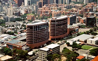
Altamira is a neighborhood located in the Chacao municipality of Caracas, Venezuela. It has its own Metro Station, many hotels and restaurants, and it is an important business and residential center of the city. It is also an important tourist destination and cultural center in Caracas. The Francisco de Miranda avenue and the Distibuidor Altamira are both located in Altamira. This neighborhood borders El Ávila National Park to the north, La Castellana neighborhood to the west, Los Palos Grandes to the east, and Bello Campo neighborhood to the south. It has an estimated area of 161 hectares or approximately 1.61 square kilometers.

Municipalities of Venezuela are subdivisions of the States of Venezuela. There are 335 municipalities dividing the 23 states and the Capital District.
Baruta is a municipality within the Metropolitan District of Caracas in Venezuela.

Escuela Campo Alegre is a K-12 American International school located in Caracas, Venezuela. It was founded in 1937 in the neighborhood of Campo Alegre, but the school grew in such a way that it had to be moved to its present location in Las Mercedes. The school provides courses from the nursery level up through 12th grade.

The Libertador Bolivarian Municipality is the only administrative division of the Capital District and along with the municipalities of Baruta, Chacao, El Hatillo and Sucre forms the Metropolitan District of Caracas. It is landlocked by Vargas State and also borders Miranda State on the east and south. The municipality is one of a number in Venezuela named "Libertador Municipality", in honour of Venezuelan independence hero Simón Bolívar.

The Francisco Fajardo Highway is the most important freeway of Caracas, connecting the west and east sides of the city. The national freeways and many of the avenues of Caracas are not designated with a system of codification or numbering; instead they are designated with the names of historical personages. This highway is named for the conquistador Francisco Fajardo. Also in Caracas, the connections between freeways are also given peculiar names - the octopus, the spider and the centipede are examples.

The municipality of San Juan is divided into 18 barrios, 16 of which fall within the former municipality of Río Piedras. Eight of the barrios are further divided into subbarrios, and they include the two barrios that originally composed the municipality of San Juan :

European Venezuelans or white Venezuelans are Venezuelan citizens who self-identify in the national census as white, tracing their heritage to European ethnic groups. According to the official census report, although "white" literally involves external issues such as light skin, shape and color of hair and eyes, among others, the term "white" has been used in different ways in different historical periods and places, and so its precise definition is somewhat confusing.

Banesco Banco Universal C.A. is a Venezuelan financial institution whose principal branch is located in Caracas. The bank is part of the Asociación Bancaria de Venezuela.
La Castellana is a district in Caracas, Venezuela, located in the northeast part of the city, La Castellana is bordered on the south by Chacao, on the east by Altamira (Caracas) neighbourhood, on the west by Caracas Country Club and Campo Alegre neighbourhood and on the north by El Ávila National Park. It has an approximate surface of 98 hectares.

Campo Alegre is a residential neighborhood located in the Chacao municipality of Caracas, Venezuela. This district holds the hotel Embassy Suites by Hilton , and the most exclusive party room of the city, the "Quinta Esmeralda", meeting point of the Venezuelan upper-class families.
Los Palos Grandes is a residential, tourist and financial district located in the Chacao Municipality in east Caracas, served by the Caracas Metro through the Miranda station of line 1. It has an estimated area of 117 hectares.

Tourism in Venezuela has been developed considerably for decades, particularly because of its geographical position, the variety of landscapes, the richness of plant and wildlife, the artistic expressions and the privileged tropical climate of the country, which affords each region throughout the year. Since 2013 the country is having a very severe economic and political crisis affecting tourism all over the country.

East Caracas generally refers to the eastern portions of Caracas, and may refer specifically to the municipalities from the Metropolitan District of Caracas located in Miranda State: Chacao, Baruta, Sucre, and El Hatillo. It concentrates the 34.8% population of the Metropolitan District of Caracas, and the 21.7% population of the Greater Caracas Area. Caracas Country Club, the richest neighborhood of the city, is located between El Recreo and Chacao districts.
The Sabana Grande district is divided into several middle class neighborhoods located in the Parroquia El Recreo of the Libertador Municipality, in the geographical center of the Metropolitan District of Caracas and owes its name to the old town of Sabana Grande.
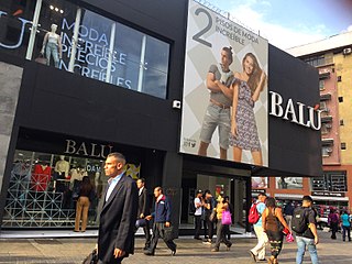
The Boulevard of Sabana Grande is an important leisure and shopping area located in eastern Caracas in the geographic center of the Metropolitan District of Caracas. It is a pedestrian-only, tree-shaded public space. In 2011, the boulevard of Sabana Grande went through a rehabilitation process founded by PDVSA La Estancia. A commercial and financial district, Sabana Grande is the commercial corridor, and a tourist district of Caracas. The boulevard of Sabana Grande is home to the most important ornithological collection in Latin America, the William Phelps Ornithological Collection. Until the beginning of the 20th century, it was called Calle Real because it was the town's main road.

El Cafetal is a neighborhood located in the Baruta Municipality of Caracas, Venezuela.
